文章目录
- 前言
- Geo介绍
- Geo指令使用
- 使用场景:附近的人
- 参考文献
前言
- Redis除了常见的五种数据类型之外,其实还有一些少见的数据结构,如Geo,HyperLogLog等。虽然它们少见,但是作用却不容小觑。本文将介绍Geo指令的语法和使用场景。
Geo介绍
- Geo是"geolocation"的缩写,即地理定位器,顾名思义就是记录地理位置信息,用来进行地址位置排序的数据结构。所以它场景的应用场景便是寻找附近的人,最佳路线推荐等等。
- 说到地址位置排序,不得不提地理位置距离排序算法GeoHash算法,Redis也使用了这个算法。简单来说,这个算法就是将某地点的经度和纬度进行编码之后,成为的一维整数,整数越接近,两个地点也就越接近。通过整数可以还原出经纬度坐标,整数越长,还原出来的坐标损失程度就越小。GeoHash算法会继续对这个整数做一次base32编码,使其变成字符串。
- 于是在使用Geo数据结构时,可以简单地理解为,它只是一个zset,score是元素地址经过GeoHash算法得到的52位整数(在Redis里面,经纬度使用52位的整数进行编码),value存放该元素。
Geo指令使用
-
向Geo中添加地理空间信息:geoadd key 经度 纬度 具体元素
geoadd restaurant 95 20 "沙县小吃" geoadd restaurant 96 19 "肯德基" 120 27 "麦当劳" -
返回指定两个元素的距离:geodist key 元素1 元素2 距离单位
geodist restaurant "沙县小吃" "肯德基" km -
获取元素坐标:geopos key 元素1 … 元素n
geopos restaurant "麦当劳" geopos restaurant "沙县小吃" "肯德基" -
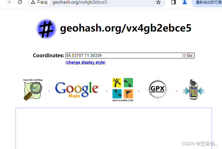
获取指定元素坐标的hash字符串:geohash key 元素1
geohash restaurant "沙县小吃"获取到的hash值可以到 http://geohash.org/${hash} 上进行定位,得到经纬度坐标
-
指定圆心半径,找到该圆范围内的所有元素,并按与圆心距离排序后返回:georadius key 经度 纬度 半径 单位 withdist/withcoord/withhash count n des/asc
georadius restaurant 95 21 100 km withdist count 3 asc # 查找经度95 纬度21的地点半径100公里以内的餐馆,正序输出三个餐馆withdist: 同时返回该元素与圆心的距离,距离单位为georadius指令指定的单位
withhash: 同时返回52位整数编码后的字符串
withcoord: 同时返回该元素的经纬度坐标
使用场景:附近的人
-
需求:实现查看附近的人功能。
-
实现方案:使用geo数据结构,将用户的位置经纬度保存在geo中,然后对这些信息进行查询。
-
代码实现:代码中saveUserLocation()方法负责添加用户位置信息,在添加时使用outOfChina()方法判断做位置检验,是否用户位置在国内,不在国内就不保存了,deleteUserLocation()方法负责删除某用户的位置信息,getNearByLocation()方法负责查询某个地方附近的用户。
public class NearbyPeopleDemo { public static void main(String[] args) { Jedis jedis = new Jedis("127.0.0.1"); jedis.del(LOCATION_KEY); double lon ; double lat ; //向redis中存放用户的地址,随机生成一万个用户。 for(int i = 0;i<10000;i++){ lon = Math.random()*(138-72+1)+72; lat = Math.random()*(55-0+1); //判断该位置是否属于中国,不属于就不加了 if(!outOfChina(lon,lat)) { saveUserLocation("用户"+i, lon, lat, jedis); } } System.out.println("添加用户位置信息完毕!"); System.out.println("距离经度100,纬度35位置100km以内的人有哪些:"+ getNearByLocation(100, 35, 100, jedis)); } private static final String LOCATION_KEY = "location"; /** * 保存用户位置信息 * @param userId 用户id * @param longitude 经度 * @param latitude 纬度 * @param jedis */ public static void saveUserLocation(String userId, double longitude, double latitude, Jedis jedis){ jedis.geoadd(LOCATION_KEY,longitude,latitude,userId); } /** * 根据用户id删除用户位置信息,采用zset的删除方式删除即可 * @param userId * @param jedis */ public static void deleteUserLocation(String userId,Jedis jedis){ jedis.zrem(LOCATION_KEY,userId); } /** * 查询附近的人 * @param longitude 经度 * @param latitude 纬度 * @param radius 半径 * @param jedis * @return */ public static List<String> getNearByLocation(double longitude, double latitude,double radius,Jedis jedis){ List<GeoRadiusResponse> georadius = jedis.georadius(LOCATION_KEY, longitude, latitude, radius, GeoUnit.KM); return georadius.stream().map(GeoRadiusResponse::getMemberByString).collect(Collectors.toList()); } /** * 判断经纬度是否超过了中国 * @param longitude 经度 * @param latitude 纬度 * @return */ public static boolean outOfChina(double longitude,double latitude) { if (longitude < 72.004 || longitude > 137.8347) return true; if (latitude < 0.8293 || latitude > 55.8271) return true; return false; } } -
测试结果:我们在main方法中,随机生成一万个用户位置信息,保存在redis中,之后调用getNearByLocation()方法查找距离经度100,纬度35的位置100km以内的人有哪些,运行结果如下:

参考文献
- 《91.Redis深度历险 核心原理与应用实践》–钱文品


![[HTML]Web前端开发技术14(HTML5、CSS3、JavaScript )鼠标经过图片显示大图 网页标题:表格标签的综合应用——喵喵画网页](https://img-blog.csdnimg.cn/direct/b90f8a1784d84d3cb4eeb93bd2ec8442.png)
