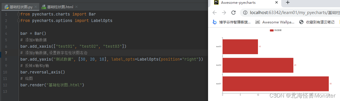
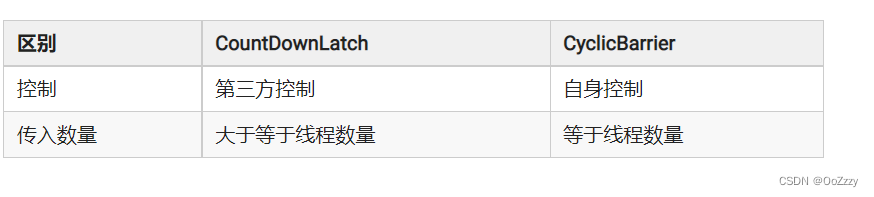
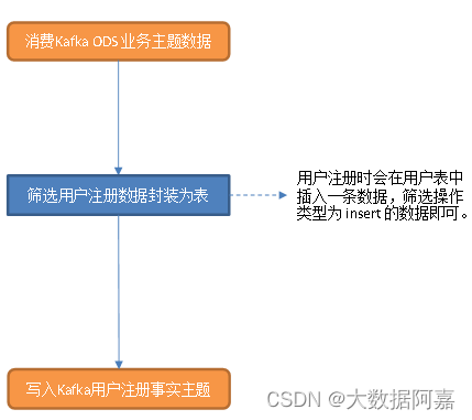
QML地图Map中提供了供绘制图形的组件,例如MapPolyline,MapCircle等,但是这些组件在绘制复杂轨迹时就显得功能不够全面,因此我将QPainterPath在Map中进行使用并进行绘制,并使用C++和Qml中的函数进行相互调用计算获取点屏幕坐标和经纬度坐标。例子中使用了QPainterPath的QPainterPath::pointAtPercent获取绘制的轨迹全过程中的各个位置的经纬度。效果如图:
QML主要功能为地图显示,其中Plugin中定义的路径为我地图瓦片存放路径,你们需要修改为自己的或者直接使用在线地图。我们自定义了一个类 MapPainter,该类继承至QQuickPaintedItem,并通过元对象系统注册至QML中,覆盖到Map上方作为画布使用。
Demo项目地址:https://github.com/zjgo007/QmlDemo/tree/master/MapPainter![]() https://github.com/zjgo007/QmlDemo/tree/master/MapPainter
https://github.com/zjgo007/QmlDemo/tree/master/MapPainter
main.qml
import QtQuick 2.9
import QtQuick.Window 2.2
import QtLocation 5.9
import QtPositioning 5.9
import QtQuick.Controls 2.9

import MapPainter 1.0

Window {
    id:window
    width: 640
    height: 480
    visible: true
    title: qsTr("Map Painter Path")

    Plugin {
        id: mapPlugin
        name: "osm" // "mapboxgl", "esri", ...

        PluginParameter{//自定义地图瓦片路径
            name:"osm.mapping.offline.directory"
            value: "G:/Map/"
        }

        PluginParameter{
            name:"osm.mapping.offline.maptiledir"
            value:true
        }

    }

    Map {
        id: myMap
        center: QtPositioning.coordinate(24,104)
        anchors.fill: parent
        plugin: mapPlugin

        zoomLevel: 8
        color: "#00000000"
        copyrightsVisible: false
        activeMapType: supportedMapTypes[2]

//        onVisibleRegionChanged: {//Qt 5.15以上使用
//            mapPainter.mapRegionChanged()
//        }

        onCenterChanged: {//Qt 5.15以下使用
            mapPainter.mapRegionChanged()
        }

        onZoomLevelChanged: {//Qt 5.15以下使用
            mapPainter.mapRegionChanged()
        }

        MapPainter{
            id:mapPainter
            anchors.fill: parent
        }

        MapQuickItem{
            id: anchorMarker
            width: 50
            height: 36
            anchorPoint.x: image.width/2
            anchorPoint.y: image.height
            coordinate: myMap.center

            sourceItem: Item{
                Image {
                    id:image
                    source: "qrc:/anchor.png"
                    sourceSize.height: 36
                    sourceSize.width: 50
                }
                Text {
                    id: label
                    y:-15
                    color: "#00ffff"
                    text: qsTr("")
                    font.bold: true
                    font.pointSize: 11
                    font.family: "微软雅黑"
                }
            }
        }
        MouseArea {
            id: mouseArea_measure
            anchors.fill: parent
            onClicked: {
                var coordinate = myMap.toCoordinate(Qt.point(mouse.x, mouse.y))
                mapPainter.addPathPoint(mouse.x, mouse.y,coordinate)
                anchorMarker.coordinate = coordinate
            }
        }
    }

    Slider {
        id: slider
        x: 430
        y: 10
        stepSize: 0.01
        value: 1
        onValueChanged: {
            var coordinate = mapPainter.mapPathData(value)
            anchorMarker.coordinate = coordinate
            label.text = "("+coordinate.latitude.toFixed(4)+","+coordinate.longitude.toFixed(4)+")"
        }
    }
    Component.onCompleted: {
        mapPainter.setQmlObject(window)
    }

    function transGeoToPoint(coordinate){
        return myMap.fromCoordinate(coordinate,false)
    }

    function transPointToGeo(pointf){
        return myMap.toCoordinate(pointf,false)
    }
}
其中需要注意的是,在QML的Component.onCompleted信号发出后,需要该QML的QObject传递至MapPainter中,便于在C++中调用qml里定义的函数,这两个函数用于经纬度坐标和屏幕坐标转换。
Component.onCompleted: {
        mapPainter.setQmlObject(window)
    }

    function transGeoToPoint(coordinate){
        return myMap.fromCoordinate(coordinate,false)
    }

    function transPointToGeo(pointf){
        return myMap.toCoordinate(pointf,false)
    }
在C++中,addPathPoint(qreal x,qreal y,QGeoCoordinate coordinate)函数用于传入鼠标点击位置的屏幕坐标和经纬度坐标。mapRegionChanged()用于标记当前地图已被平移或者缩放,需要重新绘制轨迹。
同时自定义了类GeoPainterPath,该类记录了鼠标绘制轨迹的点位置和绘制方式,我只简单的放了MoveTo和LineTo,其他绘制方式可自行添加。
mappainter.h
#ifndef MAPPAINTER_H
#define MAPPAINTER_H

#include <QQuickPaintedItem>
#include <QObject>
#include <QPainter>
#include <QPainterPath>
#include <QGeoCoordinate>

class GeoPainterPath
{
public:
    GeoPainterPath() {}
    ~GeoPainterPath(){}

    enum PainterType{
        None,
        MoveTo,
        LineTo
    };

    void addGeoPath(PainterType type,QGeoCoordinate coordinate);

    PainterType painterType(int index);

    QGeoCoordinate coordinate(int index);

    int size();

    void clear();

private:
    QList<PainterType> typeList;
    QList<QGeoCoordinate> geoList;
};

class MapPainter : public QQuickPaintedItem
{
    Q_OBJECT
public:
    MapPainter(QQuickItem *parent = nullptr);
    ~MapPainter();
    virtual void paint(QPainter *painter) Q_DECL_OVERRIDE;

    Q_INVOKABLE void setQmlObject(QObject* object);

public slots:
    void addPathPoint(qreal x,qreal y,QGeoCoordinate coordinate);
    void updatePainterPath();
    void mapRegionChanged();

    QGeoCoordinate mapPathData(qreal percent);

private:
    QPainterPath* testPath;
    bool pathDirty;
    GeoPainterPath mGeoPainterPath;
    QObject* qmlObject;
};


#endif // MAPPAINTER_H
mappainter.cpp
#include "mappainter.h"

MapPainter::MapPainter(QQuickItem *parent):QQuickPaintedItem(parent),pathDirty(false)
{
    testPath = new QPainterPath();
    connect(this,&QQuickPaintedItem::widthChanged,this,&MapPainter::mapRegionChanged);
    connect(this,&QQuickPaintedItem::heightChanged,this,&MapPainter::mapRegionChanged);
}

MapPainter::~MapPainter()
{
    delete testPath;
}

void MapPainter::paint(QPainter *painter)
{
    if(pathDirty)
        updatePainterPath();

    painter->setPen(QPen(QColor("red"), 2, Qt::SolidLine,
                         Qt::RoundCap, Qt::RoundJoin));

    painter->drawPath(*testPath);
}

void MapPainter::setQmlObject(QObject *object)
{
    qmlObject = object;
}

void MapPainter::addPathPoint(qreal x, qreal y, QGeoCoordinate coordinate)
{
    if(testPath->elementCount()==0){
        testPath->moveTo(x,y);
        mGeoPainterPath.addGeoPath(GeoPainterPath::MoveTo,coordinate);
    }else{
        testPath->lineTo(x,y);
        mGeoPainterPath.addGeoPath(GeoPainterPath::LineTo,coordinate);
    }
    update();
}

void MapPainter::updatePainterPath()
{
    if(qmlObject){
        testPath->clear();
        int size = mGeoPainterPath.size();
        for(int i=0;i<size;i++){
            QGeoCoordinate coordinate = mGeoPainterPath.coordinate(i);
            QVariant mapPointVar;
            QMetaObject::invokeMethod(qmlObject,"transGeoToPoint",Qt::DirectConnection,
                                      Q_RETURN_ARG(QVariant,mapPointVar),
                                      Q_ARG(QVariant,QVariant::fromValue(coordinate))
                                      );
            GeoPainterPath::PainterType painterType = mGeoPainterPath.painterType(i);
            QPointF mapPoint = mapPointVar.toPointF();
            switch (painterType) {
            case GeoPainterPath::MoveTo:
                testPath->moveTo(mapPoint);
                break;
            case GeoPainterPath::LineTo:
                testPath->lineTo(mapPoint);
                break;
            default:
                break;
            }
        }
        pathDirty = false;
    }
}

void MapPainter::mapRegionChanged()
{
    pathDirty = true;
    update();
}

QGeoCoordinate MapPainter::mapPathData(qreal percent)
{
    QPointF pointf = testPath->pointAtPercent(percent);
    QVariant coordinateVar;
    QMetaObject::invokeMethod(qmlObject,"transPointToGeo",Qt::DirectConnection,
                              Q_RETURN_ARG(QVariant,coordinateVar),
                              Q_ARG(QVariant,QVariant::fromValue(pointf)));
    return coordinateVar.value<QGeoCoordinate>();
}

void GeoPainterPath::addGeoPath(PainterType type, QGeoCoordinate coordinate)
{
    typeList.append(type);
    geoList.append(coordinate);
}

GeoPainterPath::PainterType GeoPainterPath::painterType(int index)
{
    if(index>=typeList.size()){
        return PainterType::None;
    }
    return typeList.at(index);
}

QGeoCoordinate GeoPainterPath::coordinate(int index)
{
    if(index>=geoList.size()){
        return QGeoCoordinate();
    }
    return geoList.at(index);
}

int GeoPainterPath::size()
{
    return geoList.size();
}

void GeoPainterPath::clear()
{
    typeList.clear();
    geoList.clear();
}
Demo项目地址:https://github.com/zjgo007/QmlDemo/tree/master/MapPainter![]() https://github.com/zjgo007/QmlDemo/tree/master/MapPainter
https://github.com/zjgo007/QmlDemo/tree/master/MapPainter


![[附源码]Python计算机毕业设计 社区老人健康服务跟踪系统](https://img-blog.csdnimg.cn/f19c1b23ca474c379f53e7c74376e327.png)