截至到目前阶段的功能,我自己实现最完整的代码
import "ol/ol.css";
import Map from "ol/Map";
import Feature from "ol/Feature";
import VectorSource from "ol/source/Vector";
import Overlay from "ol/Overlay";
import { Tile as TileLayer, Vector as VectorLayer } from "ol/layer";
import View from "ol/View";
import { transform, fromLonLat } from "ol/proj";
import XYZ from "ol/source/XYZ";
import { Point, LineString } from "ol/geom";
import GeoJSON from "ol/format/GeoJSON";
import { Fill, Stroke, Icon, Style } from "ol/style";
import markerImg from "@/assets/images/fly.svg";
import markerCenter from "@/assets/images/centerPos.png";
import markerCurrent from "@/assets/images/curPos.png";
data() {
return {
mapObj: null,
mapDom: null,
mapPointList: [],
pointLayerSource: null,
pointLayer: null, // 绘制地图中心点的图层
markerIcon: markerImg,
markerCenterIcon: markerCenter,
markerCurrentIcon: markerCurrent,
extent: [121.5509, 31.0865, 121.8109, 31.382],
tileUrl: "http://192.168.1.103:8081" + "/{z}/{x}/{y}.jpg",
routeLayer: {},
featureMove: {},
coordinates: [
[121.70185, 31.298777],
[121.70285, 31.296777],
[121.70385, 31.295777],
[121.70585, 31.294777],
],
routeIndex: 0, //当前小车所在的路段
carLayer: null,
timer: null, // 计时器
speed: null,
coverPoints: [
[121.70585, 31.294777],
[121.70585, 31.294777],
],
currentCoodinate: null,
mapTypeFlag: false,
centerPoint: { longitude: 121.70185, latitude: 31.298777 },
};
},
mounted() {
this.initMap();
// this.openLine();
// 设置 默认的中心点坐标
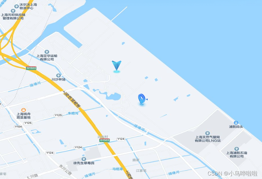
this.addPoint(
this.centerPoint,
this.markerCenterIcon,
"centerIconLayer",
"centerIconFeatureId"
);
this.mapObj.on("click", (evt) => {
// 获取当前点击点的 feature,如果存在就移除
const feature = this.pointLayerSource.getFeatureById("curIconFeatureId");
if (feature) {
this.pointLayerSource.removeFeature(feature);
}
this.addFeature(evt, this.markerCurrentIcon, "curIconFeatureId");
});
},
methods: {
initMap() {
// 获取地图容器
this.mapDom = document.getElementById("map");
// 初始化地图配置
this.mapObj = new Map({
target: this.mapDom, // 地图容器
view: new View({
center: [121.70185, 31.298777], // 地图中心点
zoom: 15,
minZoom: 14,
maxZoom: 18,
// EPSG: 3857 --web地图,基于球体的、web墨卡托投影(伪墨卡托投影Pseudo-Mercator)的投影坐标系,范围为纬度85度以下,由于google地图最先使用而成为事实标准。至今,大多互联网地图都使用EPSG3857,主要是因为该投影是等角投影,适合地图定向及导航,但是纬度越高,面积变形越大。
// EPSG: 4326 --全球通用,基于WGS84椭球的经纬度坐标系,大地坐标系
projection: "EPSG:4326", // 投影
extent: this.extent,
}),
});
// 添加一个使用离线瓦片地图的层
const offlineMapLayer = new TileLayer({
source: new XYZ({
url: this.tileUrl,
}),
});
// 将图层添加到地图
this.mapObj.addLayer(offlineMapLayer);
},
// 加载地理坐标 -- 设置中心点
handleSetMapCenter() {
// 获取当前点击点、默认中心点的feature
const curFeature =
this.pointLayerSource.getFeatureById("curIconFeatureId");
const centerFeature = this.pointLayerSource.getFeatureById(
"centerIconFeatureId"
);
if (!curFeature || !centerFeature) {
return;
}
// 首先移除curFeature
this.pointLayerSource.removeFeature(curFeature);
// 这里直接修改 原来中心点的坐标及样式
centerFeature.getGeometry().setCoordinates(this.currentCoodinate);
const newStyle = new Style({
image: new Icon({
color: "#ffffff",
crossOrigin: "anonymous",
src: this.markerCenterIcon,
}),
});
centerFeature.setStyle(newStyle);
// 修改原来中心点的坐标值
this.centerPoint = {
longitude: this.currentCoodinate[0],
latitude: this.currentCoodinate[1]
}
},
// 回到中心点
handleBackMapCenter() {
let view = this.mapObj.getView();
view.setZoom(15);
view.setCenter([this.centerPoint.longitude, this.centerPoint.latitude], "EPSG:4326", "EPSG:3857");
this.mapObj.render();
},
// 地图点击事件
addFeature(evt, src, id) {
this.currentCoodinate = evt.coordinate;
if (!Array.isArray(this.currentCoodinate)) {
return;
}
const location = {
longitude: this.currentCoodinate[0],
latitude: this.currentCoodinate[1],
};
// 创建点击后的元素
const point = new Feature({
geometry: new Point([location.longitude, location.latitude]),
data: location,
});
// 点的样式
const iconStyle = new Style({
image: new Icon({
color: "#ffffff",
crossOrigin: "anonymous",
src: src,
}),
});
// 设置样式
point.setStyle(iconStyle);
point.setId(id);
this.addFeatureToLayer(point, "centerIconLayer");
},
// 在图层上新增元素
addFeatureToLayer(feature, layerId) {
const layer = this.getLayerById(layerId);
const layerSource = layer.getSource();
layerSource.addFeature(feature);
},
// 根据图层id来获取图层
getLayerById(layerId) {
const layers = this.mapObj.getLayers().getArray();
for (let i = 0; i < layers.length; i++) {
if (layers[i].get("id") === layerId) {
return layers[i];
}
}
return null;
},
// 添加地理坐标点
addPoint(location, src, layerId, featureId) {
// 地理坐标数组
const pointData = [location];
pointData.map((item) => {
// 创建点
const point = new Feature({
geometry: new Point([item.longitude, item.latitude]),
data: item,
});
// 点的样式
const iconStyle = new Style({
image: new Icon({
color: "#ffffff",
crossOrigin: "anonymous",
src: src,
}),
});
// 设置样式
point.setStyle(iconStyle);
point.setId(featureId);
this.mapPointList.push(point);
});
// 创建geojson据源
this.pointLayerSource = new VectorSource({ features: this.mapPointList });
// 创建图层 并加载数据
this.pointLayer = new VectorLayer({
source: this.pointLayerSource,
// 图层的id,这也非常重要
id: layerId,
});
// 将图层添加地图上
this.mapObj.addLayer(this.pointLayer);
},
}