前言
osgearth_cluster示例,展示了绘制很多模型时,如何合适设置模型遮挡的混乱情况。
当模型过多时,可以创建 osgEarth::Util::ClusterNode 节点对象,然后创建 osg::NodeList,将需要绘制的节点 node 们,都 push_back 到 osg::NodeList 中,然后将 osg::NodeList 添加 addChild 到 osgEarth::Util::ClusterNode 中,通过控制 osgEarth::Util::ClusterNode 的半径范围,来控制节点node们的显示密集程度。
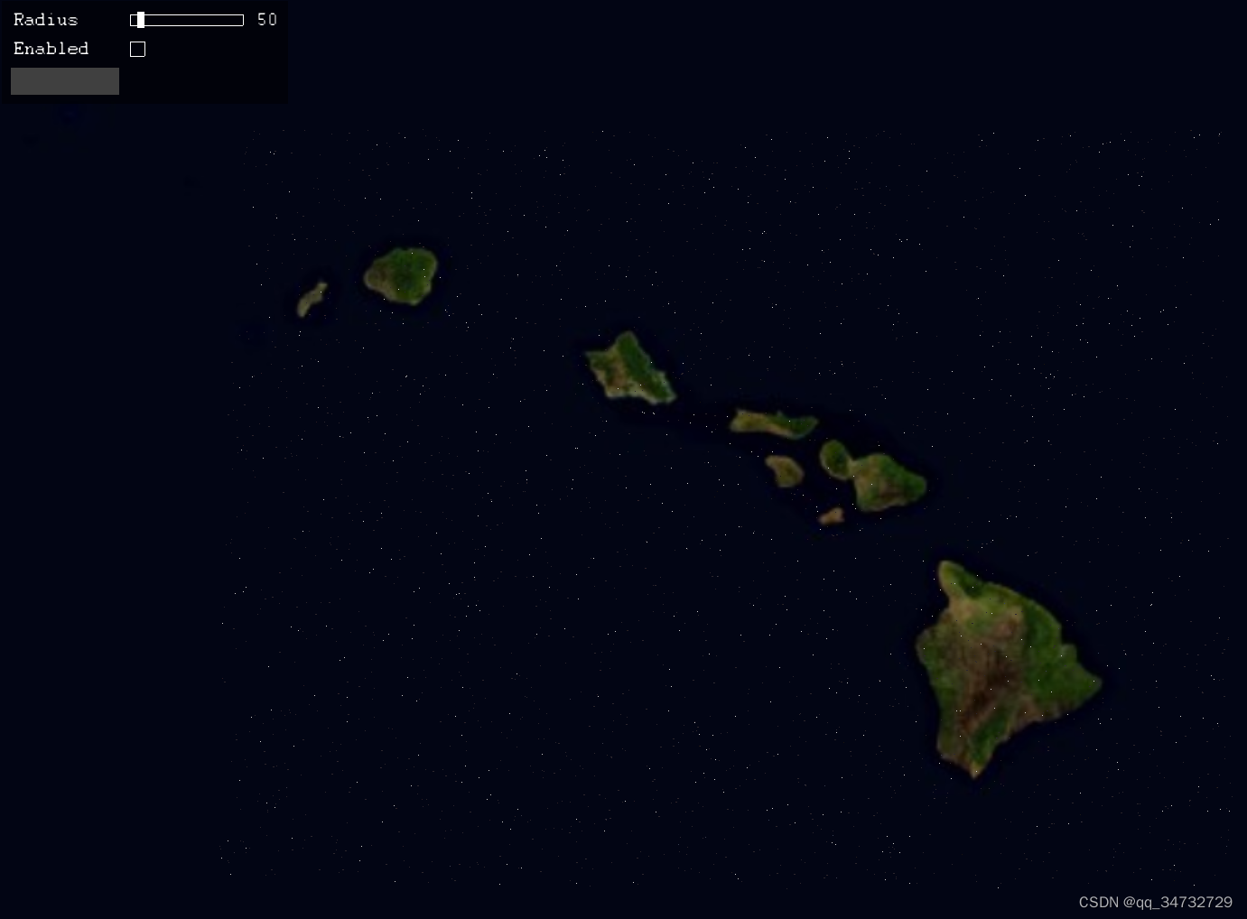
执行效果
执行命令如下:
// 简单的earth文件即可
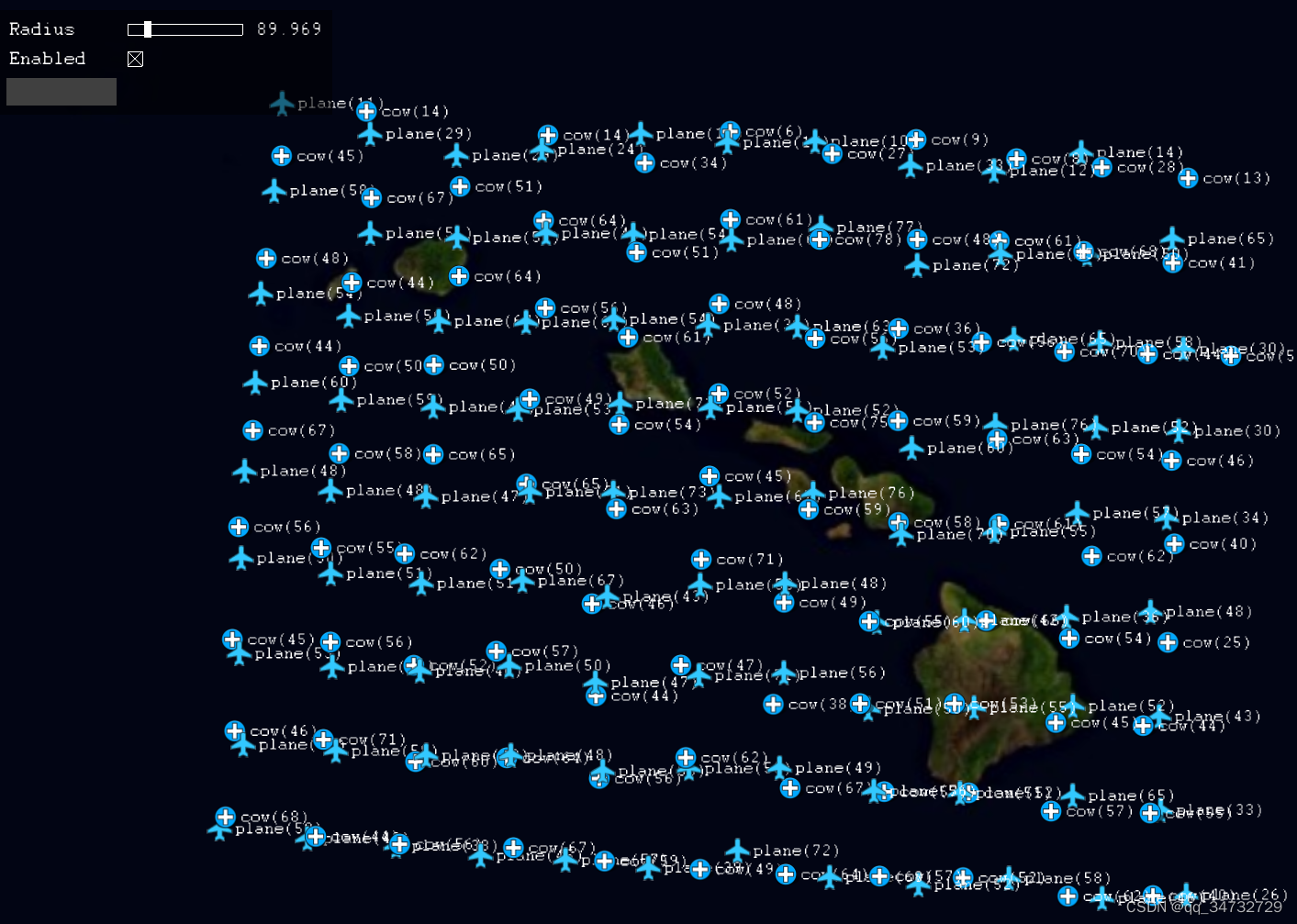
osgearth_clusterd.exe earth_image\world.earth绘制10000个飞机和牛的模型,并且为其添加icon图标。当距离较远时,会显示图标。拉进后,才现实模型。
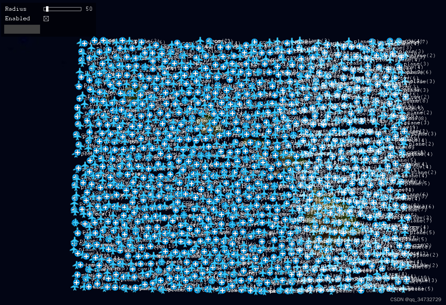
Enabled的复选框被取消勾选后,图上的模型、图标、文本,都会消失,取而代之的是culler,像玻璃碎渣。
当扩大半径值时,所有的模型看起来稀疏了不少。但数量并没有改变。只是距离相近的相同的模型用1个图标显示,并且文本中会显示当前标签下,有多少个模型。类似地图中显示的那样。视觉上更友好些。
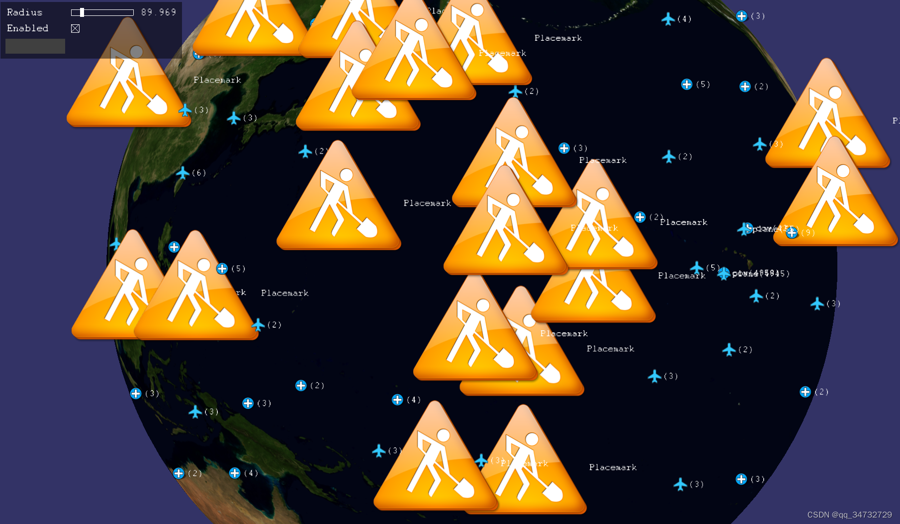
Enabled的下方灰色矩形是按钮(自带按钮确实丑了点)。点击按钮,会随机生成很多PlaceNode。这些黄色的图标,也会随着视距增加,合并成一个小的图标,比如飞机或者医院的图标,然后显示当前隐藏的黄色图标的个数。
代码分析
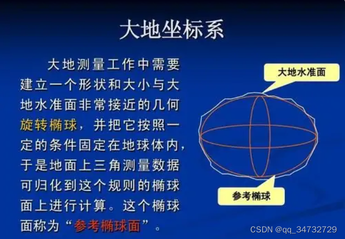
额外先分析一下坐标系,毕竟经常会用到。
// 通过mapNode获取到空间坐标系类
osgEarth::SpatialReference* geoSRS = mapNode->getMapSRS();

// 在 osgEarth::SpatialReference 类中,有几种获取坐标系的方式:

// 地理坐标系,一般高度。
getGeographicSRS();

// 大地测量坐标系,获取内容同上,但是z值为:大地椭球之上的z值.
// 当存在地形数据时,此方法用的较多。
getGeodeticSRS();

// 获取与此SRS椭球体关联的地心参考系。代码中,用的较少
getGeocentricSRS();
一、性质不同
1、地理坐标系(GeographicCoordinateSystem),是使用三维球面来定义地球表面位置,以实现通过经纬度对地球表面点位引用的坐标系。
2、大地坐标系是大地测量中以参考椭球面为基准面建立起来的坐标系。
二、作用不同
1、地理坐标系:定义了地表点位的经纬度,并且根据其所采用的参考椭球体参数还可求得点位的绝对高程值。
2、大地坐标系:是大地测量的基本坐标系,它是大地测量计算,地球形状大小研究和地图编制等的基础。
参考链接:地理坐标系和大地坐标系的区别_百度知道
代码分析:
#include <osgViewer/Viewer>
#include <osgEarth/Notify>
#include <osgEarthUtil/EarthManipulator>
#include <osgEarthUtil/ExampleResources>
#include <osgEarth/MapNode>
#include <osgEarth/ThreadingUtils>
#include <osgEarth/Metrics>
#include <osgEarth/Registry>
#include <iostream>

#include <osgEarthAnnotation/PlaceNode>

#include <osgEarthUtil/ClusterNode>

#define LC "[viewer] "

using namespace osgEarth;
using namespace osgEarth::Util;
using namespace osgEarth::Annotation;

int
usage(const char* name)
{
    OE_NOTICE
        << "\nUsage: " << name << " file.earth" << std::endl
        << MapNodeHelper().usage() << std::endl;

    return 0;
}

// 在extent的包围盒内,创建placeNode,1000=count,存储在nodes中
void makePlaces(MapNode* mapNode, unsigned int count, const GeoExtent& extent, osg::NodeList& nodes)
{
    // set up a style to use for placemarks:
    Style placeStyle;
	// 关闭清除
    placeStyle.getOrCreate<TextSymbol>()->declutter() = false;

    // A lat/long SRS for specifying points.获取地理坐标系
    const SpatialReference* geoSRS = mapNode->getMapSRS()->getGeographicSRS();

    //--------------------------------------------------------------------

    {
        osg::ref_ptr<osg::Image> pin = osgDB::readRefImageFile("icon.png");

        for (unsigned int i = 0; i < count; i++)
        {
			// 随机生成经纬度
            double lat = extent.yMin() + extent.height() * (rand() * 1.0) / (RAND_MAX - 1);
            double lon = extent.xMin() + extent.width() * (rand() * 1.0) / (RAND_MAX - 1);
            PlaceNode* place = new PlaceNode("Placemark", placeStyle, pin.get());
            place->setPosition(GeoPoint(geoSRS, lon, lat, 0.0));// 贴地
            place->setMapNode(mapNode);
            place->setDynamic(true);// 动态开启
            nodes.push_back(place);
        }
    }
}

// 创建模型,传入的map节点、数量、在包围盒范围、模型node列表
void makeModels(MapNode* mapNode, unsigned int count, const GeoExtent& extent, osg::NodeList& nodes)
{
	// 读取模型,长宽高方向扩大的倍数???
    osg::ref_ptr< osg::Node > cessna = osgDB::readRefNodeFile("cessna.osg.10,10,10.scale");
    osg::ref_ptr< osg::Node > cow = osgDB::readRefNodeFile("cow.osg.100,100,100.scale");
    osgEarth::Registry::shaderGenerator().run(cessna.get());// 采用 默认着色器生成器
    osgEarth::Registry::shaderGenerator().run(cow.get());

    // A lat/long SRS for specifying points.地理坐标系
    const SpatialReference* geoSRS = mapNode->getMapSRS()->getGeographicSRS();

    bool useCow = false;

    for (unsigned int i = 0; i < count; i++)
    {
		// 随机生成经纬度
        double lat = extent.yMin() + extent.height() * (rand() * 1.0) / (RAND_MAX - 1);
        double lon = extent.xMin() + extent.width() * (rand() * 1.0) / (RAND_MAX - 1);

		// 接受地理空间坐标的变换节点 transform
        GeoTransform* transform = new GeoTransform();
		// 高度值默认1000
        transform->setPosition(GeoPoint(geoSRS, lon, lat, 1000));
        if (useCow)
        {
            transform->addChild(cow.get());
            transform->setName("cow");
        }
        else
        {
            transform->addChild(cessna.get());
            transform->setName("plane");
        }
        nodes.push_back(transform);
        useCow = !useCow;// 两个模型交替绘制
    }
}

// 将view传入,创建控制面板容器
Container*
createControlPanel(osgViewer::View* view)
{
    ControlCanvas* canvas = ControlCanvas::getOrCreate(view);
    VBox* vbox = canvas->addControl(new VBox());// 垂直box
    vbox->setChildSpacing(10);
    return vbox;
}

// 设置半径控制事件,主要是改变clusterNode的包围盒半径
struct SetRadius : public ControlEventHandler
{
    SetRadius(ClusterNode* clusterNode) :
        _clusterNode( clusterNode )
    { }

    void onValueChanged(Control* control, float value)
    {
        _clusterNode->setRadius(value);
    }

    ClusterNode* _clusterNode;
};

// 添加图标
struct AddIcons : public ControlEventHandler
{
    AddIcons(ClusterNode* clusterNode, MapNode* mapNode) :
        _clusterNode(clusterNode),
        _mapNode(mapNode)
    { }
	// 点击button时
    void onClick(Control* button)
    {
        osg::NodeList nodes;
        GeoExtent extent(SpatialReference::create("wgs84"), -180, -90, 180, 90);
        makePlaces(_mapNode, 1000, extent, nodes);// 在extent的包围盒内,创建placeNode
		std::cout << "PlaceNode nodes.size() " << nodes.size() << std::endl;
        for (unsigned int i = 0; i < nodes.size(); ++i)
        {
            _clusterNode->addNode(nodes[i].get());
        }
    }

    ClusterNode* _clusterNode;
    MapNode* _mapNode;
};

// 是否clusterNode使能
struct ToggleEnabled : public ControlEventHandler
{
    ToggleEnabled(ClusterNode* clusterNode) :
        _clusterNode(clusterNode)
    { }

    virtual void onValueChanged(Control* control, bool value) {
        _clusterNode->setEnabled(value);// 像碎玻璃,关闭后,所有文本、模型都变为点
    }

    ClusterNode* _clusterNode;
};

// 创建控件
void buildControls(Container* container, ClusterNode* clusterNode, MapNode* mapNode)
{
    // the outer container:
	// new 网格容器
    Grid* grid = container->addControl(new Grid());
    grid->setBackColor(0, 0, 0, 0.5);// 半透明黑色背景
    grid->setMargin(10);// 外边距
    grid->setPadding(10);// 内边距
    grid->setChildSpacing(10);// 子控件间的距离
    grid->setChildVertAlign(Control::ALIGN_CENTER);// 子控件垂直居中
    grid->setAbsorbEvents(true);// 接收事件
    grid->setVertAlign(Control::ALIGN_TOP);// 网格控件

    // Radius 控制半径的标签
    LabelControl* radiusLabel = new LabelControl("Radius");
    radiusLabel->setVertAlign(Control::ALIGN_CENTER);
    grid->setControl(0, 0, radiusLabel);

	// 水平滑动条控件,进而改变clusterNode的包围盒半径
    HSliderControl* radiusAdjust = new HSliderControl(1, 500, clusterNode->getRadius(), new SetRadius(clusterNode));
    radiusAdjust->setWidth(125);
    radiusAdjust->setHeight(12);
    radiusAdjust->setVertAlign(Control::ALIGN_CENTER);
    grid->setControl(1, 0, radiusAdjust);
	// 将radiusAdiust的value值,写在lable控件上,用于显示半径
    grid->setControl(2, 0, new LabelControl(radiusAdjust));

	// 第1行第2列label控件
    grid->setControl(0, 1, new LabelControl("Enabled"));
    CheckBoxControl* checkBox = new CheckBoxControl(clusterNode->getEnabled());
    checkBox->setHorizAlign(Control::ALIGN_LEFT);
    checkBox->addEventHandler(new ToggleEnabled(clusterNode));// 切换是否clusterNode使能事件
    grid->setControl(1, 1, checkBox);// 第二行第二列

    // 1行3列,按钮,加图标事件,灰色的按钮,鼠标移动上去,会变为蓝色按钮
    grid->setControl(0, 2, new ButtonControl("Add Icons", new AddIcons(clusterNode, mapNode)));

}

//! Displays a simplified count for the cluster instead of the exact number.
// 简单计算个数的回调方法
class SimplifyCountCallback : public ClusterNode::StyleClusterCallback
{
public:
    virtual void operator()(ClusterNode::Cluster& cluster)
    {
        if (cluster.nodes.size() >= 100)
        {
            cluster.marker->setText("100+");
        }
        else if (cluster.nodes.size() >= 50)
        {
            cluster.marker->setText("50+");
        }
        else if (cluster.nodes.size() >= 25)
        {
            cluster.marker->setText("25+");
        }
        else if (cluster.nodes.size() >= 10)
        {
            cluster.marker->setText("10+");
        }
        else
        {
            cluster.marker->setText("2+");
        }
    }
};

//! Changes the name of a marker based on the name of the clustered nodes.
class StyleByNameCallback : public ClusterNode::StyleClusterCallback
{
public:

    StyleByNameCallback()
    {
        _planeImage = osgDB::readRefImageFile("airport.png");
        _cowImage = osgDB::readRefImageFile("hospital.png");
    }

    virtual void operator()(ClusterNode::Cluster& cluster)
    {
        std::stringstream buf;
        buf << cluster.nodes[0]->getName() << "(" << cluster.nodes.size() << ")" << std::endl;
        cluster.marker->setText(buf.str());

        if (cluster.nodes[0]->getName() == "plane")
        {
            cluster.marker->setIconImage(_planeImage.get());
        }
        else if (cluster.nodes[0]->getName() == "cow")
        {
            cluster.marker->setIconImage(_cowImage.get());
        }
    }

    osg::ref_ptr< osg::Image > _planeImage;
    osg::ref_ptr< osg::Image > _cowImage;
};

//! Only allows nodes with the same name to be clustered together.
class ClusterByNameCallback : public ClusterNode::CanClusterCallback
{
public:
    virtual bool operator()(osg::Node* a, osg::Node* b)
    {
        return (a->getName() == b->getName());
    }
};


int
main(int argc, char** argv)
{
    osg::ArgumentParser arguments(&argc, argv);

    // help?
    if (arguments.read("--help"))
        return usage(argv[0]);

    // create a viewer:
    osgViewer::Viewer viewer(arguments);

    //Create the control panel 创建控制面板
    Container* container = createControlPanel(&viewer);

    // Tell the database pager to not modify the unref settings
	// 通知数据库paper不要修改不相关设置
    viewer.getDatabasePager()->setUnrefImageDataAfterApplyPolicy(true, false);

    // install our default manipulator (do this before calling load)
	// 安装默认操作器,此时操作器的参数从arguments中读取
    viewer.setCameraManipulator(new EarthManipulator(arguments));

    // disable the small-feature culling
    viewer.getCamera()->setSmallFeatureCullingPixelSize(-1.0f);

    // set a near/far ratio that is smaller than the default. This allows us to get
    // closer to the ground without near clipping. If you need more, use --logdepth
	// 将 近远率小于默认值,不需要剪裁就能离地面更近,如果需要更近,则设置 --logdepth(在cmd中设置)
    viewer.getCamera()->setNearFarRatio(0.0001);

    // load an earth file, and support all or our example command-line options
    // and earth file <external> tags
	// earth文件中,需要有 external 额外的标签,用来设置额外属性
    osg::Node* node = MapNodeHelper().load(arguments, &viewer);
    if (node)
    {
        MapNode* mapNode = MapNode::findMapNode(node);
        osg::NodeList nodes;

        //GeoExtent extent(SpatialReference::create("wgs84"), -180, -90, 180, 90);
		// 坐标系,西,南,东,北。构造GeoExtent.
		// 在给定的坐标系和坐标下,定义包围盒。
        GeoExtent extent(SpatialReference::create("wgs84"), -160.697021484375, 18.208480196039883, -153.951416015625, 22.978623970384913);

		// 创建模型,数量总共10000个,nodes.push_back(transform);transform中有10000个模型
        makeModels(mapNode, 10000, extent, nodes);

		// ClusterNode将重叠的节点聚集到屏幕上的PlaceNode中,以避免视觉混乱并提高性能。
        ClusterNode* clusterNode = new ClusterNode(mapNode, osgDB::readImageFile("../data/placemark32.png"));
        clusterNode->setStyleCallback(new StyleByNameCallback());// 设置名称回调
        clusterNode->setCanClusterCallback(new ClusterByNameCallback());// 设置是否允许回调操作
		std::cout << "nodes.size() = " << nodes.size() << std::endl;
        for (unsigned int i = 0; i < nodes.size(); i++)
        {
            clusterNode->addNode(nodes[i].get());
        }
        mapNode->addChild(clusterNode);

		// 创建控制面板
        buildControls(container, clusterNode, mapNode);

        viewer.setSceneData(node);

        while (!viewer.done())
        {
            viewer.frame();
        }
        return viewer.run();
    }
    else
    {
        return usage(argv[0]);
    }

    return 0;
}
![[附源码]计算机毕业设计JAVA影院售票系统](https://img-blog.csdnimg.cn/062a1cccb4df4e05a87e58f4619e09bc.png)