目录
功能需求
使用的技术点
注意点
实现步骤
代码
微信小程序-地图所在的wxml
微信小程序-地图所在的js
微信小程序-展示截图结果的wxml
微信小程序-展示截图结果的js
H5-地图所在的html
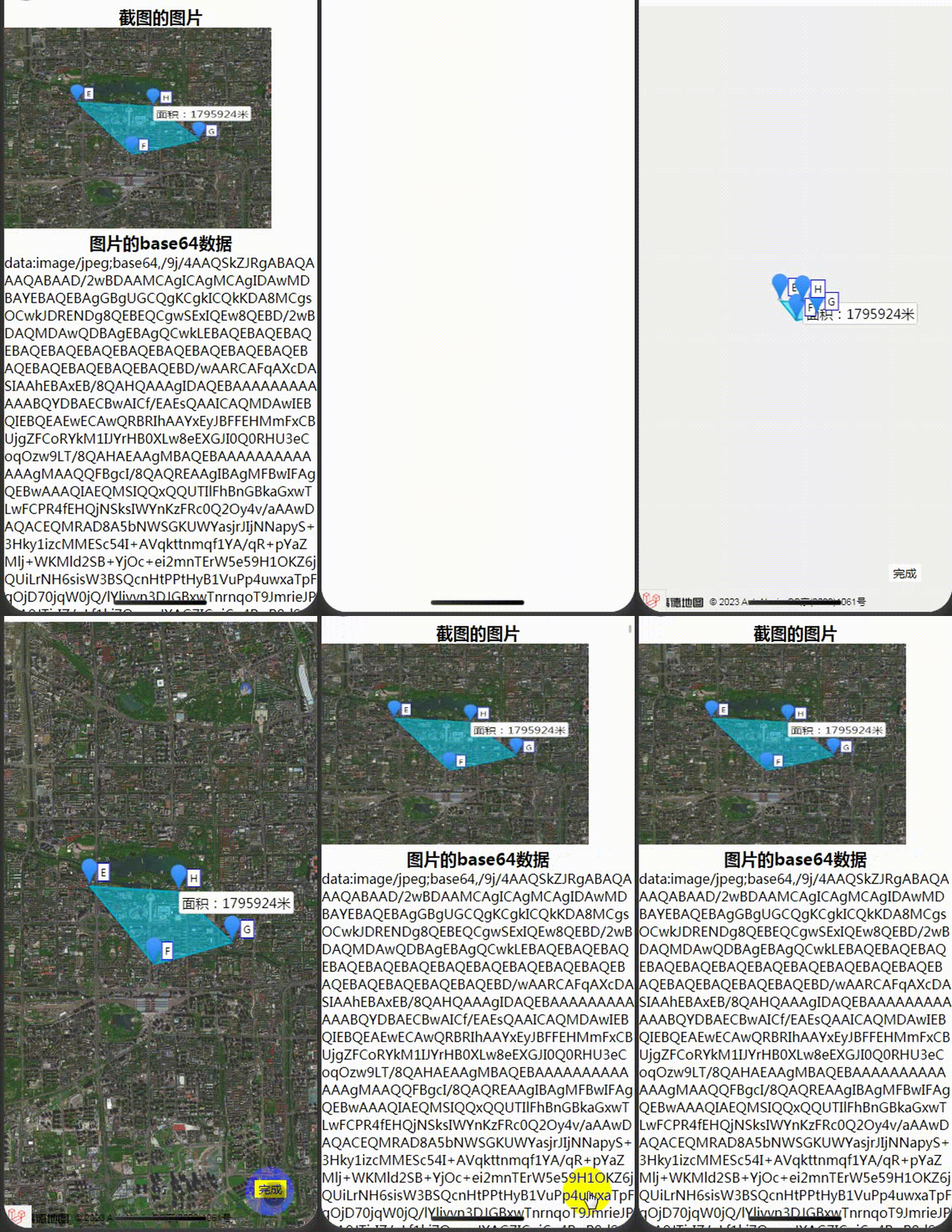
完成效果
感谢阅读,欢迎讨论
功能需求
打开页面展示卫星地图,用户自行在地图上绘制多边形并给每个点进行距离计算,完成多边形绘图后显示计算面积
使用的技术点
微信小程序的web-view
官方文档:web-view | 微信开放文档
高德地图的地图JS API
官方文档:概述-地图 JS API 2.0 | 高德地图API
<!-- JS文件引入 -->
<!-- web-view的微信小程序js文件 -->
<script src="https://res.wx.qq.com/open/js/jweixin-1.3.2.js"></script>
<script src="https://cdn.bootcdn.net/ajax/libs/vue/2.6.14/vue.min.js"></script>
<script src="https://cdn.bootcdn.net/ajax/libs/html2canvas/1.4.1/html2canvas.min.js"></script>
<script src="https://webapi.amap.com/loader.js"></script>
注意点
1、web-view在个人小程序是不支持的,上线时需要在小程序后台设置开放web-view的request域名;
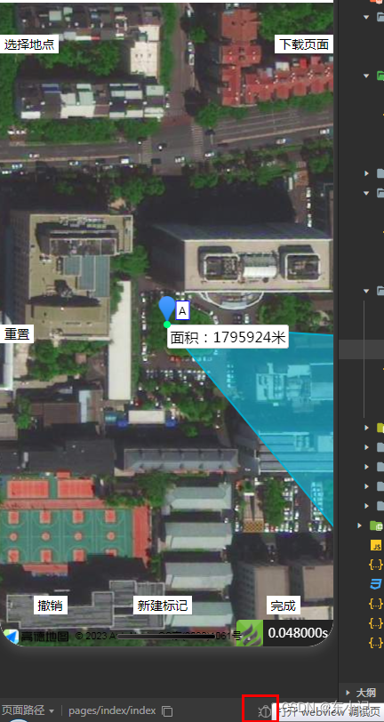
2、web-view如何在微信开发工具调试?
在模拟器的界面左下角栏目中,找到debug图标(小虫子),点击即可查看
3、高德地图的js api需要在高德开发者平台进行申请;
实现步骤
1、微信小程序页面定义web-view组件,在js文件中进行url的动态传入(url增加随机参数避免无刷新);
2、编写H5页面实现在高德卫星地图绘制多边形的功能;
3、H5触发完成动作发送数据包给微信小程序,微信小程序接收截图数据
代码
微信小程序-地图所在的wxml
<web-view wx:if="{{ url }}" src="{{url}}" bindload="loadWebView" binderror="errorWebView" bindmessage="messageWebView">
</web-view>
微信小程序-地图所在的js
Page({
  data: {
    latitude: '23.099994',
    longitude: '113.324520'
  },

  onLoad() {
      this.setData({url:'https://52381x1l37.zicp.fun/web/gaode?random=' + Math.random() + '#wechat_redirect'})
  },

  loadWebView(e) {
    console.log("加载web-view成功",e)
  },

  errorWebView(e) {
    console.log("加载web-view失败",e)
  },

  messageWebView(e) {
    console.log("web-view信息接收", e)
    // 记录base64的图片数据到缓存中,方便读取
    let h5Data = e.detail.data[0]
    if (h5Data.opera == 'finish') {
      wx.setStorageSync('finishBase64', h5Data.base64)
    }
  },
})
微信小程序-展示截图结果的wxml
<view>
  <view style="font-size: 20px;font-weight: bold;text-align: center;">截图的图片</view>
  <image src="{{src}}"></image>
  <view style="font-size: 20px;font-weight: bold;text-align: center;">图片的base64数据</view>
  <view style="word-break: break-all;width:100%;">{{base64Text}}</view>
</view>
微信小程序-展示截图结果的js
Page({
  /**
   * 页面的初始数据
   */
  data: {
    src: '',
    base64Text: '',
  },

  /**
   * 生命周期函数--监听页面加载
   */
  onLoad(options) {
    if (wx.getStorageSync('finishBase64')) {
      this.setData({
        src: wx.getStorageSync('finishBase64'),
        base64Text: wx.getStorageSync('finishBase64'),
      })
    }
  }
})
H5-地图所在的html
<!doctype html>
<html lang="en">
<head>
    <meta charset="UTF-8">
    <meta name="viewport"
          content="width=device-width, user-scalable=no, initial-scale=1.0, maximum-scale=1.0, minimum-scale=1.0">
    <meta http-equiv="X-UA-Compatible" content="ie=edge">
    <title>{{$title}}</title>
</head>
<style>
    body,html,#container {
        width: 100%;
        height: 100%;
        margin: 0;
    }
</style>
<body>
<div id="container"></div>
<div id="app">
    <div style="font-size:14px;background:#fff;color: black; padding: 1px 5px;position: fixed; bottom:5%;right:10%;"
         @click="clickFinishSign()">完成</div>
</div>
</body>
</html>
<!-- 微信小程序 -->
<script src="https://res.wx.qq.com/open/js/jweixin-1.3.2.js"></script>
<script src="https://cdn.bootcdn.net/ajax/libs/vue/2.6.14/vue.min.js"></script>
<script src="https://cdn.bootcdn.net/ajax/libs/html2canvas/1.4.1/html2canvas.min.js"></script>
<!-- 高德地图 -->
<script src="https://webapi.amap.com/loader.js"></script>
<script>

</script>
<script>
    let map = null
    new Vue({
        el: '#app',
        data: {},
        methods: {
            clickFinishSign() {
                console.log("clickFinishSign")
                wx.miniProgram.getEnv(function(res) {
                    console.log(res,'res')
                    if (res.miniprogram) {
                        setTimeout(function(){
                            let container = document.getElementById('container')
                            html2canvas(container, {
                                scale: 1,
                                useCORS: true,
                                allowTaint: true,
                                height: container.clientHeight / 2, // 设置画图的高度
                                width: container.clientWidth, // 设置画图的宽度
                                x: 0, // 设置画图开始的位置,X轴
                                y: container.clientHeight / 4, // 设置画图开始的位置,Y轴
                            }).then(canvas => {
                                let base64 = canvas.toDataURL('image/jpeg')
                                console.log("高度:"+container.clientWidth,"宽度:" + container.clientHeight, "图片:" + base64)
                                wx.miniProgram.postMessage({data: {base64: base64, opera: 'finish'}})
                                wx.miniProgram.redirectTo({url: '/pages/finish/finish'})
                            })
                        },1000)
                    } else {
                        alert("请在微信小程序进行此操作")
                    }
                })
            }
        },
        mounted() {
            // 设置地图的初始中心点
            let center = [116.308904,39.913423]
            AMapLoader.load({ //首次调用 load
                key: "{{$webJsApiKey}}",//首次load key为必填
                version:'2.0',
                plugins:['AMap.TileLayer.Satellite']
            }).then((AMap)=>{
                map = new AMap.Map('container', {
                    layers: [new AMap.TileLayer.Satellite()],
                    zoom: 10,
                    zooms: [10, 25], // 控制缩放范围
                    center: center, // 地图中心点
                    WebGLParams: {preserveDrawingBuffer: true} // 设置允许截取高德地图图片内容
                });

                let o = new AMap.Polygon({map: map, path: [
                        new AMap.LngLat(116.308904,39.913423),
                        new AMap.LngLat(116.322122,39.901176),
                        new AMap.LngLat(116.338258,39.904600),
                        new AMap.LngLat(116.327271,39.912501),

                    ]})
                var area = Math.round(AMap.GeometryUtil.ringArea(o.getPath()))
                var text = new AMap.Text({
                    position: new AMap.LngLat(116.327271,39.912501),
                    text: '面积:' + area + '米',
                })
                map.add(text)
                let markers = [
                    [
                        new AMap.Marker({label: {content: 'E'}, position: new AMap.LngLat(116.308904,39.913423), map: map}),
                        new AMap.Marker({label: {content: 'F'}, position: new AMap.LngLat(116.322122,39.901176), map: map}),
                        new AMap.Marker({label: {content: 'G'}, position: new AMap.LngLat(116.338258,39.904600), map: map}),
                        new AMap.Marker({label: {content: 'H'}, position: new AMap.LngLat(116.327271,39.912501), map: map})
                    ],
                ];
                map.add(markers)
                map.setFitView() // 自适应显示标记的图案
            }).catch((e)=>{
                console.error(e);
            });
        }
    })
</script>
完成效果
