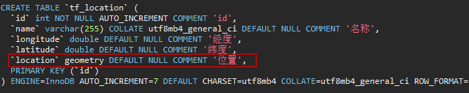
1.创建表
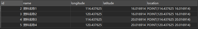
2.插入表数据
INSERT INTO `tf_sys`.`tf_location`(`name`, `longitude`, `latitude`, `location`) VALUES ('资料名称1', 114.437625, 16.016914, ST_GeomFromText('POINT(114.437625 16.016914)'));
INSERT INTO `tf_sys`.`tf_location`(`name`, `longitude`, `latitude`, `location`) VALUES ('资料名称2', 120.437625, 16.016914, ST_GeomFromText('POINT(120.437625 16.016914)'));
INSERT INTO `tf_sys`.`tf_location`(`name`, `longitude`, `latitude`, `location`) VALUES ('资料名称3', 114.437625, 20.016914, ST_GeomFromText('POINT(114.437625 20.016914)'));
INSERT INTO `tf_sys`.`tf_location`(`name`, `longitude`, `latitude`, `location`) VALUES ('资料名称4', 120.437625, 20.016914, ST_GeomFromText('POINT(120.437625 20.016914)'));
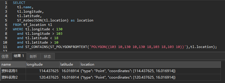
3.查询
3.1 sql
SELECT
	tl.name,
	tl.longitude,
	tl.latitude,
	ST_AsGeoJSON(tl.location) as location
FROM tf_location tl
WHERE tl.longitude < 130
	and tl.longitude > 103
	and tl.latitude < 18
	and tl.latitude > 10
	and ST_CONTAINS(ST_POLYGONFROMTEXT('POLYGON((103 10,130 10,130 18,103 18,103 10))'),tl.location);
3.2 语句
SELECT
    tl.id,
    tl.name,
    tl.longitude,
    tl.latitude,
    ST_AsGeoJSON(tl.location) as location
FROM tf_location tl
	WHERE tl.longitude < #{maxLong}
      and tl.longitude > #{minLong}
      and tl.latitude < #{maxLat}
      and tl.latitude > #{minLat}
      and ST_CONTAINS(ST_POLYGONFROMTEXT(#{polygon}), tl.location)
3.3 解释
① 几何图形需要形成一个闭合区域
② 获取集合图形经纬度的最大值和最小值
③ POLYGON((103 10,130 10,130 18,103 18,103 10)),按瞬时间填写经纬度,并且第一个和最后一个的值保持一样形成一个闭合的区域


![[Linux系统编程]进程间通信—system V](https://i-blog.csdnimg.cn/direct/8854f8b0b2d849ce958e71f6b9f059eb.png)