1.准备工作
高德开发API注册账号,创建项目拿到key和密钥
高德key
2.通过JS API引入高德API
<html>
  <head>
    <meta charset="utf-8" />
    <meta http-equiv="X-UA-Compatible" content="IE=edge" />
    <meta
      name="viewport"
      content="initial-scale=1.0, user-scalable=no, width=device-width"
    />
    <title>HELLO,AMAP!</title>
    <style>
      html,
      body,
      #container {
        width: 100%;
        height: 100%;
      }
    </style>
     <script type="text/javascript">
        window._AMapSecurityConfig = {
          securityJsCode: "「你申请的安全密钥」",
        };
      </script>
      <script src="https://webapi.amap.com/loader.js"></script>
      <script type="text/javascript">
        AMapLoader.load({
          key: "「你申请的应用Key」", //申请好的Web端开发者 Key,调用 load 时必填
          version: "2.0", //指定要加载的 JS API 的版本,缺省时默认为 1.4.15
        })
          .then((AMap) => {
               //JS API 加载完成后获取AMap对象
          .catch((e) => {
            console.error(e); //加载错误提示
          });
      </script>
  </head>
  <body>
    <div id="container"></div>
  </body>
</html>
3.展示地图
<!DOCTYPE html>
<html>
  <head>
    <meta charset="utf-8" />
    <meta http-equiv="X-UA-Compatible" content="IE=edge" />
    <meta
      name="viewport"
      content="initial-scale=1.0, user-scalable=no, width=device-width"
    />
    <title>HELLO,AMAP!</title>
    <style>
      html,
      body,
      #container {
        width: 100%;
        height: 100%;
      }
    </style>
     <script type="text/javascript">
        window._AMapSecurityConfig = {
          securityJsCode: "「你申请的安全密钥」",
        };
      </script>
      <script src="https://webapi.amap.com/loader.js"></script>
      <script type="text/javascript">
        AMapLoader.load({
          key: "「你申请的应用Key」", //申请好的Web端开发者 Key,调用 load 时必填
          version: "2.0", //指定要加载的 JS API 的版本,缺省时默认为 1.4.15
        })
          .then((AMap) => {
               //JS API 加载完成后获取AMap对象
                const map = new AMap.Map("container", {
                    viewMode: '3D', // 默认使用 2D 模式,如果希望使用带有俯仰角的 3D 模式,请设置 viewMode: '3D'
                    zoom: 18, // 初始化地图层级
                    center: [116.397428, 39.90923], // 初始化地图中心点,
                });
          .catch((e) => {
            console.error(e); //加载错误提示
          });
      </script>
  </head>
  <body>
    <div id="container"></div>
  </body>
</html>
4.展示图层
<!DOCTYPE html>
<html>
  <head>
    <meta charset="utf-8" />
    <meta http-equiv="X-UA-Compatible" content="IE=edge" />
    <meta
      name="viewport"
      content="initial-scale=1.0, user-scalable=no, width=device-width"
    />
    <title>HELLO,AMAP!</title>
    <style>
      html,
      body,
      #container {
        width: 100%;
        height: 100%;
      }
    </style>
     <script type="text/javascript">
        window._AMapSecurityConfig = {
          securityJsCode: "「你申请的安全密钥」",
        };
      </script>
      <script src="https://webapi.amap.com/loader.js"></script>
      <script type="text/javascript">
        AMapLoader.load({
          key: "「你申请的应用Key」", //申请好的Web端开发者 Key,调用 load 时必填
          version: "2.0", //指定要加载的 JS API 的版本,缺省时默认为 1.4.15
        })
          .then((AMap) => {
               //JS API 加载完成后获取AMap对象
              //1.2 创建图层
                const layer = new AMap.createDefaultLayer({
                    zooms: [3, 20], //可见级别
                    visible: true, //是否可见
                    opacity: 1, //透明度
                    zIndex: 0, //叠加层级
                });
                const map = new AMap.Map("container", {
                    viewMode: '3D', // 默认使用 2D 模式,如果希望使用带有俯仰角的 3D 模式,请设置 viewMode: '3D'
                    zoom: 18, // 初始化地图层级
                    center: [116.397428, 39.90923], // 初始化地图中心点,
                    //1.3 加载图层
                    layers: [layer], //layer为创建的默认图层
                });
                //1.4 创建实时交通路况图层
                const traffic = new AMap.TileLayer.Traffic({
                    autoRefresh: true, //是否自动刷新,默认为false
                    interval: 180, //刷新间隔,默认180s
                });
                map.add(traffic); //通过add方法添加图层
               // map.remove(traffic)//通过remove方法删除图层
          .catch((e) => {
            console.error(e); //加载错误提示
          });
      </script>
  </head>
  <body>
    <button></button>
    <div id="container"></div>
  </body>
</html>
5.地图控件
<!DOCTYPE html>
<html>
  <head>
    <meta charset="utf-8" />
    <meta http-equiv="X-UA-Compatible" content="IE=edge" />
    <meta
      name="viewport"
      content="initial-scale=1.0, user-scalable=no, width=device-width"
    />
    <title>HELLO,AMAP!</title>
    <style>
      html,
      body,
      #container {
        width: 100%;
        height: 100%;
      }
    </style>
     <script type="text/javascript">
        window._AMapSecurityConfig = {
          securityJsCode: "「你申请的安全密钥」",
        };
      </script>
      <script src="https://webapi.amap.com/loader.js"></script>
      <script type="text/javascript">
        AMapLoader.load({
          key: "「你申请的应用Key」", //申请好的Web端开发者 Key,调用 load 时必填
          version: "2.0", //指定要加载的 JS API 的版本,缺省时默认为 1.4.15
        })
          .then((AMap) => {
               //JS API 加载完成后获取AMap对象
                const map = new AMap.Map("container", {
                    viewMode: '3D', // 默认使用 2D 模式,如果希望使用带有俯仰角的 3D 模式,请设置 viewMode: '3D'
                    zoom: 18, // 初始化地图层级
                    center: [116.397428, 39.90923], // 初始化地图中心点,
                    pitch:45,//初始地图俯仰角度
                });

               // 5.1引入地图控制
               //异步加载方式,在需要的地方引入。通过AMap.plugin方法按需引入控件,在plugin回调之后使用控件功能。
               AMap.plugin(['AMap.ToolBar','AMap.Scale','AMap.HawkEye','AMap.MapType','AMap.ControlBar'],function () {
                    //ToolBar:集成了缩放,平移,定位
                    var toolbar = new AMap.ToolBar(); //缩放工具条实例化
                    var Scale = new AMap.Scale(); //比例尺
                    var HawkEye = new AMap.HawkEye(); //鹰眼
                    var MapType = new AMap.MapType(); //地图类型
                    var ControlBar = new AMap.ControlBar();//
                    //5.2添加控件
                    map.addControl(toolbar);//缩放工具
                    map.addControl(Scale);//Scale(比例尺):展示地图在当前层级和经纬度下的比例
                    map.addControl(HawkEye);//HawkEye(鹰眼):右下角地图的缩略图
                    map.addControl(MapType);
                    map.addControl(ControlBar);//ControlBar 方向盘
                });

          .catch((e) => {
            console.error(e); //加载错误提示
          });
      </script>
  </head>
  <body>
    <div id="container"></div>
  </body>
</html>
6.地图事件
6.1获取经纬度
<!DOCTYPE html>
<html>
  <head>
    <meta charset="utf-8" />
    <meta http-equiv="X-UA-Compatible" content="IE=edge" />
    <meta
      name="viewport"
      content="initial-scale=1.0, user-scalable=no, width=device-width"
    />
    <title>HELLO,AMAP!</title>
    <style>
      html,
      body,
      #container {
        width: 100%;
        height: 100%;
      }
    </style>
     <script type="text/javascript">
        window._AMapSecurityConfig = {
          securityJsCode: "「你申请的安全密钥」",
        };
      </script>
      <script src="https://webapi.amap.com/loader.js"></script>
      <script type="text/javascript">
        AMapLoader.load({
          key: "「你申请的应用Key」", //申请好的Web端开发者 Key,调用 load 时必填
          version: "2.0", //指定要加载的 JS API 的版本,缺省时默认为 1.4.15
        })
          .then((AMap) => {
               //JS API 加载完成后获取AMap对象
                const map = new AMap.Map("container", {
                    viewMode: '3D', // 默认使用 2D 模式,如果希望使用带有俯仰角的 3D 模式,请设置 viewMode: '3D'
                    zoom: 18, // 初始化地图层级
                    center: [116.397428, 39.90923], // 初始化地图中心点,
                });
                //6.1监听地图的点击事件
                map.on('click',function(event){
                //获取经纬度
                console.log(`经度:${event.lnglat.lng},纬度:${event.lnglat.lat}`)
                })
          .catch((e) => {
            console.error(e); //加载错误提示
          });
      </script>
  </head>
  <body>
    <div id="container"></div>
  </body>
</html>
7.点标记
比如省会城市会有Mark标注
<!DOCTYPE html>
<html>
  <head>
    <meta charset="utf-8" />
    <meta http-equiv="X-UA-Compatible" content="IE=edge" />
    <meta
      name="viewport"
      content="initial-scale=1.0, user-scalable=no, width=device-width"
    />
    <title>HELLO,AMAP!</title>
    <style>
      html,
      body,
      #container {
        width: 100%;
        height: 100%;
      }
      //7.3自定义样式
       .custom-content-marker {
            position: relative;
            width: 25px;
            height: 34px;
        }

        .custom-content-marker img {
            width: 100%;
            height: 100%;
        }

        .custom-content-marker .close-btn {
            position: absolute;
            top: -6px;
            right: -8px;
            width: 15px;
            height: 15px;
            font-size: 12px;
            background: #ccc;
            border-radius: 50%;
            color: #fff;
            text-align: center;
            line-height: 15px;
            box-shadow: -1px 1px 1px rgba(10, 10, 10, .2);
        }

        .custom-content-marker .close-btn:hover {
            background: #666;
        }
    </style>
     <script type="text/javascript">
        window._AMapSecurityConfig = {
          securityJsCode: "「你申请的安全密钥」",
        };
      </script>
      <script src="https://webapi.amap.com/loader.js"></script>
      <script type="text/javascript">
        AMapLoader.load({
          key: "「你申请的应用Key」", //申请好的Web端开发者 Key,调用 load 时必填
          version: "2.0", //指定要加载的 JS API 的版本,缺省时默认为 1.4.15
        })
          .then((AMap) => {
                 //7.1创建地图
                const map = new AMap.Map("container", {
                    viewMode: '2D', // 默认使用 2D 模式,如果希望使用带有俯仰角的 3D 模式,请设置 viewMode: '3D'
                    zoom: 18, // 初始化地图层级
                    center: [116.397428, 39.90923], // 初始化地图中心点,
                });
                //7.2自定义Marker点标记显示内容
                const markerContent = `<div class="custom-content-marker">
<img src="https://a.amap.com/lbs/static/img/doc/doc_1678970777168_d2b5c.png">
<div class="close-btn" οnclick="clearMarker()">X</div>
</div>`
                //7.4创建Marker对象
                const position = new AMap.LngLat(116.397428, 39.90923); //Marke经纬度
                const marker = new AMap.Marker({
                    position: position,
                    content: markerContent, //将 html 传给 content
                    offset: new AMap.Pixel(-13, -30), //以 icon 的 [center bottom] 为原点
                });
                //7.5将Marker添加到地图上
                map.add(marker);
                //7.6给 Marker 绑定事件
                function clearMarker() {
                    map.remove(marker); //清除 marker
                }
                document.querySelector(".close-btn").onclick = clearMarker; //绑定点击事件
              })
          .catch((e) => {
            console.error(e); //加载错误提示
          });
      </script>
  </head>
  <body>
    <div id="container"></div>
  </body>
</html>
8.交互式绘制点
<!DOCTYPE html>
<html>
  <head>
    <meta charset="utf-8" />
    <meta http-equiv="X-UA-Compatible" content="IE=edge" />
    <meta
      name="viewport"
      content="initial-scale=1.0, user-scalable=no, width=device-width"
    />
    <title>HELLO,AMAP!</title>
    <style>
      html,
      body,
      #container {
        width: 100%;
        height: 100%;
      }
      //7.3自定义样式
       .custom-content-marker {
            position: relative;
            width: 25px;
            height: 34px;
        }

        .custom-content-marker img {
            width: 100%;
            height: 100%;
        }

        .custom-content-marker .close-btn {
            position: absolute;
            top: -6px;
            right: -8px;
            width: 15px;
            height: 15px;
            font-size: 12px;
            background: #ccc;
            border-radius: 50%;
            color: #fff;
            text-align: center;
            line-height: 15px;
            box-shadow: -1px 1px 1px rgba(10, 10, 10, .2);
        }

        .custom-content-marker .close-btn:hover {
            background: #666;
        }
    </style>
     <script type="text/javascript">
        window._AMapSecurityConfig = {
          securityJsCode: "「你申请的安全密钥」",
        };
      </script>
      <script src="https://webapi.amap.com/loader.js"></script>
      <script type="text/javascript">
        AMapLoader.load({
          key: "「你申请的应用Key」", //申请好的Web端开发者 Key,调用 load 时必填
          version: "2.0", //指定要加载的 JS API 的版本,缺省时默认为 1.4.15
        })
          .then((AMap) => {
                 //7.1创建地图
                const map = new AMap.Map("container", {
                    viewMode: '2D', // 默认使用 2D 模式,如果希望使用带有俯仰角的 3D 模式,请设置 viewMode: '3D'
                    zoom: 18, // 初始化地图层级
                    center: [116.397428, 39.90923], // 初始化地图中心点,
                });
                //7.2自定义Marker点标记显示内容
                const markerContent = `<div class="custom-content-marker">
<img src="https://a.amap.com/lbs/static/img/doc/doc_1678970777168_d2b5c.png">
<div class="close-btn" οnclick="clearMarker()">X</div>
</div>`
                map.on('click', function (e) {
                    //7.3创建Marker对象
                    const marker = new AMap.Marker({
                        position: e.lnglat,
                        content: markerContent, //将 html 传给 content
                        offset: new AMap.Pixel(-13, -30), //以 icon 的 [center bottom] 为原点
                    });
                    //7.4将Marker添加到地图上
                    map.add(marker);
                })
              })
          .catch((e) => {
            console.error(e); //加载错误提示
          });
      </script>
  </head>
  <body>
    <div id="container"></div>
  </body>
</html>
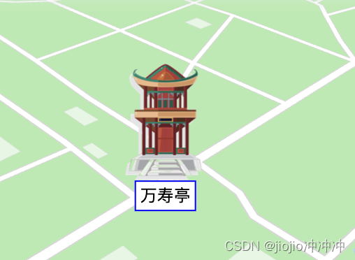
9.灵活点标记
<!DOCTYPE html>
<html>

<head>
    <meta charset="utf-8" />
    <meta http-equiv="X-UA-Compatible" content="IE=edge" />
    <meta name="viewport" content="initial-scale=1.0, user-scalable=no, width=device-width" />
    <title>HELLO,AMAP!</title>
    <style>
        html,
        body,
        #container {
            width: 90%;
            height: 90%;
        }

    </style>
    <script type="text/javascript">
        window._AMapSecurityConfig = {
            securityJsCode: "",
        };
    </script>
    <script src="https://webapi.amap.com/loader.js"></script>
    <script type="text/javascript">
        AMapLoader.load({
            key: "", //申请好的Web端开发者 Key,调用 load 时必填
            version: "2.0", //指定要加载的 JS API 的版本,缺省时默认为 1.4.15
        })
            .then((AMap) => {
                //7.1创建地图
                const map = new AMap.Map("container", {
                    viewMode: '3D',
                    turboMode: false,
                    showIndoorMap: false,
                    defaultCursor: 'pointer',
                    showBuildingBlock: false,
                    zooms: [14, 20],
                    showLabel: false,
                    zoom: 16,
                    pitch: 55,
                    rotation: -45,
                    center: [116.408967, 39.880101],
                    forceVector: true,
                });
                //9.1 创建样式列表
                var stylesArray = [
                    {
                        icon: { //图标样式
                            img: "https://a.amap.com/jsapi_demos/static/resource/img/men3.png",
                            size: [16, 16], //图标的原始大小
                            anchor: "bottom-center", //锚点位置
                            fitZoom: 14, //最合适的级别 在此级别显示为图标原始大小
                            scaleFactor: 2, //地图放大一级的缩放比例系数
                            maxScale: 2, //图片的最大放大比例,随着地图放大图标会跟着放大,最大为2
                            minScale: 1, //图片的最小缩小比例,随着地图缩小图标会跟着缩小,最小为1
                        },
                        label: { //文本标注
                            content: "百花殿", //文本内容
                            position: "BM", //文本位置相对于图标的基准点,"BM"为底部中央
                            minZoom: 15, //label的最小显示级别,即文本标注在地图15级及以上,才会显示
                        },
                    },
                    {
                        icon: {
                            img: "https://a.amap.com/jsapi_demos/static/resource/img/tingzi.png",
                            size: [48, 63],
                            anchor: "bottom-center",
                            fitZoom: 17.5,
                            scaleFactor: 2,
                            maxScale: 2,
                            minScale: 0.125,
                        },
                        label: {
                            content: "万寿亭",
                            position: "BM",
                            minZoom: 15,
                        },
                    },
                ];
                //9.2 创建样式列表的级别映射
                var zoomStyleMapping = {
                    14: 0, //14-17级使用样式 0
                    15: 0,
                    16: 0,
                    17: 0,
                    18: 1, //18-20级使用样式 1
                    19: 1,
                    20: 1,
                };
                // 9.3 加载灵活点标记的插件
                AMap.plugin(["AMap.ElasticMarker"], function () {
                    var elasticMarker = new AMap.ElasticMarker({
                        position: [116.405562, 39.881166], //点标记位置
                        styles: stylesArray, //指定样式列表
                        zoomStyleMapping: zoomStyleMapping, //指定 zoom 与样式的映射
                    });
                    map.add(elasticMarker); //添加到地图上
                    map.setFitView(); //缩放地图到合适的视野级别
                });
            })
            .catch((e) => {
                console.error(e); //加载错误提示
            });

    </script>
</head>

<body>

    <div id="container"></div>
</body>

</html>
10.矢量图形
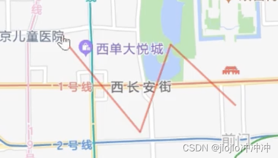
10.1折线
<!DOCTYPE html>
<html>
<head>
    <meta charset="utf-8" />
    <meta http-equiv="X-UA-Compatible" content="IE=edge" />
    <meta name="viewport" content="initial-scale=1.0, user-scalable=no, width=device-width" />
    <title>HELLO,AMAP!</title>
    <style>
        html,
        body,
        #container {
            width: 90%;
            height: 90%;
        }
    </style>
    <script type="text/javascript">
        window._AMapSecurityConfig = {
            securityJsCode: "",
        };
    </script>
    <script src="https://webapi.amap.com/loader.js"></script>
    <script type="text/javascript">
        AMapLoader.load({
            key: "", //申请好的Web端开发者 Key,调用 load 时必填
            version: "2.0", //指定要加载的 JS API 的版本,缺省时默认为 1.4.15
        })
            .then((AMap) => {
                //10.1创建地图
                const map = new AMap.Map("container", {
                    zoom: 10, //地图级别
                    center: [116.397428, 39.90923], //地图中心点
                    viewMode: "2D", //地图模式
                });
                //10.2 折线的节点配置折线路径
                var path = [
                    new AMap.LngLat(116.368904, 39.913423),
                    new AMap.LngLat(116.382122, 39.901176),
                    new AMap.LngLat(116.387271, 39.912501),
                    new AMap.LngLat(116.398258, 39.9046),
                ];
                // 10.3 创建折线 Polyline 实例
                //创建 Polyline 实例
                var polyline = new AMap.Polyline({
                    path: path,
                    strokeWeight: 2, //线条宽度
                    strokeColor: "red", //线条颜色
                    lineJoin: "round", //折线拐点连接处样式
                });
                //1.4 将折线添加至地图实例
                map.add(polyline);
            })
            .catch((e) => {
                console.error(e); //加载错误提示
            });

    </script>
</head>

<body>
    <div id="container"></div>
</body>

</html>
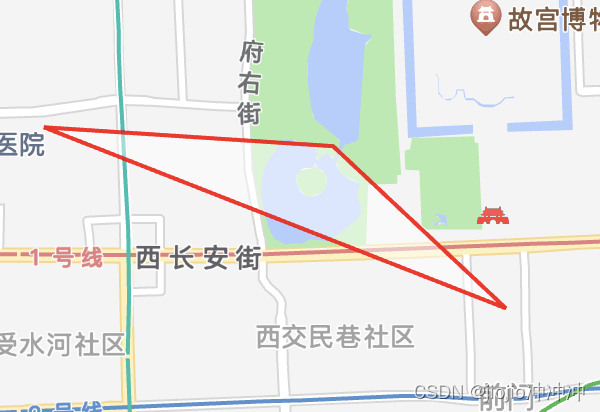
10.2多边形polygon
<!DOCTYPE html>
<html>

<head>
    <meta charset="utf-8" />
    <meta http-equiv="X-UA-Compatible" content="IE=edge" />
    <meta name="viewport" content="initial-scale=1.0, user-scalable=no, width=device-width" />
    <title>HELLO,AMAP!</title>
    <style>
        html,
        body,
        #container {
            width: 90%;
            height: 90%;
        }
    </style>
    <script type="text/javascript">
        window._AMapSecurityConfig = {
            securityJsCode: "",
        };
    </script>
    <script src="https://webapi.amap.com/loader.js"></script>
    <script type="text/javascript">
        AMapLoader.load({
            key: "", //申请好的Web端开发者 Key,调用 load 时必填
            version: "2.0", //指定要加载的 JS API 的版本,缺省时默认为 1.4.15
        })
            .then((AMap) => {
                //10.1创建地图
                const map = new AMap.Map("container", {
                    zoom: 8.8, //地图级别
                    center: [116.397428, 39.90923], //地图中心点
                    viewMode: "2D", //地图模式
                });
                //10.2 设置多边形轮廓线的节点坐标数组
                //多边形轮廓线的节点坐标数组
                var path = [
                    new AMap.LngLat(116.368904, 39.913423),
                    new AMap.LngLat(116.387271, 39.912501),
                    new AMap.LngLat(116.398258, 39.9046),
                ];
                // 10.3  创建多边形 Polygon 实例
                //创建 Polyline 实例
                //创建多边形 Polygon 实例
                var polygon = new AMap.Polygon({
                    path: path, //路径
                    fillColor: "#fff", //多边形填充颜色
                    strokeWeight: 2, //线条宽度,默认为 2
                    strokeColor: "red", //线条颜色
                });
                //10.4 多边形 Polygon 对象添加到 Map
                //多边形 Polygon对象添加到 Map
                map.add(polygon);
                //将覆盖物调整到合适视野
                map.setFitView([polygon])
            })
            .catch((e) => {
                console.error(e); //加载错误提示
            });

    </script>
</head>

<body>

    <div id="container"></div>
</body>

</html>
11.计算距离

<!DOCTYPE html>
<html>
  <head>
    <meta charset="utf-8" />
    <meta http-equiv="X-UA-Compatible" content="IE=edge" />
    <meta
      name="viewport"
      content="initial-scale=1.0, user-scalable=no, width=device-width"
    />
    <title>HELLO,AMAP!</title>
    <style>
      html,
      body,
      #container {
        width: 100%;
        height: 100%;
      }
    </style>
     <script type="text/javascript">
        window._AMapSecurityConfig = {
          securityJsCode: "「你申请的安全密钥」",
        };
      </script>
      <script src="https://webapi.amap.com/loader.js"></script>
      <script type="text/javascript">
        AMapLoader.load({
          key: "「你申请的应用Key」", //申请好的Web端开发者 Key,调用 load 时必填
          version: "2.0", //指定要加载的 JS API 的版本,缺省时默认为 1.4.15
        })
          .then((AMap) => {
               //JS API 加载完成后获取AMap对象
               //11.1创建地图
                const map = new AMap.Map("container", {
                    viewMode: '2D', // 默认使用 2D 模式,如果希望使用带有俯仰角的 3D 模式,请设置 viewMode: '3D'
                    zoom: 18, // 初始化地图层级
                    center: [116.434027, 39.941037], // 初始化地图中心点,
                });
                //11.2创建两个点(设置可以拖动)
                 const m1 = new AMap.Marker({
                       map:map,//将m1这个点添加到map地图上
                       draggable:true,//配置该点可以拖动
                       position:new AMap.LngLat(116.434027, 39.941037)
                    });
                  const m2 = new AMap.Marker({
                       map:map,//将m2这个点添加到map地图上
                       draggable:true,//配置该点可以拖动
                       position:new AMap.LngLat(116.461665, 39.941564)
                    });
                  //让地图根据覆盖物调整地图显示区域
                  //11.3准备一条线
                  var line = new AMap.Polyline({
                     strokeColor:'#80d8ff',//描边的颜色
                     isOutline:true,//包含轮廓
                     outerlineColor:'white'
                  })
                  line.setMap(map)
                  //11.4准备文本
                  var text = new AMap.Text({
                     text:'',
                     style:{
                       'background-color':'#29b6f6',
                       'border-color': "#e1f5fe",
                        'font-size':'16px'
                     }
                  })
                  text.setMap(map)
                   //11.5计算
                   function compute(){
                     var p1 = m1.getPosition()
                     var p2 = m2.getPosition()
                     var textPos = p1.divideBy(2).add(p2.divideBy(2))
                     var distance = Math.round(p1.distance(p2))
                     var path = [p1,p2]
                     line.setPath(path)//绘制线,根据p1,p2起始点和终点的坐标
                     text.setText('距离为:'+distance+'米')
                     text.setPosition(textPos)
                   }
                   compute()
                   m1.on('dragging',compute)
                   m2.on('dragging',compute)
                  })

          .catch((e) => {
            console.error(e); //加载错误提示
          });
      </script>
  </head>
  <body>
    <div id="container"></div>
  </body>
</html>
12.GeoJSON
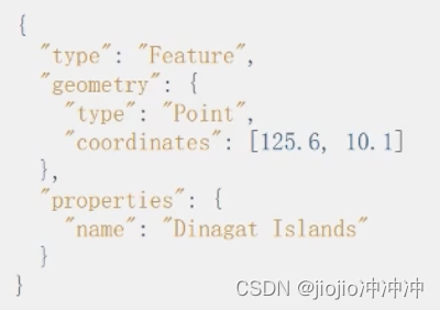
GeoJSON是一种保存地理信息的数据格式
包含几何信息和自定义属性
为什么使用GeoJSON
1️⃣数据持久化
地图上绘制了很多点, 刷新浏览器就没有了,绘制的点只是临时性的加载在地图中,这些数据是保存在内存中的,将数据保存到硬盘中这个过程叫数据持久化
2️⃣持久化
1.使用GDB数据库,将数据保存到地理数据库中
2.使用GeoJsON,将数据保存到 GeoJsoN 格式的文件中
对于小型应用,使用GeoJsON即可,相对于GDB更加方便简单
对于大型应用,更推荐GDB,功能更加强大,处理速度和效率更高

