引擎下载地址:[添加链接描述](http://support.supermap.com.cn/DownloadCenter/DownloadPage.aspx?id=2524)
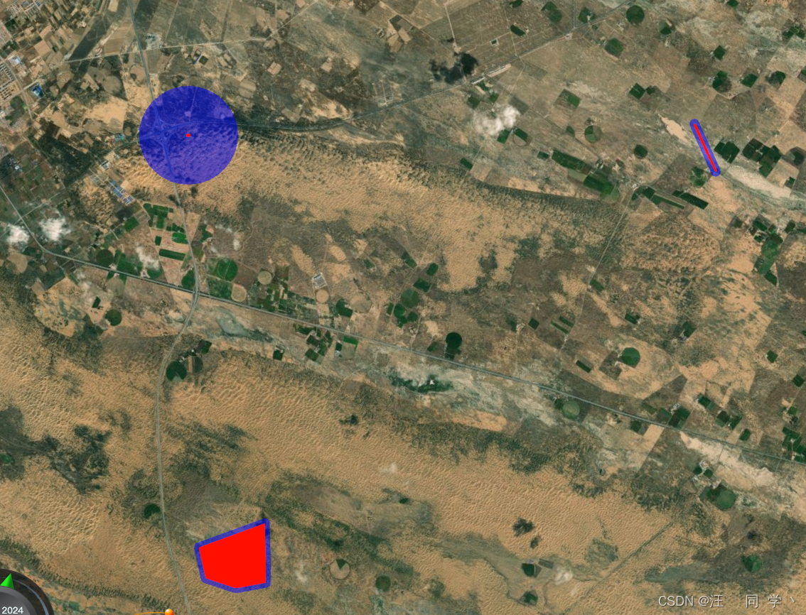
绘制缓冲区主要依赖[turfjs](https://turfjs.org/docs/#buffer)
先根据点线面的数据+turfjs计算得到缓冲区的坐标数据,再行绘制
<! DOCTYPE html > < htmllang = " en" > < head> < metacharset = " utf-8" > < metahttp-equiv = " X-UA-Compatible" content = " IE=Edge,chrome=1" > < metaname = " viewport" content = " width=device-width, initial-scale=1, maximum-scale=1, minimum-scale=1, user-scalable=no" > < title> </ title> < linkhref = " https://www.supermapol.com/webgl/Build/SuperMap3D/Widgets/widgets.css" rel = " stylesheet" > < linkhref = " https://www.supermapol.com/webgl/examples/webgl/css/pretty.css" rel = " stylesheet" > < linkhref = " https://www.supermapol.com/webgl/examples/webgl/style/colorCorrection.css" rel = " stylesheet" > < linkhref = " https://www.supermapol.com/webgl/examples/webgl/css/bootstrap-select.min.css" rel = " stylesheet" > < scriptsrc = " https://www.supermapol.com/webgl/examples/webgl/js/jquery.min.js" > </ script> < scriptsrc = " https://www.supermapol.com/webgl/examples/webgl/js/bootstrap.min.js" > </ script> < scriptsrc = " https://www.supermapol.com/webgl/examples/webgl/js/bootstrap-select.min.js" > </ script> < scriptsrc = " https://www.supermapol.com/webgl/examples/webgl/js/tooltip.js" > </ script> < scriptsrc = " https://www.supermapol.com/webgl/examples/webgl/js/slider.js" > </ script> < scriptsrc = " https://www.supermapol.com/webgl/examples/webgl/js/config.js" > </ script> < scripttype = " text/javascript" src = " https://www.supermapol.com/webgl/Build/SuperMap3D/SuperMap3D.js" > </ script> < linkrel = " stylesheet" href = " https://www.supermapol.com/webgl/web/libs/bootstrap/css/bootstrap.min.css" > < linkhref = " https://www.supermapol.com/webgl/examples/webgl/style/flood.css" rel = " stylesheet" > < scriptsrc = " https://unpkg.com/@turf/turf/turf.min.js" > </ script> < style>
.circle {
position : fixed;
left : 100px;
top : 100px;
}
.circle.active {
color : red;
}
.custom-panel {
position : fixed;
left : -1000px;
top : -1000px;
z-index : 1;
border-radius : 10px;
display : none;
color : #fff;
background-color : rgba ( 0, 0, 0, 0.3) ;
}
.tips {
position : fixed;
left : 100px;
top : 200px;
color : #fff;
}
input {
color : #000;
}
</ style> </ head> < body> < divid = " Container" > </ div> < scripttype = " text/javascript" >
let viewer, handler
const initMouseOperate = { }
const customPanel = document. querySelector ( '.custom-panel' )
const circle = document. querySelector ( '.circle' )
function onload ( SuperMap3D ) {
var EngineType = getEngineType ( )
viewer = new SuperMap3D. Viewer ( 'Container' , {
navigation : false ,
animation : true ,
contextOptions : {
contextType : Number ( 2 )
}
} )
viewer. scenePromise. then ( function ( scene ) {
init ( SuperMap3D, scene, viewer)
eventHandler ( )
drawPointBufferHandler ( )
drawLineBufferHandler ( )
drawPolygonBufferHandler ( )
setTimeout ( ( ) => {
flyTo ( {
x : - 1520391.2517026903 ,
y : 4801874.506984832 ,
z : 3926626.7742098756 ,
heading : 0.24220323846765268 ,
pitch : - 1.570572787555335 ,
roll : 0 ,
duration : 2
} )
} , 2000 ) ;
} )
}
function init ( SuperMap3D, scene, viewer ) {
viewer. imageryLayers. addImageryProvider ( new SuperMap3D. BingMapsImageryProvider ( {
url : 'https://dev.virtualearth.net' ,
mapStyle : SuperMap3D. BingMapsStyle. AERIAL ,
key : URL_CONFIG . BING_MAP_KEY
} ) )
}
function eventHandler ( ) {
handler = new SuperMap3D. ScreenSpaceEventHandler ( viewer. scene. canvas)
handler. setInputAction ( ( e ) => {
const panelPosition = viewer. scene. pickPosition ( e. position)
console. log ( panelPosition) ;
} , SuperMap3D. ScreenSpaceEventType. LEFT_CLICK )
}
function drawPointBufferHandler ( ) {
const point = viewer. entities. add ( {
point : {
color : new SuperMap3D. Color ( 255 , 0 , 0 , 255 ) ,
pixelSize : 2
} ,
position : { x : - 1512322.4558270602 , y : 4787938.387670586 , z : 3919903.201159994 } ,
disableDepthTestDistance : Number. POSITIVE_INFINITY
} )
const latlng = turf. point ( convertion1 ( { x : - 1512322.4558270602 , y : 4787938.387670586 , z : 3919903.201159994 } ) )
const buffered = turf. buffer ( latlng, 1 , { units : 'kilometers' } ) ;
const result = [ ]
buffered. geometry. coordinates[ 0 ] . forEach ( c => {
result. push ( convertion2 ( c[ 0 ] , c[ 1 ] ) )
} )
viewer. entities. add ( {
polygon : {
hierarchy : result,
material : new SuperMap3D. StripeMaterialProperty ( {
evenColor : SuperMap3D. Color. BLUE . withAlpha ( 0.5 ) ,
oddColor : SuperMap3D. Color. BLUE . withAlpha ( 0.5 ) ,
offset : 0.0 ,
repeat : 5.0
} )
}
} )
}
function drawLineBufferHandler ( ) {
const poss = [
{ x : - 1522237.9046121538 , y : 4786234.572753863 , z : 3918152.515072906 } ,
{ x : - 1522612.688882305 , y : 4786790.672703787 , z : 3917332.84709323 }
]
const line = viewer. entities. add ( {
polyline : {
positions : poss,
material : SuperMap3D. Color. RED ,
width : 3
} ,
disableDepthTestDistance : Number. POSITIVE_INFINITY
} )
const latlngs = [ ]
poss. forEach ( ( c ) => {
latlngs. push ( convertion1 ( c) )
} )
const polyline = turf. lineString ( latlngs)
const buffered = turf. buffer ( polyline, 100 / 1000 , { units : 'kilometers' } ) ;
const result = [ ]
buffered. geometry. coordinates[ 0 ] . forEach ( c => {
result. push ( convertion2 ( c[ 0 ] , c[ 1 ] ) )
} )
viewer. entities. add ( {
polygon : {
hierarchy : result,
material : new SuperMap3D. StripeMaterialProperty ( {
evenColor : SuperMap3D. Color. BLUE . withAlpha ( 0.5 ) ,
oddColor : SuperMap3D. Color. BLUE . withAlpha ( 0.5 ) ,
offset : 0.0 ,
repeat : 5.0
} )
}
} )
}
function drawPolygonBufferHandler ( ) {
const poss = [
{ x : - 1512123.7645718136 , y : 4793263.7218275955 , z : 3913503.8097187434 } ,
{ x : - 1513447.674567177 , y : 4792746.065483553 , z : 3913627.80841923 } ,
{ x : - 1513407.4898382805 , y : 4793516.069820738 , z : 3912703.06333416 } ,
{ x : - 1512816.7021667513 , y : 4793679.2934803255 , z : 3912731.690398276 } ,
{ x : - 1512231.997214621 , y : 4793643.150004599 , z : 3913000.318535814 } ,
{ x : - 1512123.7645718136 , y : 4793263.7218275955 , z : 3913503.8097187434 }
]
const polygon = viewer. entities. add ( {
polygon : {
hierarchy : poss,
material : new SuperMap3D. StripeMaterialProperty ( {
evenColor : SuperMap3D. Color. RED ,
oddColor : SuperMap3D. Color. RED ,
offset : 0.0 ,
repeat : 5.0
} )
}
} )
const latlngs = [ ]
poss. forEach ( ( c ) => {
latlngs. push ( convertion1 ( c) )
} )
const polygonLatlng = turf. polygon ( [ latlngs] )
const buffered = turf. buffer ( polygonLatlng, 100 / 1000 , { units : 'kilometers' } ) ;
const result = [ ]
buffered. geometry. coordinates[ 0 ] . forEach ( c => {
result. push ( convertion2 ( c[ 0 ] , c[ 1 ] ) )
} )
viewer. entities. add ( {
polygon : {
hierarchy : result,
material : new SuperMap3D. StripeMaterialProperty ( {
evenColor : SuperMap3D. Color. BLUE . withAlpha ( 0.5 ) ,
oddColor : SuperMap3D. Color. BLUE . withAlpha ( 0.5 ) ,
offset : 0.0 ,
repeat : 5.0
} )
}
} )
}
function convertion1 ( { x, y, z } ) {
const ellipsoid = viewer. scene. globe. ellipsoid
const cartesian3 = new SuperMap3D. Cartesian3 ( x, y, z)
const cartographic = ellipsoid. cartesianToCartographic ( cartesian3)
const lat = SuperMap3D. Math. toDegrees ( cartographic. latitude)
const lon = SuperMap3D. Math. toDegrees ( cartographic. longitude)
const alt = cartographic. height
return [ lon, lat]
}
function convertion2 ( lat, lng ) {
return SuperMap3D. Cartesian3. fromDegrees ( lat, lng)
}
function flyTo ( viewParams ) {
const { x, y, z, heading, pitch, roll, duration } = viewParams
viewer. camera. flyTo ( {
destination : new SuperMap3D. Cartesian3 ( x, y, z) ,
orientation : {
heading,
pitch,
roll
} ,
duration,
complete : ( ) => {
console. log ( 'complete' ) ;
} ,
cancel : ( ) => {
console. log ( 'cancel' ) ;
}
} ) ;
}
if ( typeof SuperMap3D !== 'undefined' ) {
window. startupCalled = true
onload ( SuperMap3D)
}
</ script> </ body> </ html>