比较(四)利用python绘制平行坐标图
平行坐标图(Parallel coordinate plot)简介
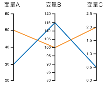
平行坐标图可以显示多变量的数值数据,最适合用来同一时间比较许多变量,并表示它们之间的关系。缺点也很明显,
不同的轴线排列顺序可能会影响读者对数据的理解。
快速绘制
-
基于pandas
import pandas
import matplotlib.pyplot as plt
import seaborn as sns
from pandas.plotting import parallel_coordinates

# 导入数据
data = sns.load_dataset('iris')

# 利用parallel_coordinates快速绘制
parallel_coordinates(data, 'species', colormap=plt.get_cmap("Set2"))
plt.show()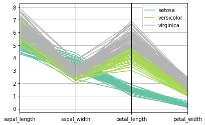
-
基于plotly
import plotly.express as px

# 导入数据
df = px.data.iris()

# 利用parallel_coordinates快速绘制
fig = px.parallel_coordinates(
    df,
    color="species_id",
    labels={"species_id": "Species","sepal_width": "Sepal Width", "sepal_length": "Sepal Length", "petal_width": "Petal Width", "petal_length": "Petal Length", },
    color_continuous_scale=px.colors.diverging.Tealrose,
    color_continuous_midpoint=2)

# 隐藏色阶bar
fig.update_layout(coloraxis_showscale=False)

fig.show()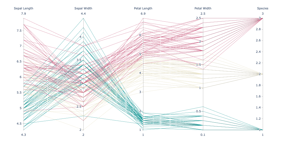
绘制类平行坐标图
-
利用searbon绘制(点线图)
import matplotlib.pyplot as plt
import seaborn as sns
import pandas as pd

# 导入数据
url = "https://raw.githubusercontent.com/jennybc/gapminder/master/data-raw/08_gap-every-five-years.tsv"
df = pd.read_csv(url, sep='\t')

# 计算各变量均值
average_data = df.groupby('continent')[['gdpPercap', 'lifeExp', 'pop']].mean()

# 各变量标准化处理
normalized_data = (average_data - average_data.mean()) / average_data.std()

# 绘制平行坐标图
plt.figure(figsize=(8, 6))
parallel_plot = sns.lineplot(data=normalized_data.transpose(),
                             dashes=False,
                             markers=True,
                             markersize=8)

# 标题
plt.title('Parallel Plot \nAverage GDP, Life Expectancy, and Population by Continent')

# 删除y轴刻度与标签
plt.yticks([])

# 图例
plt.legend(title='Continent',
           bbox_to_anchor=(1, 1),
          )

plt.show()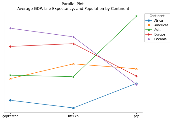
-
利用matplotlib绘制(斜率图)
import matplotlib.pyplot as plt
import pandas as pd

# 导入数据
url = "https://raw.githubusercontent.com/jennybc/gapminder/master/data-raw/08_gap-every-five-years.tsv"
df = pd.read_csv(url, sep='\t')

def add_label(continent_name, year):
    '''
    添加文本标签
    '''
    # 计算y位置
    y_position = round(df[year][continent_name])

    # 计算x位置
    if year==1952:
        x_position = year - 1.2
    else:
        x_position = year + 0.12

    # 添加标签
    plt.text(x_position,
             y_position,
             f'{continent_name}, {y_position}',
             fontsize=8,
             color='black',
            )


# 筛选1952~1957的数据
years = [1952, 1957]
df = df[df['year'].isin(years)]

# 计算每个大陆每年的平均 GDP
df = df.groupby(['continent', 'year'])['gdpPercap'].mean().unstack()

# 人为改变一个值,使至少一个大陆在两个日期之间减少(方便对比下降数据)
df.loc['Oceania',1957] = 8503

# 初始化布局
plt.figure(figsize=(6, 8))

# 年份的y轴(1952、1957)
plt.axvline(x=years[0], color='black', linestyle='--', linewidth=1) # 1952
plt.axvline(x=years[1], color='black', linestyle='--', linewidth=1) # 1957

# 添加y标签(BEFORE、AFTER)
plt.text(1951, 11000, 'BEFORE', fontsize=12, color='black', fontweight='bold')
plt.text(1957.1, 11000, 'AFTER', fontsize=12, color='black', fontweight='bold')

# 绘制每个大陆的线
for continent in df.index:

    # 计算1952、1957的gdp
    value_before = df[df.index==continent][years[0]][0]
    value_after = df[df.index==continent][years[1]][0]

    # 上升为绿色、下降为红色
    if value_before > value_after:
        color='red'
    else:
        color='green'

    # 添加线
    plt.plot(years, df.loc[continent], marker='o', label=continent, color=color)

# 每年添加各大洲的标签
for continent_name in df.index:
    for year in df.columns:
        add_label(continent_name, year)

# 标题
plt.title(f'Slope Chart: \nComparing GDP Per Capita between {years[0]} vs {years[1]}  \n\n\n')

# 删除y轴
plt.yticks([])

# 删除边框
plt.box(False)

plt.show()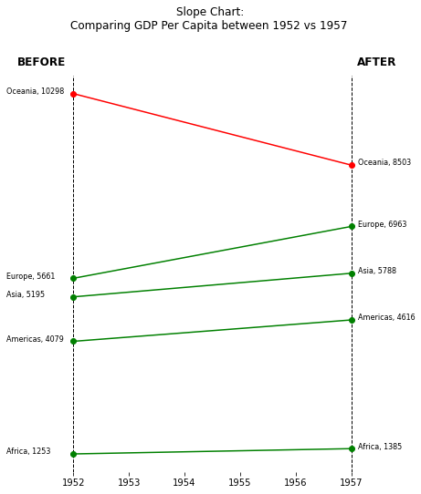
总结
以上通过pandas的parallel_coordinates和plotly的parallel_coordinates快速绘制平行坐标图,并利用seaborn和matplotlib绘制类平行坐标图。
共勉~











![[C++深入] --- malloc/free和new/delete](https://img-blog.csdnimg.cn/direct/41e1a2ecc9be486d85ac0515f7ee226d.png)


