文章目录
- 综述
- Symbol的分类
- Point的符号化
- Point符号化为二维几何:
- Point位图符号化:
- Point的三维结合符号化
- Point 符号化为GLTF模型
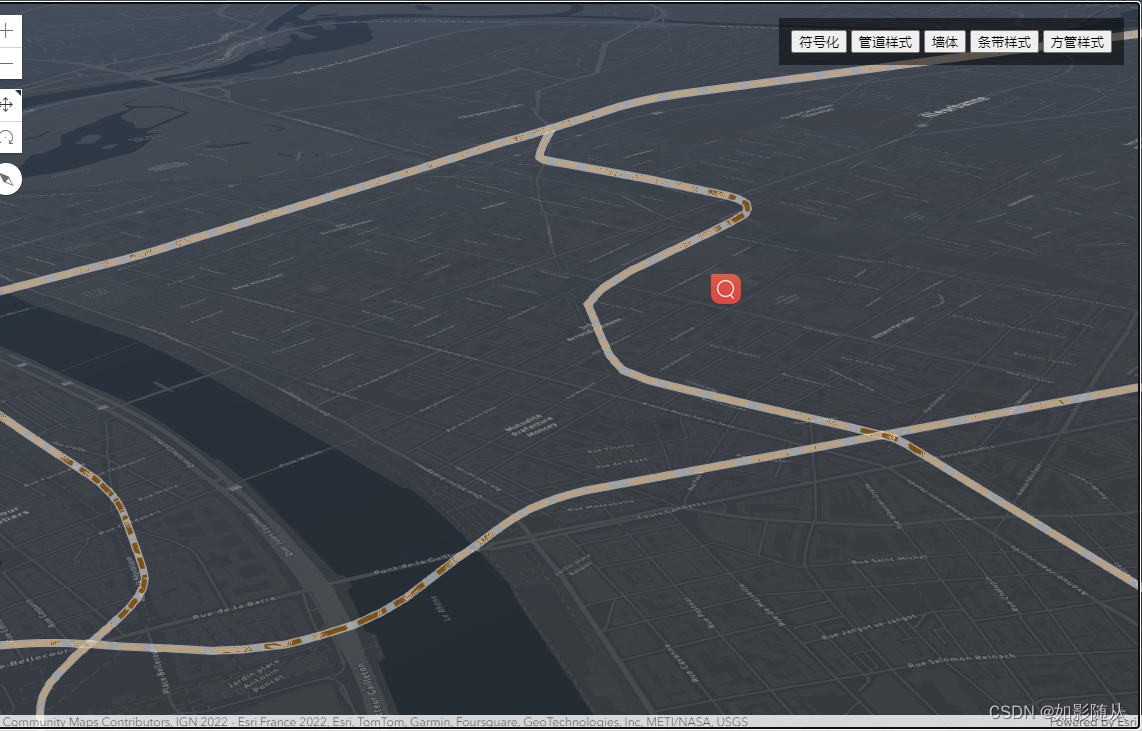
- PolylineSymbol-线符号化
- 基本样式
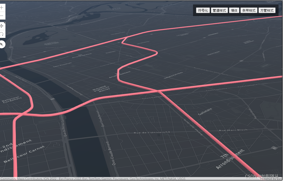
- 管道样式
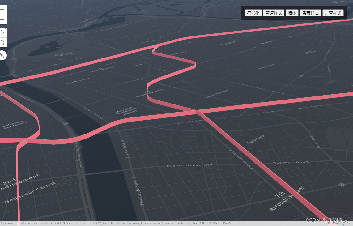
- 墙体样式
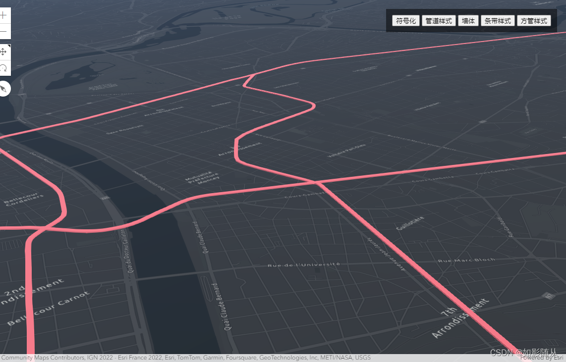
- 条带样式
- 方管样式
- PolygonSymbol-面符号化
- 水面效果
- 拉伸效果
- 填充效果
- MeshSymbol
- 结语
综述
ArcGIS中的符号化,及将矢量数据(点、线、面)通过给其设置颜色、边框、样式实例化为一个具化的对象。
ArcGIS提供了Symbol去处理符号化问题。Symbol定义如何在GraphicLayer上如何显示点、线、面、文本,符号定义了几何对象所有的非地理特征方面的外观,例如图形的颜色,边框线样式,api中有许多的符号类,每个类都只允许你使用唯一的方式去制定符号。每种符号都用于一种特定的类型。

Symbol的分类
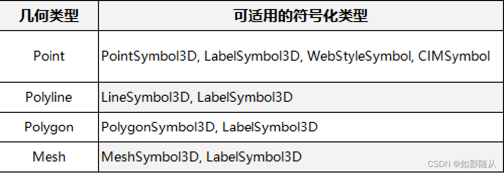
在ArcGIS中有多种Symbol符号化类,大致可分为四类:
- PointSymbol
- PolylineSymbol
- PolygonSymbol
- MeshSymbol
Point的符号化
对于点数据,我们一般可以做一下几种符号化处理:
- 符号化为二维的几何
- 符号化为位图
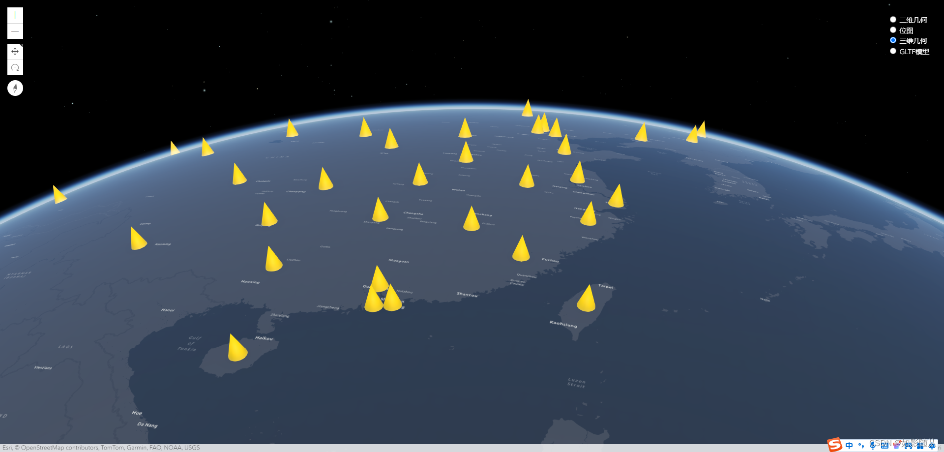
- 符号化为三维几何
- 符号化为GLTF模型
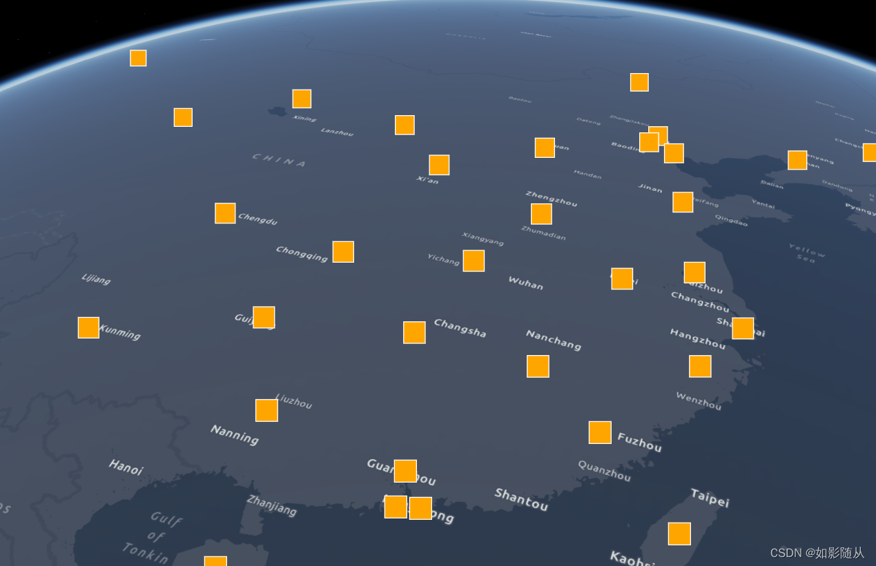
Point符号化为二维几何:
const iconSymbolForGeometry = {
            type: "point-3d", // autocasts as new PointSymbol3D()
            symbolLayers: [
              {
                type: "icon", // autocasts as new IconSymbol3DLayer()
                size: 24,
                resource: {
                  primitive: "square"
                },
                material: {
                  color: "orange"
                },
                outline: {
                  color: "white",
                  size: 1
                }
              }
            ]
          };
结果:
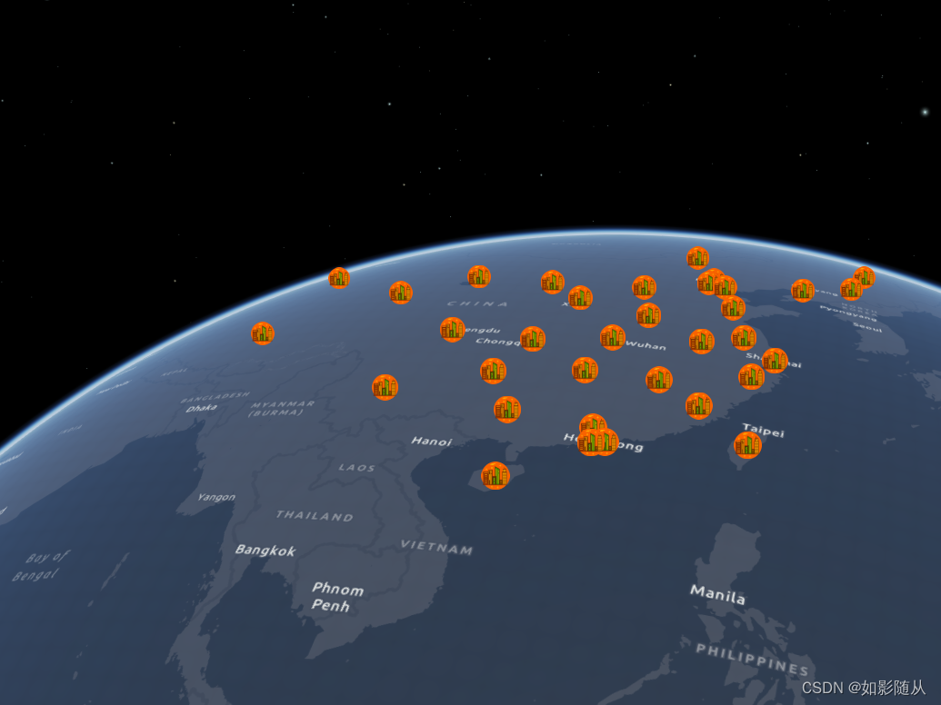
Point位图符号化:
const iconSymbolForImage = {
            type: "point-3d", // autocasts as new PointSymbol3D()
            symbolLayers: [
              {
                type: "icon", // autocasts as new IconSymbol3DLayer()
                size: 24,
                resource: {
                href: './img/city.png'
                },
                material: {
                  color: "orange"
                },
                outline: {
                  color: "white",
                  size: 1
                }
              }
            ]
          };
结果:
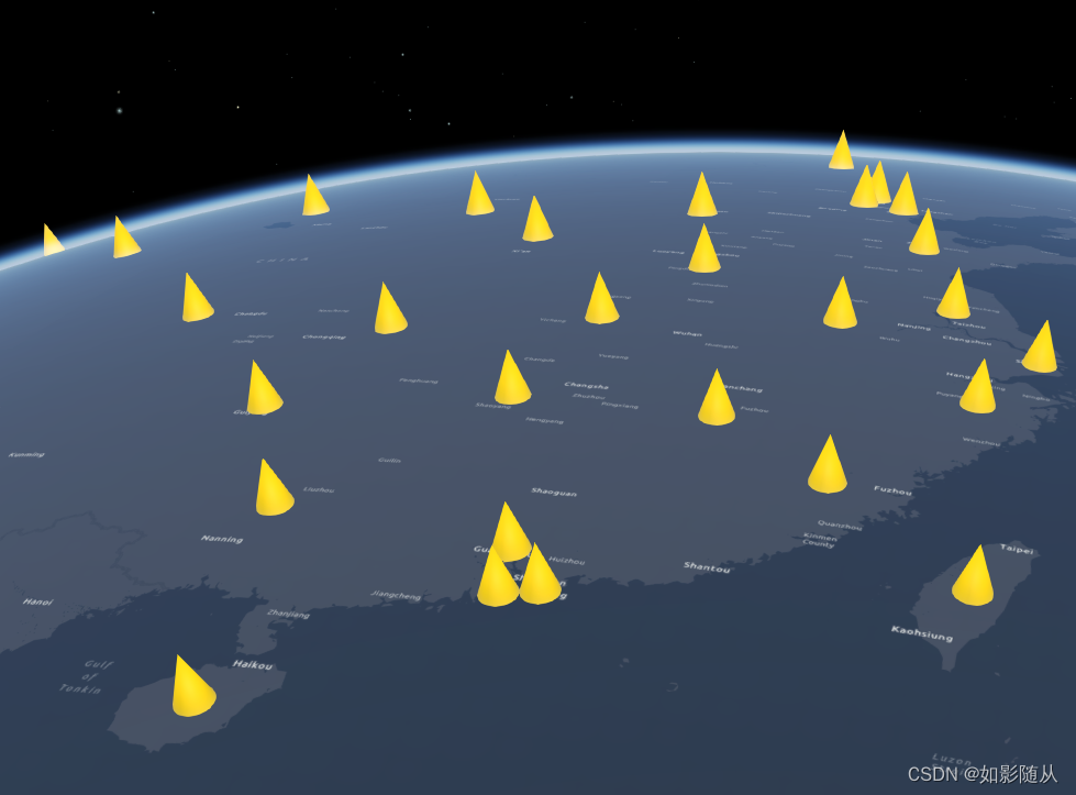
Point的三维结合符号化
const objectSymbolForGeometry = {
            type: "point-3d", // autocasts as new PointSymbol3D()
            symbolLayers: [
              {
                type: "object", // autocasts as new ObjectSymbol3DLayer()
                width: 70000,
                height: 100000,
                resource: {
                  primitive: "cone" //三维圆锥
                },
                material: {
                  color: "#FFD700"
                }
              }
            ]
          };
结果:
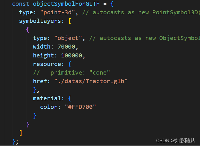
Point 符号化为GLTF模型
const objectSymbolForGLTF = {
            type: "point-3d", // autocasts as new PointSymbol3D()
            symbolLayers: [
              {
                type: "object", // autocasts as new ObjectSymbol3DLayer()
                width: 70000,
                height: 100000,
                resource: {
                //   primitive: "cone"
                href: "./datas/Tractor.glb"
                },
                material: {
                  color: "#FFD700"
                }
              }
            ]
          };
结果:
然后将符号化设置赋值给featurelayer对象就能实现符号化的操作:
const objectSymbolRenderer = {
            type: "simple", // autocasts as new SimpleRenderer()
            symbol: objectSymbolForGeometry
          };
featureLayer.renderer = objectSymbolRenderer;
完成代码如下:
<html lang="en">
    <head>
      <meta charset="utf-8" />
      <meta name="viewport" content="initial-scale=1, maximum-scale=1,user-scalable=no"/>
      <title>Point3DSymbol</title>
      <style>
        html,
        body,
        #viewDiv {
          padding: 0;
          margin: 0;
          height: 100%;
          width: 100%;
        }

        #paneDiv {
          position: absolute;
          top: 18px;
          right: 18px;
          padding: 12px;
          background-color: rgba(0, 0, 0, 0.5);
          color: white;
        }
      </style>

      <link rel="stylesheet" href="https://js.arcgis.com/4.27/esri/themes/light/main.css"/>
      <script src="https://js.arcgis.com/4.27/"></script>
      <script>
        require([
          "esri/Map",
          "esri/views/SceneView",
          "esri/layers/FeatureLayer",
          "esri/layers/support/LabelClass",
          "esri/layers/GeoJSONLayer"
        ], (Map, SceneView, FeatureLayer, LabelClass, GeoJSONLayer) => {
          const map = new Map({
            basemap: "dark-gray-vector"
          });

          const view = new SceneView({
            container: "viewDiv",
            map: map,
            camera: {
              position: [109.5996,35.6396, 9326260]
            }
          });

          // Create iconSymbol and add to renderer
          const iconSymbolForGeometry = {
            type: "point-3d", // autocasts as new PointSymbol3D()
            symbolLayers: [
              {
                type: "icon", // autocasts as new IconSymbol3DLayer()
                size: 24,
                resource: {
                  primitive: "square"
                },
                material: {
                  color: "orange"
                },
                outline: {
                  color: "white",
                  size: 1
                }
              }
            ]
          };

          const iconSymbolForImage = {
            type: "point-3d", // autocasts as new PointSymbol3D()
            symbolLayers: [
              {
                type: "icon", // autocasts as new IconSymbol3DLayer()
                size: 24,
                resource: {
                href: './img/city.png'
                },
                material: {
                  color: "orange"
                },
                outline: {
                  color: "white",
                  size: 1
                }
              }
            ]
          };

          const iconSymbolRenderer = {
            type: "simple", // autocasts as new SimpleRenderer()
            symbol: iconSymbolForGeometry
          };

          const iconSymbolForImageRender = {
            type: "simple", // autocasts as new SimpleRenderer()
            symbol: iconSymbolForImage
          }

          // Create objectSymbol and add to renderer
          const objectSymbolForGeometry = {
            type: "point-3d", // autocasts as new PointSymbol3D()
            symbolLayers: [
              {
                type: "object", // autocasts as new ObjectSymbol3DLayer()
                width: 70000,
                height: 100000,
                resource: {
                  primitive: "cone" //三维圆锥
                },
                material: {
                  color: "#FFD700"
                }
              }
            ]
          };

          const objectSymbolForGLTF = {
            type: "point-3d", // autocasts as new PointSymbol3D()
            symbolLayers: [
              {
                type: "object", // autocasts as new ObjectSymbol3DLayer()
                width: 70000,
                height: 100000,
                resource: {
                //   primitive: "cone"
                href: "./datas/Tractor.glb"
                },
                material: {
                  color: "#FFD700"
                }
              }
            ]
          };

          const objectSymbolRenderer = {
            type: "simple", // autocasts as new SimpleRenderer()
            symbol: objectSymbolForGeometry
          };

          const objectSymbolForGLTFRenderer = {
            type: "simple", // autocasts as new SimpleRenderer()
            symbol: objectSymbolForGLTF
          };

          const labelClass = new LabelClass({
            symbol: {
              type: "label-3d", // autocasts as new LabelSymbol3D()
              symbolLayers: [
                {
                  type: "text", // autocasts as new TextSymbol3DLayer()
                  material: {
                    color: "white"
                  },
                  size: 10
                }
              ]
            },
            labelPlacement: "above-center",
            labelExpressionInfo: {
            //   expression: 'DefaultValue($feature.CITY_NAME, "no data")'
            expression: 'DefaultValue($feature.NAME, "no data")'
            }
          });

        const featureLayer = new GeoJSONLayer({
            url: "./datas/china.json",
            renderer: iconSymbolRenderer,
            outFields: ["NAME"],
            // Ensure that all features are shown at all scales
            maxScale: 0,
            minScale: 0,
            // labelingInfo: [labelClass]
          });
          map.add(featureLayer);

          // Register the events listener to toggle between objectSymbol and iconSymbol
          const asIconForGeometry = document.getElementById("asIconForGeometry");
          const asIconForImage = document.getElementById("asIconForImage");
          const asObjectForGeometry = document.getElementById("asObjectForGeometry");
          const asObjectForGLTF = document.getElementById("asObjectForGLTF");

          asIconForGeometry.addEventListener("click", () => {
            featureLayer.renderer = iconSymbolRenderer;
          });
          asIconForImage.addEventListener("click", () => {
            featureLayer.renderer = iconSymbolForImageRender;
          });
          asObjectForGeometry.addEventListener("click", () => {
            featureLayer.renderer = objectSymbolRenderer;
          });
          asObjectForGLTF.addEventListener("click", () => {
            featureLayer.renderer = objectSymbolForGLTFRenderer;
          });


        });
      </script>
    </head>

    <body>
      <div id="viewDiv"></div>
      <div id="paneDiv" class="esri-widget">
        <div>
          <input type="radio" name="symbolType" value="icon" checked="checked" id="asIconForGeometry"/>
          <label for="asIconForGeometry">二维几何 </label>
        </div>
        <div>
            <input type="radio" name="symbolType" value="icon"  id="asIconForImage"/>
            <label for="asIconForImage">位图 </label>
          </div>
        <div>
          <input type="radio" name="symbolType" value="object" id="asObjectForGeometry" />
          <label for="asObjectForGeometry">三维几何</label>
        </div>
        <div>
            <input type="radio" name="symbolType" value="icon"  id="asObjectForGLTF"/>
            <label for="asObjectForGLTF">GLTF模型</label>
          </div>
      </div>
    </body>
  </html>
china.json数据如下:
{"type": "FeatureCollection",
"features":
[
{"type": "Feature","properties":{"id":"65","name":"新疆","cp":[84.9023,41.748],"childNum":18},"geometry":{"type":"Polygon","coordinates":[[[96.416,42.7588],[96.416,42.7148],[95.9766,42.4951],[96.0645,42.3193],[96.2402,42.2314],[95.9766,41.9238],[95.2734,41.6162],[95.1855,41.792],[94.5703,41.4844],[94.043,41.0889],[93.8672,40.6934],[93.0762,40.6494],[92.6367,39.6387],[92.373,39.3311],[92.373,39.1113],[92.373,39.0234],[90.1758,38.4961],[90.3516,38.2324],[90.6152,38.3203],[90.5273,37.8369],[91.0547,37.4414],[91.3184,37.0898],[90.7031,36.7822],[90.791,36.6064],[91.0547,36.5186],[91.0547,36.0791],[90.8789,36.0352],[90,36.2549],[89.9121,36.0791],[89.7363,36.0791],[89.209,36.2988],[88.7695,36.3428],[88.5938,36.4746],[87.3633,36.4307],[86.2207,36.167],[86.1328,35.8594],[85.6055,35.6836],[85.0781,35.7275],[84.1992,35.376],[83.1445,35.4199],[82.8809,35.6836],[82.4414,35.7275],[82.002,35.332],[81.6504,35.2441],[80.4199,35.4199],[80.2441,35.2881],[80.332,35.1563],[80.2441,35.2002],[79.8926,34.8047],[79.8047,34.4971],[79.1016,34.4531],[79.0137,34.3213],[78.2227,34.7168],[78.0469,35.2441],[78.0469,35.5078],[77.4316,35.4639],[76.8164,35.6396],[76.5527,35.8594],[76.2012,35.8154],[75.9375,36.0352],[76.0254,36.4746],[75.8496,36.6943],[75.498,36.7383],[75.4102,36.958],[75.0586,37.002],[74.8828,36.9141],[74.7949,37.0459],[74.5313,37.0898],[74.5313,37.2217],[74.8828,37.2217],[75.1465,37.4414],[74.8828,37.5732],[74.9707,37.749],[74.8828,38.4521],[74.3555,38.6719],[74.1797,38.6719],[74.0918,38.54],[73.8281,38.584],[73.7402,38.8477],[73.8281,38.9795],[73.4766,39.375],[73.916,39.5068],[73.916,39.6826],[73.8281,39.7705],[74.0039,40.0342],[74.8828,40.3418],[74.7949,40.5176],[75.2344,40.4297],[75.5859,40.6494],[75.7617,40.2979],[76.377,40.3857],[76.9043,41.001],[77.6074,41.001],[78.1348,41.2207],[78.1348,41.3965],[80.1563,42.0557],[80.2441,42.2754],[80.1563,42.627],[80.2441,42.8467],[80.5078,42.8906],[80.4199,43.0664],[80.7715,43.1982],[80.4199,44.165],[80.4199,44.6045],[79.9805,44.8242],[79.9805,44.9561],[81.7383,45.3955],[82.0898,45.2197],[82.5293,45.2197],[82.2656,45.6592],[83.0566,47.2412],[83.6719,47.0215],[84.7266,47.0215],[84.9023,46.8896],[85.5176,47.0654],[85.6934,47.2852],[85.5176,48.1201],[85.7813,48.4277],[86.5723,48.5596],[86.8359,48.8232],[86.748,48.9551],[86.8359,49.1309],[87.8027,49.1748],[87.8906,48.999],[87.7148,48.9111],[88.0664,48.7354],[87.9785,48.6035],[88.5059,48.3838],[88.6816,48.1641],[89.1211,47.9883],[89.5605,48.0322],[89.7363,47.8564],[90.0879,47.8564],[90.3516,47.6807],[90.5273,47.2412],[90.8789,46.9775],[91.0547,46.582],[90.8789,46.3184],[91.0547,46.0107],[90.7031,45.7471],[90.7031,45.5273],[90.8789,45.2197],[91.582,45.0879],[93.5156,44.9561],[94.7461,44.3408],[95.3613,44.2969],[95.3613,44.0332],[95.5371,43.9014],[95.8887,43.2422],[96.3281,42.9346],[96.416,42.7588]]]}},
{"type": "Feature","properties":{"id":"54","name":"西藏","cp":[88.7695,31.6846],"childNum":7},"geometry":{"type":"Polygon","coordinates":[[[79.0137,34.3213],[79.1016,34.4531],[79.8047,34.4971],[79.8926,34.8047],[80.2441,35.2002],[80.332,35.1563],[80.2441,35.2881],[80.4199,35.4199],[81.6504,35.2441],[82.002,35.332],[82.4414,35.7275],[82.8809,35.6836],[83.1445,35.4199],[84.1992,35.376],[85.0781,35.7275],[85.6055,35.6836],[86.1328,35.8594],[86.2207,36.167],[87.3633,36.4307],[88.5938,36.4746],[88.7695,36.3428],[89.209,36.2988],[89.7363,36.0791],[89.3848,36.0352],[89.4727,35.9033],[89.7363,35.7715],[89.7363,35.4199],[89.4727,35.376],[89.4727,35.2441],[89.5605,34.8926],[89.8242,34.8486],[89.7363,34.6729],[89.8242,34.3652],[89.6484,34.0137],[90.0879,33.4863],[90.7031,33.1348],[91.4063,33.1348],[91.9336,32.8271],[92.1973,32.8271],[92.2852,32.7393],[92.9883,32.7393],[93.5156,32.4756],[93.7793,32.5635],[94.1309,32.4316],[94.6582,32.6074],[95.1855,32.4316],[95.0098,32.2998],[95.1855,32.3438],[95.2734,32.2119],[95.3613,32.168],[95.3613,31.9922],[95.4492,31.8164],[95.8008,31.6846],[95.9766,31.8164],[96.1523,31.5967],[96.2402,31.9482],[96.5039,31.7285],[96.8555,31.6846],[96.7676,31.9922],[97.2949,32.0801],[97.3828,32.5635],[97.7344,32.5195],[98.1738,32.3438],[98.4375,31.8604],[98.877,31.4209],[98.6133,31.2012],[98.9648,30.7617],[99.1406,29.2676],[98.9648,29.1357],[98.9648,28.8281],[98.7891,28.8721],[98.7891,29.0039],[98.7012,28.916],[98.6133,28.5205],[98.7891,28.3447],[98.7012,28.2129],[98.3496,28.125],[98.2617,28.3887],[98.1738,28.125],[97.5586,28.5205],[97.2949,28.0811],[97.3828,27.9053],[97.0313,27.7295],[96.5039,28.125],[95.7129,28.2568],[95.3613,28.125],[95.2734,27.9492],[94.2188,27.5537],[93.8672,27.0264],[93.6035,26.9385],[92.1094,26.8506],[92.0215,27.4658],[91.582,27.5537],[91.582,27.9053],[91.4063,28.0371],[91.0547,27.8613],[90.7031,28.0811],[89.8242,28.2129],[89.6484,28.1689],[89.1211,27.5977],[89.1211,27.334],[89.0332,27.2021],[88.7695,27.4219],[88.8574,27.9932],[88.6816,28.125],[88.1543,27.9053],[87.8906,27.9492],[87.7148,27.8174],[87.0996,27.8174],[86.748,28.125],[86.5723,28.125],[86.4844,27.9053],[86.1328,28.125],[86.0449,27.9053],[85.6934,28.3447],[85.6055,28.2568],[85.166,28.3447],[85.166,28.6523],[84.9023,28.5645],[84.4629,28.7402],[84.2871,28.8721],[84.1992,29.2236],[84.1113,29.2676],[83.584,29.1797],[83.2324,29.5752],[82.1777,30.0586],[82.0898,30.3223],[81.3867,30.3662],[81.2109,30.0146],[81.0352,30.2344],[80.0684,30.5859],[79.7168,30.9375],[79.0137,31.0693],[78.75,31.333],[78.8379,31.5967],[78.6621,31.8164],[78.75,31.9043],[78.4863,32.124],[78.3984,32.5195],[78.75,32.6953],[78.9258,32.3438],[79.2773,32.5635],[79.1016,33.1787],[78.6621,33.6621],[78.6621,34.1016],[78.9258,34.1455],[79.0137,34.3213]]]}},
{"type": "Feature","properties":{"id":"15","name":"内蒙古","cp":[117.5977,44.3408],"childNum":12},"geometry":{"type":"Polygon","coordinates":[[[97.207,42.8027],[99.4922,42.583],[100.8105,42.6709],[101.7773,42.4951],[102.041,42.2314],[102.7441,42.1436],[103.3594,41.8799],[103.8867,41.792],[104.502,41.8799],[104.502,41.6602],[105.0293,41.5723],[105.7324,41.9238],[107.4023,42.4512],[109.4238,42.4512],[110.3906,42.7588],[111.0059,43.3301],[111.9727,43.6816],[111.9727,43.8135],[111.4453,44.3848],[111.7969,45],[111.9727,45.0879],[113.6426,44.7363],[114.1699,44.9561],[114.5215,45.3955],[115.6641,45.4395],[116.1914,45.7031],[116.2793,45.9668],[116.543,46.2744],[117.334,46.3623],[117.4219,46.582],[117.7734,46.5381],[118.3008,46.7578],[118.7402,46.7139],[118.916,46.7578],[119.0918,46.6699],[119.707,46.626],[119.9707,46.7139],[119.707,47.1973],[118.4766,47.9883],[117.8613,48.0322],[117.334,47.6807],[116.8066,47.9004],[116.1914,47.8564],[115.9277,47.6807],[115.5762,47.9004],[115.4883,48.1641],[115.8398,48.252],[115.8398,48.5596],[116.7188,49.834],[117.7734,49.5264],[118.5645,49.9219],[119.2676,50.0977],[119.3555,50.3174],[119.1797,50.3613],[119.5313,50.7568],[119.5313,50.8887],[119.707,51.0645],[120.1465,51.6797],[120.6738,51.9434],[120.7617,52.1191],[120.7617,52.251],[120.5859,52.3389],[120.6738,52.5146],[120.4102,52.6465],[120.0586,52.6025],[120.0586,52.7344],[120.8496,53.2617],[121.4648,53.3496],[121.8164,53.042],[121.2012,52.5586],[121.6406,52.4268],[121.7285,52.2949],[121.9922,52.2949],[122.168,52.5146],[122.6953,52.251],[122.6074,52.0752],[122.959,51.3281],[123.3105,51.2402],[123.6621,51.3721],[124.3652,51.2842],[124.541,51.3721],[124.8926,51.3721],[125.0684,51.6357],[125.332,51.6357],[126.0352,51.0205],[125.7715,50.7568],[125.7715,50.5371],[125.332,50.1416],[125.1563,49.834],[125.2441,49.1748],[124.8047,49.1309],[124.4531,48.1201],[124.2773,48.5156],[122.4316,47.373],[123.0469,46.7139],[123.3984,46.8896],[123.3984,46.9775],[123.4863,46.9775],[123.5742,46.8457],[123.5742,46.8896],[123.5742,46.6699],[123.0469,46.582],[123.2227,46.2305],[122.7832,46.0107],[122.6953,45.7031],[122.4316,45.8789],[122.2559,45.791],[121.8164,46.0107],[121.7285,45.7471],[121.9043,45.7031],[122.2559,45.2637],[122.0801,44.8682],[122.3438,44.2529],[123.1348,44.4727],[123.4863,43.7256],[123.3105,43.5059],[123.6621,43.374],[123.5742,43.0225],[123.3105,42.9785],[123.1348,42.8027],[122.7832,42.7148],[122.3438,42.8467],[122.3438,42.6709],[121.9922,42.7148],[121.7285,42.4512],[121.4648,42.4951],[120.498,42.0996],[120.1465,41.7041],[119.8828,42.1875],[119.5313,42.3633],[119.3555,42.2754],[119.2676,41.7041],[119.4434,41.6162],[119.2676,41.3086],[118.3887,41.3086],[118.125,41.748],[118.3008,41.792],[118.3008,42.0996],[118.125,42.0557],[117.9492,42.2314],[118.0371,42.4072],[117.7734,42.627],[117.5098,42.583],[117.334,42.4512],[116.8945,42.4072],[116.8066,42.0117],[116.2793,42.0117],[116.0156,41.792],[115.9277,41.9238],[115.2246,41.5723],[114.9609,41.6162],[114.873,42.0996],[114.5215,42.1436],[114.1699,41.792],[114.2578,41.5723],[113.9063,41.4404],[113.9941,41.2207],[113.9063,41.1328],[114.082,40.7373],[114.082,40.5176],[113.8184,40.5176],[113.5547,40.3418],[113.2031,40.3857],[112.7637,40.166],[112.3242,40.2539],[111.9727,39.5947],[111.4453,39.6387],[111.3574,39.4189],[111.0938,39.375],[111.0938,39.5947],[110.6543,39.2871],[110.127,39.4629],[110.2148,39.2871],[109.8633,39.2432],[109.9512,39.1553],[108.9844,38.3203],[109.0723,38.0127],[108.8965,37.9688],[108.8086,38.0127],[108.7207,37.7051],[108.1934,37.6172],[107.666,37.8809],[107.3145,38.1006],[106.7871,38.1885],[106.5234,38.3203],[106.9629,38.9795],[106.7871,39.375],[106.3477,39.2871],[105.9082,38.7158],[105.8203,37.793],[104.3262,37.4414],[103.4473,37.8369],[103.3594,38.0127],[103.5352,38.1445],[103.4473,38.3643],[104.2383,38.9795],[104.0625,39.4189],[103.3594,39.3311],[103.0078,39.1113],[102.4805,39.2432],[101.8652,39.1113],[102.041,38.8916],[101.7773,38.6719],[101.3379,38.7598],[101.25,39.0234],[100.9863,38.9355],[100.8105,39.4189],[100.5469,39.4189],[100.0195,39.7705],[99.4922,39.8584],[100.1074,40.2539],[100.1953,40.6494],[99.9316,41.001],[99.2285,40.8691],[99.0527,40.6934],[98.9648,40.7813],[98.7891,40.6055],[98.5254,40.7373],[98.6133,40.6494],[98.3496,40.5615],[98.3496,40.9131],[97.4707,41.4844],[97.8223,41.6162],[97.8223,41.748],[97.207,42.8027]]]}},
{"type": "Feature","properties":{"id":"63","name":"青海","cp":[96.2402,35.4199],"childNum":8},"geometry":{"type":"Polygon","coordinates":[[[89.7363,36.0791],[89.9121,36.0791],[90,36.2549],[90.8789,36.0352],[91.0547,36.0791],[91.0547,36.5186],[90.791,36.6064],[90.7031,36.7822],[91.3184,37.0898],[91.0547,37.4414],[90.5273,37.8369],[90.6152,38.3203],[90.3516,38.2324],[90.1758,38.4961],[92.373,39.0234],[92.373,39.1113],[93.1641,39.1992],[93.1641,38.9795],[93.6914,38.9355],[93.8672,38.7158],[94.3066,38.7598],[94.5703,38.3643],[95.0098,38.4082],[95.4492,38.2764],[95.7129,38.3643],[96.2402,38.1006],[96.416,38.2324],[96.6797,38.1885],[96.6797,38.4521],[97.1191,38.584],[97.0313,39.1992],[98.1738,38.8037],[98.3496,39.0234],[98.6133,38.9355],[98.7891,39.0674],[99.1406,38.9355],[99.8438,38.3643],[100.1953,38.2764],[100.0195,38.4521],[100.1074,38.4961],[100.459,38.2764],[100.7227,38.2324],[101.1621,37.8369],[101.5137,37.8809],[101.7773,37.6172],[101.9531,37.7051],[102.1289,37.4414],[102.5684,37.1777],[102.4805,36.958],[102.6563,36.8262],[102.5684,36.7383],[102.832,36.3428],[103.0078,36.2549],[102.9199,36.0791],[102.9199,35.9033],[102.6563,35.7715],[102.832,35.5957],[102.4805,35.5957],[102.3047,35.4199],[102.3926,35.2002],[101.9531,34.8486],[101.9531,34.6289],[102.2168,34.4092],[102.1289,34.2773],[101.6895,34.1016],[100.9863,34.3652],[100.8105,34.2773],[101.25,33.6621],[101.5137,33.7061],[101.6016,33.5303],[101.7773,33.5303],[101.6895,33.3105],[101.7773,33.2227],[101.6016,33.1348],[101.1621,33.2227],[101.25,32.6953],[100.7227,32.6514],[100.7227,32.5195],[100.3711,32.7393],[100.1074,32.6514],[100.1074,32.8711],[99.8438,33.0029],[99.7559,32.7393],[99.2285,32.915],[99.2285,33.0469],[98.877,33.1787],[98.4375,34.0576],[97.8223,34.1895],[97.6465,34.1016],[97.7344,33.9258],[97.3828,33.8818],[97.4707,33.5742],[97.7344,33.3984],[97.3828,32.8711],[97.4707,32.6953],[97.7344,32.5195],[97.3828,32.5635],[97.2949,32.0801],[96.7676,31.9922],[96.8555,31.6846],[96.5039,31.7285],[96.2402,31.9482],[96.1523,31.5967],[95.9766,31.8164],[95.8008,31.6846],[95.4492,31.8164],[95.3613,31.9922],[95.3613,32.168],[95.2734,32.2119],[95.1855,32.3438],[95.0098,32.2998],[95.1855,32.4316],[94.6582,32.6074],[94.1309,32.4316],[93.7793,32.5635],[93.5156,32.4756],[92.9883,32.7393],[92.2852,32.7393],[92.1973,32.8271],[91.9336,32.8271],[91.4063,33.1348],[90.7031,33.1348],[90.0879,33.4863],[89.6484,34.0137],[89.8242,34.3652],[89.7363,34.6729],[89.8242,34.8486],[89.5605,34.8926],[89.4727,35.2441],[89.4727,35.376],[89.7363,35.4199],[89.7363,35.7715],[89.4727,35.9033],[89.3848,36.0352],[89.7363,36.0791]]]}},
{"type": "Feature","properties":{"id":"51","name":"四川","cp":[102.9199,30.1904],"childNum":21},"geometry":{"type":"Polygon","coordinates":[[[101.7773,33.5303],[101.8652,33.5742],[101.9531,33.4424],[101.8652,33.0908],[102.4805,33.4424],[102.2168,33.9258],[102.9199,34.3213],[103.0957,34.1895],[103.1836,33.7939],[104.1504,33.6182],[104.2383,33.3984],[104.4141,33.3105],[104.3262,33.2227],[104.4141,33.0469],[104.3262,32.8711],[104.4141,32.7393],[105.2051,32.6074],[105.3809,32.7393],[105.3809,32.8711],[105.4688,32.915],[105.5566,32.7393],[106.084,32.8711],[106.084,32.7393],[106.3477,32.6514],[107.0508,32.6953],[107.1387,32.4756],[107.2266,32.4316],[107.4023,32.5195],[108.0176,32.168],[108.2813,32.2559],[108.5449,32.2119],[108.3691,32.168],[108.2813,31.9043],[108.5449,31.6846],[108.1934,31.5088],[107.9297,30.8496],[107.4902,30.8496],[107.4023,30.7617],[107.4902,30.6299],[107.0508,30.0146],[106.7871,30.0146],[106.6113,30.3223],[106.2598,30.1904],[105.8203,30.4541],[105.6445,30.2783],[105.5566,30.1025],[105.7324,29.8828],[105.293,29.5313],[105.4688,29.3115],[105.7324,29.2676],[105.8203,28.96],[106.2598,28.8721],[106.3477,28.5205],[105.9961,28.7402],[105.6445,28.4326],[105.9082,28.125],[106.1719,28.125],[106.3477,27.8174],[105.6445,27.6416],[105.5566,27.7734],[105.293,27.7295],[105.2051,27.9932],[105.0293,28.0811],[104.8535,27.9053],[104.4141,27.9492],[104.3262,28.0371],[104.4141,28.125],[104.4141,28.2568],[104.2383,28.4326],[104.4141,28.6084],[103.8867,28.6523],[103.7988,28.3008],[103.4473,28.125],[103.4473,27.7734],[102.9199,27.29],[103.0078,26.3672],[102.6563,26.1914],[102.5684,26.3672],[102.1289,26.1035],[101.8652,26.0596],[101.6016,26.2354],[101.6895,26.3672],[101.4258,26.5869],[101.4258,26.8066],[101.4258,26.7188],[101.1621,27.0264],[101.1621,27.1582],[100.7227,27.8613],[100.3711,27.8174],[100.2832,27.7295],[100.0195,28.125],[100.1953,28.3447],[99.668,28.8281],[99.4043,28.5205],[99.4043,28.1689],[99.2285,28.3008],[99.1406,29.2676],[98.9648,30.7617],[98.6133,31.2012],[98.877,31.4209],[98.4375,31.8604],[98.1738,32.3438],[97.7344,32.5195],[97.4707,32.6953],[97.3828,32.8711],[97.7344,33.3984],[97.4707,33.5742],[97.3828,33.8818],[97.7344,33.9258],[97.6465,34.1016],[97.8223,34.1895],[98.4375,34.0576],[98.877,33.1787],[99.2285,33.0469],[99.2285,32.915],[99.7559,32.7393],[99.8438,33.0029],[100.1074,32.8711],[100.1074,32.6514],[100.3711,32.7393],[100.7227,32.5195],[100.7227,32.6514],[101.25,32.6953],[101.1621,33.2227],[101.6016,33.1348],[101.7773,33.2227],[101.6895,33.3105],[101.7773,33.5303]]]}},
{"type": "Feature","properties":{"id":"23","name":"黑龙江","cp":[128.1445,48.5156],"childNum":13},"geometry":{"type":"Polygon","coordinates":[[[121.4648,53.3496],[123.6621,53.5693],[124.8926,53.0859],[125.0684,53.2178],[125.5957,53.0859],[125.6836,52.9102],[126.123,52.7783],[126.0352,52.6025],[126.2109,52.5146],[126.3867,52.2949],[126.3867,52.207],[126.5625,52.1631],[126.4746,51.9434],[126.9141,51.3721],[126.8262,51.2842],[127.002,51.3281],[126.9141,51.1084],[127.2656,50.7568],[127.3535,50.2734],[127.6172,50.2295],[127.5293,49.8779],[127.793,49.6143],[128.7598,49.5703],[129.1113,49.3506],[129.4629,49.4385],[130.2539,48.8672],[130.6934,48.8672],[130.5176,48.6475],[130.8691,48.2959],[130.6934,48.1201],[131.0449,47.6807],[132.5391,47.7246],[132.627,47.9443],[133.0664,48.1201],[133.5059,48.1201],[134.209,48.3838],[135.0879,48.4277],[134.7363,48.252],[134.5605,47.9883],[134.7363,47.6807],[134.5605,47.4609],[134.3848,47.4609],[134.209,47.2852],[134.209,47.1533],[133.8574,46.5381],[133.9453,46.2744],[133.5059,45.835],[133.418,45.5713],[133.2422,45.5273],[133.0664,45.1318],[132.8906,45.0439],[131.9238,45.3516],[131.5723,45.0439],[131.0449,44.8682],[131.3086,44.0771],[131.2207,43.7256],[131.3086,43.4619],[130.8691,43.418],[130.5176,43.6377],[130.3418,43.9893],[129.9902,43.8574],[129.9023,44.0332],[129.8145,43.9014],[129.2871,43.8135],[129.1992,43.5938],[128.8477,43.5498],[128.4961,44.165],[128.4082,44.4727],[128.0566,44.3408],[128.0566,44.1211],[127.7051,44.1211],[127.5293,44.6045],[127.0898,44.6045],[127.002,44.7803],[127.0898,45],[126.9141,45.1318],[126.5625,45.2637],[126.0352,45.1758],[125.7715,45.3076],[125.6836,45.5273],[125.0684,45.3955],[124.8926,45.5273],[124.3652,45.4395],[124.0137,45.7471],[123.9258,46.2305],[123.2227,46.2305],[123.0469,46.582],[123.5742,46.6699],[123.5742,46.8896],[123.5742,46.8457],[123.4863,46.9775],[123.3984,46.9775],[123.3984,46.8896],[123.0469,46.7139],[122.4316,47.373],[124.2773,48.5156],[124.4531,48.1201],[124.8047,49.1309],[125.2441,49.1748],[125.1563,49.834],[125.332,50.1416],[125.7715,50.5371],[125.7715,50.7568],[126.0352,51.0205],[125.332,51.6357],[125.0684,51.6357],[124.8926,51.3721],[124.541,51.3721],[124.3652,51.2842],[123.6621,51.3721],[123.3105,51.2402],[122.959,51.3281],[122.6074,52.0752],[122.6953,52.251],[122.168,52.5146],[121.9922,52.2949],[121.7285,52.2949],[121.6406,52.4268],[121.2012,52.5586],[121.8164,53.042],[121.4648,53.3496]]]}},
{"type": "Feature","properties":{"id":"62","name":"甘肃","cp":[95.7129,40.166],"childNum":14},"geometry":{"type":"Polygon","coordinates":[[[96.416,42.7148],[97.207,42.8027],[97.8223,41.748],[97.8223,41.6162],[97.4707,41.4844],[98.3496,40.9131],[98.3496,40.5615],[98.6133,40.6494],[98.5254,40.7373],[98.7891,40.6055],[98.9648,40.7813],[99.0527,40.6934],[99.2285,40.8691],[99.9316,41.001],[100.1953,40.6494],[100.1074,40.2539],[99.4922,39.8584],[100.0195,39.7705],[100.5469,39.4189],[100.8105,39.4189],[100.9863,38.9355],[101.25,39.0234],[101.3379,38.7598],[101.7773,38.6719],[102.041,38.8916],[101.8652,39.1113],[102.4805,39.2432],[103.0078,39.1113],[103.3594,39.3311],[104.0625,39.4189],[104.2383,38.9795],[103.4473,38.3643],[103.5352,38.1445],[103.3594,38.0127],[103.4473,37.8369],[104.3262,37.4414],[104.5898,37.4414],[104.5898,37.2217],[104.8535,37.2217],[105.293,36.8262],[105.2051,36.6943],[105.4688,36.123],[105.293,35.9912],[105.3809,35.7715],[105.7324,35.7275],[105.8203,35.5518],[105.9961,35.4639],[105.9082,35.4199],[105.9961,35.4199],[106.084,35.376],[106.2598,35.4199],[106.3477,35.2441],[106.5234,35.332],[106.4355,35.6836],[106.6992,35.6836],[106.9629,35.8154],[106.875,36.123],[106.5234,36.2549],[106.5234,36.4746],[106.4355,36.5625],[106.6113,36.7822],[106.6113,37.0898],[107.3145,37.0898],[107.3145,36.9141],[108.7207,36.3428],[108.6328,35.9912],[108.5449,35.8594],[108.6328,35.5518],[108.5449,35.2881],[107.7539,35.2881],[107.7539,35.1123],[107.8418,35.0244],[107.666,34.9365],[107.2266,34.8926],[106.9629,35.0684],[106.6113,35.0684],[106.5234,34.7607],[106.3477,34.585],[106.6992,34.3213],[106.5234,34.2773],[106.6113,34.1455],[106.4355,33.9258],[106.5234,33.5303],[105.9961,33.6182],[105.7324,33.3984],[105.9961,33.1787],[105.9082,33.0029],[105.4688,32.915],[105.3809,32.8711],[105.3809,32.7393],[105.2051,32.6074],[104.4141,32.7393],[104.3262,32.8711],[104.4141,33.0469],[104.3262,33.2227],[104.4141,33.3105],[104.2383,33.3984],[104.1504,33.6182],[103.1836,33.7939],[103.0957,34.1895],[102.9199,34.3213],[102.2168,33.9258],[102.4805,33.4424],[101.8652,33.0908],[101.9531,33.4424],[101.8652,33.5742],[101.7773,33.5303],[101.6016,33.5303],[101.5137,33.7061],[101.25,33.6621],[100.8105,34.2773],[100.9863,34.3652],[101.6895,34.1016],[102.1289,34.2773],[102.2168,34.4092],[101.9531,34.6289],[101.9531,34.8486],[102.3926,35.2002],[102.3047,35.4199],[102.4805,35.5957],[102.832,35.5957],[102.6563,35.7715],[102.9199,35.9033],[102.9199,36.0791],[103.0078,36.2549],[102.832,36.3428],[102.5684,36.7383],[102.6563,36.8262],[102.4805,36.958],[102.5684,37.1777],[102.1289,37.4414],[101.9531,37.7051],[101.7773,37.6172],[101.5137,37.8809],[101.1621,37.8369],[100.7227,38.2324],[100.459,38.2764],[100.1074,38.4961],[100.0195,38.4521],[100.1953,38.2764],[99.8438,38.3643],[99.1406,38.9355],[98.7891,39.0674],[98.6133,38.9355],[98.3496,39.0234],[98.1738,38.8037],[97.0313,39.1992],[97.1191,38.584],[96.6797,38.4521],[96.6797,38.1885],[96.416,38.2324],[96.2402,38.1006],[95.7129,38.3643],[95.4492,38.2764],[95.0098,38.4082],[94.5703,38.3643],[94.3066,38.7598],[93.8672,38.7158],[93.6914,38.9355],[93.1641,38.9795],[93.1641,39.1992],[92.373,39.1113],[92.373,39.3311],[92.6367,39.6387],[93.0762,40.6494],[93.8672,40.6934],[94.043,41.0889],[94.5703,41.4844],[95.1855,41.792],[95.2734,41.6162],[95.9766,41.9238],[96.2402,42.2314],[96.0645,42.3193],[95.9766,42.4951],[96.416,42.7148]]]}},
{"type": "Feature","properties":{"id":"53","name":"云南","cp":[101.8652,25.1807],"childNum":16},"geometry":{"type":"Polygon","coordinates":[[[98.1738,28.125],[98.2617,28.3887],[98.3496,28.125],[98.7012,28.2129],[98.7891,28.3447],[98.6133,28.5205],[98.7012,28.916],[98.7891,29.0039],[98.7891,28.8721],[98.9648,28.8281],[98.9648,29.1357],[99.1406,29.2676],[99.2285,28.3008],[99.4043,28.1689],[99.4043,28.5205],[99.668,28.8281],[100.1953,28.3447],[100.0195,28.125],[100.2832,27.7295],[100.3711,27.8174],[100.7227,27.8613],[101.1621,27.1582],[101.1621,27.0264],[101.4258,26.7188],[101.4258,26.8066],[101.4258,26.5869],[101.6895,26.3672],[101.6016,26.2354],[101.8652,26.0596],[102.1289,26.1035],[102.5684,26.3672],[102.6563,26.1914],[103.0078,26.3672],[102.9199,27.29],[103.4473,27.7734],[103.4473,28.125],[103.7988,28.3008],[103.8867,28.6523],[104.4141,28.6084],[104.2383,28.4326],[104.4141,28.2568],[104.4141,28.125],[104.3262,28.0371],[104.4141,27.9492],[104.8535,27.9053],[105.0293,28.0811],[105.2051,27.9932],[105.293,27.7295],[105.2051,27.3779],[104.5898,27.334],[104.4141,27.4658],[104.1504,27.2461],[103.8867,27.4219],[103.623,27.0264],[103.7109,26.9824],[103.7109,26.7627],[103.8867,26.543],[104.4141,26.6748],[104.6777,26.4111],[104.3262,25.708],[104.8535,25.2246],[104.5898,25.0488],[104.6777,24.9609],[104.502,24.7412],[104.6777,24.3457],[104.7656,24.4775],[105.0293,24.4336],[105.2051,24.082],[105.4688,24.0381],[105.5566,24.126],[105.9961,24.126],[106.1719,23.8184],[106.1719,23.5547],[105.6445,23.4229],[105.5566,23.2031],[105.293,23.3789],[104.8535,23.1592],[104.7656,22.8516],[104.3262,22.6758],[104.1504,22.8076],[103.9746,22.5439],[103.623,22.7637],[103.5352,22.5879],[103.3594,22.8076],[103.0957,22.4561],[102.4805,22.7637],[102.3047,22.4121],[101.8652,22.3682],[101.7773,22.5],[101.6016,22.1924],[101.8652,21.6211],[101.7773,21.1377],[101.6016,21.2256],[101.25,21.1816],[101.1621,21.7529],[100.6348,21.4453],[100.1074,21.4893],[99.9316,22.0605],[99.2285,22.1484],[99.4043,22.5879],[99.3164,22.7197],[99.4922,23.0713],[98.877,23.2031],[98.7012,23.9502],[98.877,24.126],[98.1738,24.082],[97.7344,23.8623],[97.5586,23.9063],[97.7344,24.126],[97.6465,24.4336],[97.5586,24.4336],[97.5586,24.7412],[97.7344,24.8291],[97.8223,25.2686],[98.1738,25.4004],[98.1738,25.6201],[98.3496,25.5762],[98.5254,25.8398],[98.7012,25.8838],[98.6133,26.0596],[98.7012,26.1475],[98.7891,26.5869],[98.7012,27.5098],[98.5254,27.6416],[98.3496,27.5098],[98.1738,28.125]]]}},
{"type": "Feature","properties":{"id":"45","name":"广西","cp":[108.2813,23.6426],"childNum":14},"geometry":{"type":"Polygon","coordinates":[[[104.502,24.7412],[104.6777,24.6094],[105.2051,24.9609],[105.9961,24.6533],[106.1719,24.7852],[106.1719,24.9609],[106.875,25.1807],[107.0508,25.2686],[106.9629,25.4883],[107.2266,25.6201],[107.4902,25.2246],[107.7539,25.2246],[107.8418,25.1367],[108.1055,25.2246],[108.1934,25.4443],[108.3691,25.5322],[108.6328,25.3125],[108.6328,25.5762],[109.0723,25.5322],[108.9844,25.752],[109.3359,25.708],[109.5117,26.0156],[109.7754,25.8838],[109.9512,26.1914],[110.2148,25.9717],[110.5664,26.3232],[111.1816,26.3232],[111.2695,26.2354],[111.2695,25.8838],[111.4453,25.8398],[111.0059,25.0049],[111.0938,24.9609],[111.3574,25.1367],[111.5332,24.6533],[111.709,24.7852],[112.0605,24.7412],[111.8848,24.6533],[112.0605,24.3457],[111.8848,24.2139],[111.8848,23.9941],[111.7969,23.8184],[111.6211,23.8184],[111.6211,23.6865],[111.3574,23.4668],[111.4453,23.0273],[111.2695,22.8076],[110.7422,22.5439],[110.7422,22.2803],[110.6543,22.1484],[110.3027,22.1484],[110.3027,21.8848],[109.9512,21.8408],[109.8633,21.665],[109.7754,21.6211],[109.7754,21.4014],[109.5996,21.4453],[109.1602,21.3574],[109.248,20.874],[109.0723,20.9619],[109.0723,21.5332],[108.7207,21.5332],[108.6328,21.665],[108.2813,21.4893],[107.8418,21.6211],[107.4023,21.6211],[107.0508,21.7969],[107.0508,21.9287],[106.6992,22.0166],[106.6113,22.4121],[106.7871,22.7637],[106.6992,22.8955],[105.9082,22.9395],[105.5566,23.0713],[105.5566,23.2031],[105.6445,23.4229],[106.1719,23.5547],[106.1719,23.8184],[105.9961,24.126],[105.5566,24.126],[105.4688,24.0381],[105.2051,24.082],[105.0293,24.4336],[104.7656,24.4775],[104.6777,24.3457],[104.502,24.7412]]]}},
{"type": "Feature","properties":{"id":"43","name":"湖南","cp":[111.5332,27.3779],"childNum":14},"geometry":{"type":"Polygon","coordinates":[[[109.248,28.4766],[109.248,29.1357],[109.5117,29.6191],[109.6875,29.6191],[109.7754,29.751],[110.4785,29.6631],[110.6543,29.751],[110.4785,30.0146],[110.8301,30.1465],[111.7969,29.9268],[112.2363,29.5313],[112.5,29.6191],[112.6758,29.5752],[112.9395,29.7949],[113.0273,29.751],[112.9395,29.4873],[113.0273,29.4434],[113.5547,29.8389],[113.5547,29.707],[113.7305,29.5752],[113.6426,29.3115],[113.7305,29.0918],[113.9063,29.0479],[114.1699,28.8281],[114.082,28.5645],[114.2578,28.3447],[113.7305,27.9492],[113.6426,27.5977],[113.6426,27.3779],[113.8184,27.29],[113.7305,27.1143],[113.9063,26.9385],[113.9063,26.6309],[114.082,26.5869],[113.9941,26.1914],[114.2578,26.1475],[113.9941,26.0596],[113.9063,25.4443],[113.6426,25.3125],[113.2031,25.5322],[112.8516,25.3564],[113.0273,25.2246],[113.0273,24.9609],[112.8516,24.917],[112.5879,25.1367],[112.2363,25.1807],[112.1484,24.873],[112.0605,24.7412],[111.709,24.7852],[111.5332,24.6533],[111.3574,25.1367],[111.0938,24.9609],[111.0059,25.0049],[111.4453,25.8398],[111.2695,25.8838],[111.2695,26.2354],[111.1816,26.3232],[110.5664,26.3232],[110.2148,25.9717],[109.9512,26.1914],[109.7754,25.8838],[109.5117,26.0156],[109.4238,26.2793],[109.248,26.3232],[109.4238,26.5869],[109.3359,26.7188],[109.5117,26.8066],[109.5117,27.0264],[109.3359,27.1582],[108.8965,27.0264],[108.8086,27.1143],[109.4238,27.5977],[109.3359,27.9053],[109.3359,28.2568],[109.248,28.4766]]]}},
{"type": "Feature","properties":{"id":"61","name":"陕西","cp":[109.5996,35.6396],"childNum":10},"geometry":{"type":"Polygon","coordinates":[[[105.4688,32.915],[105.9082,33.0029],[105.9961,33.1787],[105.7324,33.3984],[105.9961,33.6182],[106.5234,33.5303],[106.4355,33.9258],[106.6113,34.1455],[106.5234,34.2773],[106.6992,34.3213],[106.3477,34.585],[106.5234,34.7607],[106.6113,35.0684],[106.9629,35.0684],[107.2266,34.8926],[107.666,34.9365],[107.8418,35.0244],[107.7539,35.1123],[107.7539,35.2881],[108.5449,35.2881],[108.6328,35.5518],[108.5449,35.8594],[108.6328,35.9912],[108.7207,36.3428],[107.3145,36.9141],[107.3145,37.0898],[107.3145,37.6172],[107.666,37.8809],[108.1934,37.6172],[108.7207,37.7051],[108.8086,38.0127],[108.8965,37.9688],[109.0723,38.0127],[108.9844,38.3203],[109.9512,39.1553],[109.8633,39.2432],[110.2148,39.2871],[110.127,39.4629],[110.6543,39.2871],[111.0938,39.5947],[111.0938,39.375],[111.1816,39.2432],[110.918,38.7158],[110.8301,38.4961],[110.4785,38.1885],[110.4785,37.9688],[110.8301,37.6611],[110.3906,37.002],[110.4785,36.123],[110.5664,35.6396],[110.2148,34.8926],[110.2148,34.6729],[110.3906,34.585],[110.4785,34.2334],[110.6543,34.1455],[110.6543,33.8379],[111.0059,33.5303],[111.0059,33.2666],[110.7422,33.1348],[110.5664,33.2666],[110.3027,33.1787],[109.5996,33.2666],[109.4238,33.1348],[109.7754,33.0469],[109.7754,32.915],[110.127,32.7393],[110.127,32.6074],[109.6875,32.6074],[109.5117,32.4316],[109.5996,31.7285],[109.248,31.7285],[109.0723,31.9482],[108.5449,32.2119],[108.2813,32.2559],[108.0176,32.168],[107.4023,32.5195],[107.2266,32.4316],[107.1387,32.4756],[107.0508,32.6953],[106.3477,32.6514],[106.084,32.7393],[106.084,32.8711],[105.5566,32.7393],[105.4688,32.915]]]}},
{"type": "Feature","properties":{"id":"44","name":"广东","cp":[113.4668,22.8076],"childNum":21},"geometry":{"type":"Polygon","coordinates":[[[109.7754,21.4014],[109.7754,21.6211],[109.8633,21.665],[109.9512,21.8408],[110.3027,21.8848],[110.3027,22.1484],[110.6543,22.1484],[110.7422,22.2803],[110.7422,22.5439],[111.2695,22.8076],[111.4453,23.0273],[111.3574,23.4668],[111.6211,23.6865],[111.6211,23.8184],[111.7969,23.8184],[111.8848,23.9941],[111.8848,24.2139],[112.0605,24.3457],[111.8848,24.6533],[112.0605,24.7412],[112.1484,24.873],[112.2363,25.1807],[112.5879,25.1367],[112.8516,24.917],[113.0273,24.9609],[113.0273,25.2246],[112.8516,25.3564],[113.2031,25.5322],[113.6426,25.3125],[113.9063,25.4443],[113.9941,25.2686],[114.6094,25.4004],[114.7852,25.2686],[114.6973,25.1367],[114.4336,24.9609],[114.1699,24.6973],[114.4336,24.5215],[115.4004,24.7852],[115.8398,24.5654],[115.752,24.7852],[115.9277,24.917],[116.2793,24.7852],[116.3672,24.873],[116.543,24.6094],[116.7188,24.6533],[116.9824,24.1699],[116.9824,23.9063],[117.1582,23.5547],[117.334,23.2471],[116.8945,23.3789],[116.6309,23.1152],[116.543,22.8516],[115.9277,22.7197],[115.6641,22.7637],[115.5762,22.6318],[115.0488,22.6758],[114.6094,22.3682],[114.3457,22.5439],[113.9941,22.5],[113.8184,22.1924],[114.3457,22.1484],[114.4336,22.0166],[114.082,21.9287],[113.9941,21.7969],[113.5547,22.0166],[113.1152,21.8408],[112.9395,21.5771],[112.4121,21.4453],[112.2363,21.5332],[111.5332,21.4893],[111.2695,21.3574],[110.7422,21.3574],[110.6543,21.2256],[110.7422,20.918],[110.4785,20.874],[110.6543,20.2588],[110.5664,20.2588],[110.3906,20.127],[110.0391,20.127],[109.8633,20.127],[109.8633,20.3027],[109.5996,20.918],[109.7754,21.4014],[109.7754,21.4014]],[[113.5986,22.1649],[113.6096,22.1265],[113.5547,22.11],[113.5437,22.2034],[113.5767,22.2034],[113.5986,22.1649]]]}},
{"type": "Feature","properties":{"id":"22","name":"吉林","cp":[126.4746,43.5938],"childNum":9},"geometry":{"type":"Polygon","coordinates":[[[123.2227,46.2305],[123.9258,46.2305],[124.0137,45.7471],[124.3652,45.4395],[124.8926,45.5273],[125.0684,45.3955],[125.6836,45.5273],[125.7715,45.3076],[126.0352,45.1758],[126.5625,45.2637],[126.9141,45.1318],[127.0898,45],[127.002,44.7803],[127.0898,44.6045],[127.5293,44.6045],[127.7051,44.1211],[128.0566,44.1211],[128.0566,44.3408],[128.4082,44.4727],[128.4961,44.165],[128.8477,43.5498],[129.1992,43.5938],[129.2871,43.8135],[129.8145,43.9014],[129.9023,44.0332],[129.9902,43.8574],[130.3418,43.9893],[130.5176,43.6377],[130.8691,43.418],[131.3086,43.4619],[131.3086,43.3301],[131.1328,42.9346],[130.4297,42.7148],[130.6055,42.6709],[130.6055,42.4512],[130.2539,42.7588],[130.2539,42.8906],[130.166,42.9785],[129.9023,43.0225],[129.7266,42.4951],[129.375,42.4512],[128.9355,42.0117],[128.0566,42.0117],[128.3203,41.5723],[128.1445,41.3525],[127.0898,41.5283],[127.1777,41.5723],[126.9141,41.792],[126.6504,41.6602],[126.4746,41.3965],[126.123,40.957],[125.6836,40.8691],[125.5957,40.9131],[125.7715,41.2207],[125.332,41.6602],[125.332,41.9678],[125.4199,42.0996],[125.332,42.1436],[124.8926,42.8027],[124.8926,43.0664],[124.7168,43.0664],[124.4531,42.8467],[124.2773,43.2422],[123.8379,43.4619],[123.6621,43.374],[123.3105,43.5059],[123.4863,43.7256],[123.1348,44.4727],[122.3438,44.2529],[122.0801,44.8682],[122.2559,45.2637],[121.9043,45.7031],[121.7285,45.7471],[121.8164,46.0107],[122.2559,45.791],[122.4316,45.8789],[122.6953,45.7031],[122.7832,46.0107],[123.2227,46.2305]]]}},
{"type": "Feature","properties":{"id":"13","name":"河北","cp":[115.4004,37.9688],"childNum":11},"geometry":{"type":"MultiPolygon","coordinates":[[[[114.5215,39.5068],[114.3457,39.8584],[113.9941,39.9902],[114.5215,40.3418],[114.3457,40.3857],[114.2578,40.6055],[114.082,40.7373],[113.9063,41.1328],[113.9941,41.2207],[113.9063,41.4404],[114.2578,41.5723],[114.1699,41.792],[114.5215,42.1436],[114.873,42.0996],[114.9609,41.6162],[115.2246,41.5723],[115.9277,41.9238],[116.0156,41.792],[116.2793,42.0117],[116.8066,42.0117],[116.8945,42.4072],[117.334,42.4512],[117.5098,42.583],[117.7734,42.627],[118.0371,42.4072],[117.9492,42.2314],[118.125,42.0557],[118.3008,42.0996],[118.3008,41.792],[118.125,41.748],[118.3887,41.3086],[119.2676,41.3086],[118.8281,40.8252],[119.2676,40.5176],[119.5313,40.5615],[119.707,40.1221],[119.8828,39.9463],[119.5313,39.6826],[119.4434,39.4189],[118.916,39.0674],[118.4766,38.9355],[118.125,39.0234],[118.0371,39.1992],[118.0371,39.2432],[117.8613,39.4189],[117.9492,39.5947],[117.6855,39.5947],[117.5098,39.7705],[117.5098,39.9902],[117.6855,39.9902],[117.6855,40.0781],[117.4219,40.21],[117.2461,40.5176],[117.4219,40.6494],[116.9824,40.6934],[116.6309,41.0449],[116.3672,40.9131],[116.4551,40.7813],[116.1914,40.7813],[116.1035,40.6055],[115.752,40.5615],[115.9277,40.2539],[115.4004,39.9463],[115.4883,39.6387],[115.752,39.5068],[116.1914,39.5947],[116.3672,39.4629],[116.543,39.5947],[116.8066,39.5947],[116.8945,39.1113],[116.7188,38.9355],[116.7188,38.8037],[117.2461,38.54],[117.5977,38.6279],[117.9492,38.3203],[117.4219,37.8369],[116.8066,37.8369],[116.4551,37.4854],[116.2793,37.5732],[116.2793,37.3535],[116.0156,37.3535],[115.752,36.9141],[115.3125,36.5186],[115.4883,36.167],[115.3125,36.0791],[115.1367,36.2109],[114.9609,36.0791],[114.873,36.123],[113.7305,36.3428],[113.4668,36.6504],[113.7305,36.8701],[113.7305,37.1338],[114.1699,37.6611],[113.9941,37.7051],[113.8184,38.1445],[113.5547,38.2764],[113.5547,38.54],[113.8184,38.8037],[113.8184,38.9355],[113.9063,39.0234],[114.3457,39.0674],[114.5215,39.5068]]],[[[117.2461,40.0781],[117.1582,39.8145],[117.1582,39.6387],[116.8945,39.6826],[116.8945,39.8145],[116.8066,39.9902],[117.2461,40.0781]]]]}},
{"type": "Feature","properties":{"id":"42","name":"湖北","cp":[112.2363,31.1572],"childNum":17},"geometry":{"type":"Polygon","coordinates":[[[110.2148,31.1572],[110.127,31.377],[109.6875,31.5527],[109.7754,31.6846],[109.5996,31.7285],[109.5117,32.4316],[109.6875,32.6074],[110.127,32.6074],[110.127,32.7393],[109.7754,32.915],[109.7754,33.0469],[109.4238,33.1348],[109.5996,33.2666],[110.3027,33.1787],[110.5664,33.2666],[110.7422,33.1348],[111.0059,33.2666],[111.5332,32.6074],[112.3242,32.3438],[113.2031,32.4316],[113.4668,32.2998],[113.7305,32.4316],[113.8184,31.8604],[113.9941,31.7725],[114.1699,31.8604],[114.5215,31.7725],[114.6094,31.5527],[114.7852,31.4648],[115.1367,31.5967],[115.2246,31.4209],[115.4004,31.4209],[115.5762,31.2012],[116.0156,31.0254],[115.752,30.6738],[116.1035,30.1904],[116.1035,29.8389],[115.9277,29.707],[115.4883,29.7949],[114.873,29.3994],[114.2578,29.3555],[113.9063,29.0479],[113.7305,29.0918],[113.6426,29.3115],[113.7305,29.5752],[113.5547,29.707],[113.5547,29.8389],[113.0273,29.4434],[112.9395,29.4873],[113.0273,29.751],[112.9395,29.7949],[112.6758,29.5752],[112.5,29.6191],[112.2363,29.5313],[111.7969,29.9268],[110.8301,30.1465],[110.4785,30.0146],[110.6543,29.751],[110.4785,29.6631],[109.7754,29.751],[109.6875,29.6191],[109.5117,29.6191],[109.248,29.1357],[109.0723,29.3555],[108.9844,29.3115],[108.6328,29.8389],[108.457,29.7949],[108.5449,30.2344],[108.457,30.4102],[108.6328,30.5859],[108.8086,30.498],[109.0723,30.6299],[109.1602,30.542],[109.248,30.6299],[109.4238,30.542],[109.8633,30.8936],[110.0391,30.8057],[110.2148,31.1572]]]}},
{"type": "Feature","properties":{"id":"52","name":"贵州","cp":[106.6113,26.9385],"childNum":9},"geometry":{"type":"Polygon","coordinates":[[[104.1504,27.2461],[104.4141,27.4658],[104.5898,27.334],[105.2051,27.3779],[105.293,27.7295],[105.5566,27.7734],[105.6445,27.6416],[106.3477,27.8174],[106.1719,28.125],[105.9082,28.125],[105.6445,28.4326],[105.9961,28.7402],[106.3477,28.5205],[106.5234,28.5645],[106.4355,28.7842],[106.5234,28.7842],[106.6113,28.6523],[106.6113,28.5205],[106.6992,28.4766],[106.875,28.7842],[107.4023,28.8721],[107.4023,29.1797],[107.5781,29.2236],[107.8418,29.1357],[107.8418,29.0039],[108.2813,29.0918],[108.3691,28.6523],[108.5449,28.6523],[108.5449,28.3887],[108.7207,28.4766],[108.7207,28.2129],[109.0723,28.2129],[109.248,28.4766],[109.3359,28.2568],[109.3359,27.9053],[109.4238,27.5977],[108.8086,27.1143],[108.8965,27.0264],[109.3359,27.1582],[109.5117,27.0264],[109.5117,26.8066],[109.3359,26.7188],[109.4238,26.5869],[109.248,26.3232],[109.4238,26.2793],[109.5117,26.0156],[109.3359,25.708],[108.9844,25.752],[109.0723,25.5322],[108.6328,25.5762],[108.6328,25.3125],[108.3691,25.5322],[108.1934,25.4443],[108.1055,25.2246],[107.8418,25.1367],[107.7539,25.2246],[107.4902,25.2246],[107.2266,25.6201],[106.9629,25.4883],[107.0508,25.2686],[106.875,25.1807],[106.1719,24.9609],[106.1719,24.7852],[105.9961,24.6533],[105.2051,24.9609],[104.6777,24.6094],[104.502,24.7412],[104.6777,24.9609],[104.5898,25.0488],[104.8535,25.2246],[104.3262,25.708],[104.6777,26.4111],[104.4141,26.6748],[103.8867,26.543],[103.7109,26.7627],[103.7109,26.9824],[103.623,27.0264],[103.8867,27.4219],[104.1504,27.2461]]]}},
{"type": "Feature","properties":{"id":"37","name":"山东","cp":[118.7402,36.4307],"childNum":17},"geometry":{"type":"Polygon","coordinates":[[[115.4883,36.167],[115.3125,36.5186],[115.752,36.9141],[116.0156,37.3535],[116.2793,37.3535],[116.2793,37.5732],[116.4551,37.4854],[116.8066,37.8369],[117.4219,37.8369],[117.9492,38.3203],[118.125,38.1445],[118.916,38.1445],[119.3555,37.6611],[119.0039,37.5293],[119.0039,37.3535],[119.3555,37.1338],[119.707,37.1338],[119.8828,37.3975],[120.498,37.8369],[120.5859,38.1445],[120.9375,38.4521],[121.0254,37.8369],[121.2012,37.6611],[121.9043,37.4854],[122.168,37.6172],[122.2559,37.4854],[122.6074,37.4854],[122.6953,37.3535],[122.6074,36.9141],[122.4316,36.7822],[121.8164,36.8701],[121.7285,36.6943],[121.1133,36.6064],[121.1133,36.4307],[121.377,36.2549],[120.7617,36.167],[120.9375,35.8594],[120.6738,36.0352],[119.707,35.4639],[119.9707,34.9805],[119.3555,35.0244],[119.2676,35.1123],[118.916,35.0244],[118.7402,34.7168],[118.4766,34.6729],[118.3887,34.4092],[118.2129,34.4092],[118.125,34.6289],[117.9492,34.6729],[117.5977,34.4531],[117.334,34.585],[117.2461,34.4531],[116.8066,34.9365],[116.4551,34.8926],[116.3672,34.6289],[116.1914,34.585],[115.5762,34.585],[115.4004,34.8486],[114.7852,35.0684],[115.0488,35.376],[115.2246,35.4199],[115.4883,35.7275],[116.1035,36.0791],[115.3125,35.8154],[115.4883,36.167]]]}},
{"type": "Feature","properties":{"id":"36","name":"江西","cp":[116.0156,27.29],"childNum":11},"geometry":{"type":"Polygon","coordinates":[[[114.2578,28.3447],[114.082,28.5645],[114.1699,28.8281],[113.9063,29.0479],[114.2578,29.3555],[114.873,29.3994],[115.4883,29.7949],[115.9277,29.707],[116.1035,29.8389],[116.2793,29.7949],[116.7188,30.0586],[116.8945,29.9268],[116.7188,29.751],[116.7188,29.6191],[117.1582,29.707],[117.0703,29.8389],[117.1582,29.9268],[117.5098,29.6191],[118.0371,29.5752],[118.2129,29.3994],[118.0371,29.1797],[118.0371,29.0479],[118.3887,28.7842],[118.4766,28.3447],[118.4766,28.3008],[118.3008,28.0811],[117.7734,27.8174],[117.5098,27.9932],[116.9824,27.6416],[117.1582,27.29],[117.0703,27.1143],[116.543,26.8066],[116.6309,26.4551],[116.3672,26.2354],[116.4551,26.1035],[116.1914,25.8838],[116.0156,25.2686],[115.8398,25.2246],[115.9277,24.917],[115.752,24.7852],[115.8398,24.5654],[115.4004,24.7852],[114.4336,24.5215],[114.1699,24.6973],[114.4336,24.9609],[114.6973,25.1367],[114.7852,25.2686],[114.6094,25.4004],[113.9941,25.2686],[113.9063,25.4443],[113.9941,26.0596],[114.2578,26.1475],[113.9941,26.1914],[114.082,26.5869],[113.9063,26.6309],[113.9063,26.9385],[113.7305,27.1143],[113.8184,27.29],[113.6426,27.3779],[113.6426,27.5977],[113.7305,27.9492],[114.2578,28.3447]]]}},
{"type": "Feature","properties":{"id":"41","name":"河南","cp":[113.4668,33.8818],"childNum":17},"geometry":{"type":"Polygon","coordinates":[[[110.3906,34.585],[110.8301,34.6289],[111.1816,34.8047],[111.5332,34.8486],[111.7969,35.0684],[112.0605,35.0684],[112.0605,35.2881],[112.7637,35.2002],[113.1152,35.332],[113.6426,35.6836],[113.7305,36.3428],[114.873,36.123],[114.9609,36.0791],[115.1367,36.2109],[115.3125,36.0791],[115.4883,36.167],[115.3125,35.8154],[116.1035,36.0791],[115.4883,35.7275],[115.2246,35.4199],[115.0488,35.376],[114.7852,35.0684],[115.4004,34.8486],[115.5762,34.585],[116.1914,34.585],[116.1914,34.4092],[116.543,34.2773],[116.6309,33.9258],[116.1914,33.7061],[116.0156,33.9697],[115.6641,34.0576],[115.5762,33.9258],[115.5762,33.6621],[115.4004,33.5303],[115.3125,33.1787],[114.873,33.1348],[114.873,33.0029],[115.1367,32.8711],[115.2246,32.6074],[115.5762,32.4316],[115.8398,32.5195],[115.9277,31.7725],[115.4883,31.6846],[115.4004,31.4209],[115.2246,31.4209],[115.1367,31.5967],[114.7852,31.4648],[114.6094,31.5527],[114.5215,31.7725],[114.1699,31.8604],[113.9941,31.7725],[113.8184,31.8604],[113.7305,32.4316],[113.4668,32.2998],[113.2031,32.4316],[112.3242,32.3438],[111.5332,32.6074],[111.0059,33.2666],[111.0059,33.5303],[110.6543,33.8379],[110.6543,34.1455],[110.4785,34.2334],[110.3906,34.585]]]}},
{"type": "Feature","properties":{"id":"21","name":"辽宁","cp":[122.3438,41.0889],"childNum":14},"geometry":{"type":"Polygon","coordinates":[[[119.2676,41.3086],[119.4434,41.6162],[119.2676,41.7041],[119.3555,42.2754],[119.5313,42.3633],[119.8828,42.1875],[120.1465,41.7041],[120.498,42.0996],[121.4648,42.4951],[121.7285,42.4512],[121.9922,42.7148],[122.3438,42.6709],[122.3438,42.8467],[122.7832,42.7148],[123.1348,42.8027],[123.3105,42.9785],[123.5742,43.0225],[123.6621,43.374],[123.8379,43.4619],[124.2773,43.2422],[124.4531,42.8467],[124.7168,43.0664],[124.8926,43.0664],[124.8926,42.8027],[125.332,42.1436],[125.4199,42.0996],[125.332,41.9678],[125.332,41.6602],[125.7715,41.2207],[125.5957,40.9131],[125.6836,40.8691],[124.541,40.21],[124.1016,39.6826],[123.3984,39.6826],[123.1348,39.4189],[123.1348,39.0234],[122.0801,39.0234],[121.5527,38.7158],[121.1133,38.6719],[120.9375,38.9795],[121.377,39.1992],[121.2012,39.5508],[122.0801,40.3857],[121.9922,40.6934],[121.7285,40.8252],[121.2012,40.8252],[120.5859,40.21],[119.8828,39.9463],[119.707,40.1221],[119.5313,40.5615],[119.2676,40.5176],[118.8281,40.8252],[119.2676,41.3086]]]}},
{"type": "Feature","properties":{"id":"14","name":"山西","cp":[112.4121,37.6611],"childNum":11},"geometry":{"type":"Polygon","coordinates":[[[110.918,38.7158],[111.1816,39.2432],[111.0938,39.375],[111.3574,39.4189],[111.4453,39.6387],[111.9727,39.5947],[112.3242,40.2539],[112.7637,40.166],[113.2031,40.3857],[113.5547,40.3418],[113.8184,40.5176],[114.082,40.5176],[114.082,40.7373],[114.2578,40.6055],[114.3457,40.3857],[114.5215,40.3418],[113.9941,39.9902],[114.3457,39.8584],[114.5215,39.5068],[114.3457,39.0674],[113.9063,39.0234],[113.8184,38.9355],[113.8184,38.8037],[113.5547,38.54],[113.5547,38.2764],[113.8184,38.1445],[113.9941,37.7051],[114.1699,37.6611],[113.7305,37.1338],[113.7305,36.8701],[113.4668,36.6504],[113.7305,36.3428],[113.6426,35.6836],[113.1152,35.332],[112.7637,35.2002],[112.0605,35.2881],[112.0605,35.0684],[111.7969,35.0684],[111.5332,34.8486],[111.1816,34.8047],[110.8301,34.6289],[110.3906,34.585],[110.2148,34.6729],[110.2148,34.8926],[110.5664,35.6396],[110.4785,36.123],[110.3906,37.002],[110.8301,37.6611],[110.4785,37.9688],[110.4785,38.1885],[110.8301,38.4961],[110.918,38.7158]]]}},
{"type": "Feature","properties":{"id":"34","name":"安徽","cp":[117.2461,32.0361],"childNum":17},"geometry":{"type":"Polygon","coordinates":[[[116.6309,33.9258],[116.543,34.2773],[116.1914,34.4092],[116.1914,34.585],[116.3672,34.6289],[116.8945,34.4092],[117.1582,34.0576],[117.5977,34.0137],[117.7734,33.7061],[118.125,33.75],[117.9492,33.2227],[118.0371,33.1348],[118.2129,33.2227],[118.3008,32.7832],[118.7402,32.7393],[118.916,32.959],[119.1797,32.8271],[119.1797,32.4756],[118.5645,32.5635],[118.6523,32.2119],[118.4766,32.168],[118.3887,31.9482],[118.916,31.5527],[118.7402,31.377],[118.8281,31.2451],[119.3555,31.2891],[119.4434,31.1572],[119.6191,31.1133],[119.6191,31.0693],[119.4434,30.6738],[119.2676,30.6299],[119.3555,30.4102],[118.916,30.3223],[118.916,29.9707],[118.7402,29.707],[118.2129,29.3994],[118.0371,29.5752],[117.5098,29.6191],[117.1582,29.9268],[117.0703,29.8389],[117.1582,29.707],[116.7188,29.6191],[116.7188,29.751],[116.8945,29.9268],[116.7188,30.0586],[116.2793,29.7949],[116.1035,29.8389],[116.1035,30.1904],[115.752,30.6738],[116.0156,31.0254],[115.5762,31.2012],[115.4004,31.4209],[115.4883,31.6846],[115.9277,31.7725],[115.8398,32.5195],[115.5762,32.4316],[115.2246,32.6074],[115.1367,32.8711],[114.873,33.0029],[114.873,33.1348],[115.3125,33.1787],[115.4004,33.5303],[115.5762,33.6621],[115.5762,33.9258],[115.6641,34.0576],[116.0156,33.9697],[116.1914,33.7061],[116.6309,33.9258]]]}},
{"type": "Feature","properties":{"id":"35","name":"福建","cp":[118.3008,25.9277],"childNum":9},"geometry":{"type":"Polygon","coordinates":[[[118.4766,28.3008],[118.8281,28.2568],[118.7402,28.0371],[118.916,27.4658],[119.2676,27.4219],[119.6191,27.6855],[119.7949,27.29],[120.2344,27.4219],[120.4102,27.1582],[120.7617,27.0264],[120.6738,26.8945],[120.2344,26.8506],[120.2344,26.7188],[120.4102,26.6748],[120.498,26.3672],[120.2344,26.2793],[120.4102,26.1475],[120.0586,26.1914],[119.9707,25.9277],[119.7949,25.9277],[119.9707,25.4004],[119.7949,25.2686],[119.5313,25.1367],[119.4434,25.0049],[119.2676,25.0928],[118.916,24.8291],[118.6523,24.5215],[118.4766,24.5215],[118.4766,24.4336],[118.2129,24.3457],[118.2129,24.1699],[117.8613,23.9941],[117.7734,23.7744],[117.5098,23.5986],[117.1582,23.5547],[116.9824,23.9063],[116.9824,24.1699],[116.7188,24.6533],[116.543,24.6094],[116.3672,24.873],[116.2793,24.7852],[115.9277,24.917],[115.8398,25.2246],[116.0156,25.2686],[116.1914,25.8838],[116.4551,26.1035],[116.3672,26.2354],[116.6309,26.4551],[116.543,26.8066],[117.0703,27.1143],[117.1582,27.29],[116.9824,27.6416],[117.5098,27.9932],[117.7734,27.8174],[118.3008,28.0811],[118.4766,28.3008]]]}},
{"type": "Feature","properties":{"id":"33","name":"浙江","cp":[120.498,29.0918],"childNum":11},"geometry":{"type":"Polygon","coordinates":[[[118.2129,29.3994],[118.7402,29.707],[118.916,29.9707],[118.916,30.3223],[119.3555,30.4102],[119.2676,30.6299],[119.4434,30.6738],[119.6191,31.0693],[119.6191,31.1133],[119.9707,31.1572],[120.498,30.8057],[120.9375,31.0254],[121.2891,30.6738],[121.9922,30.8057],[122.6953,30.8936],[122.8711,30.7178],[122.959,30.1465],[122.6074,30.1025],[122.6074,29.9268],[122.168,29.5313],[122.3438,28.8721],[121.9922,28.8721],[121.9922,28.4326],[121.7285,28.3447],[121.7285,28.2129],[121.4648,28.2129],[121.5527,28.0371],[121.2891,27.9492],[121.1133,27.4219],[120.6738,27.334],[120.6738,27.1582],[120.9375,27.0264],[120.7617,27.0264],[120.4102,27.1582],[120.2344,27.4219],[119.7949,27.29],[119.6191,27.6855],[119.2676,27.4219],[118.916,27.4658],[118.7402,28.0371],[118.8281,28.2568],[118.4766,28.3008],[118.4766,28.3447],[118.3887,28.7842],[118.0371,29.0479],[118.0371,29.1797],[118.2129,29.3994]]]}},
{"type": "Feature","properties":{"id":"32","name":"江苏","cp":[120.0586,32.915],"childNum":13},"geometry":{"type":"Polygon","coordinates":[[[116.3672,34.6289],[116.4551,34.8926],[116.8066,34.9365],[117.2461,34.4531],[117.334,34.585],[117.5977,34.4531],[117.9492,34.6729],[118.125,34.6289],[118.2129,34.4092],[118.3887,34.4092],[118.4766,34.6729],[118.7402,34.7168],[118.916,35.0244],[119.2676,35.1123],[119.3555,35.0244],[119.3555,34.8486],[119.707,34.585],[120.3223,34.3652],[120.9375,33.0469],[121.0254,32.6514],[121.377,32.4756],[121.4648,32.168],[121.9043,31.9922],[121.9922,31.6846],[121.9922,31.5967],[121.2012,31.8604],[121.1133,31.7285],[121.377,31.5088],[121.2012,31.4648],[120.9375,31.0254],[120.498,30.8057],[119.9707,31.1572],[119.6191,31.1133],[119.4434,31.1572],[119.3555,31.2891],[118.8281,31.2451],[118.7402,31.377],[118.916,31.5527],[118.3887,31.9482],[118.4766,32.168],[118.6523,32.2119],[118.5645,32.5635],[119.1797,32.4756],[119.1797,32.8271],[118.916,32.959],[118.7402,32.7393],[118.3008,32.7832],[118.2129,33.2227],[118.0371,33.1348],[117.9492,33.2227],[118.125,33.75],[117.7734,33.7061],[117.5977,34.0137],[117.1582,34.0576],[116.8945,34.4092],[116.3672,34.6289]]]}},
{"type": "Feature","properties":{"id":"50","name":"重庆","cp":[107.7539,30.1904],"childNum":40},"geometry":{"type":"Polygon","coordinates":[[[108.5449,31.6846],[108.2813,31.9043],[108.3691,32.168],[108.5449,32.2119],[109.0723,31.9482],[109.248,31.7285],[109.5996,31.7285],[109.7754,31.6846],[109.6875,31.5527],[110.127,31.377],[110.2148,31.1572],[110.0391,30.8057],[109.8633,30.8936],[109.4238,30.542],[109.248,30.6299],[109.1602,30.542],[109.0723,30.6299],[108.8086,30.498],[108.6328,30.5859],[108.457,30.4102],[108.5449,30.2344],[108.457,29.7949],[108.6328,29.8389],[108.9844,29.3115],[109.0723,29.3555],[109.248,29.1357],[109.248,28.4766],[109.0723,28.2129],[108.7207,28.2129],[108.7207,28.4766],[108.5449,28.3887],[108.5449,28.6523],[108.3691,28.6523],[108.2813,29.0918],[107.8418,29.0039],[107.8418,29.1357],[107.5781,29.2236],[107.4023,29.1797],[107.4023,28.8721],[106.875,28.7842],[106.6992,28.4766],[106.6113,28.5205],[106.6113,28.6523],[106.5234,28.7842],[106.4355,28.7842],[106.5234,28.5645],[106.3477,28.5205],[106.2598,28.8721],[105.8203,28.96],[105.7324,29.2676],[105.4688,29.3115],[105.293,29.5313],[105.7324,29.8828],[105.5566,30.1025],[105.6445,30.2783],[105.8203,30.4541],[106.2598,30.1904],[106.6113,30.3223],[106.7871,30.0146],[107.0508,30.0146],[107.4902,30.6299],[107.4023,30.7617],[107.4902,30.8496],[107.9297,30.8496],[108.1934,31.5088],[108.5449,31.6846]]]}},
{"type": "Feature","properties":{"id":"64","name":"宁夏","cp":[105.9961,37.3096],"childNum":5},"geometry":{"type":"Polygon","coordinates":[[[104.3262,37.4414],[105.8203,37.793],[105.9082,38.7158],[106.3477,39.2871],[106.7871,39.375],[106.9629,38.9795],[106.5234,38.3203],[106.7871,38.1885],[107.3145,38.1006],[107.666,37.8809],[107.3145,37.6172],[107.3145,37.0898],[106.6113,37.0898],[106.6113,36.7822],[106.4355,36.5625],[106.5234,36.4746],[106.5234,36.2549],[106.875,36.123],[106.9629,35.8154],[106.6992,35.6836],[106.4355,35.6836],[106.5234,35.332],[106.3477,35.2441],[106.2598,35.4199],[106.084,35.376],[105.9961,35.4199],[106.084,35.4639],[105.9961,35.4639],[105.8203,35.5518],[105.7324,35.7275],[105.3809,35.7715],[105.293,35.9912],[105.4688,36.123],[105.2051,36.6943],[105.293,36.8262],[104.8535,37.2217],[104.5898,37.2217],[104.5898,37.4414],[104.3262,37.4414]]]}},
{"type": "Feature","properties":{"id":"46","name":"海南","cp":[109.9512,19.2041],"childNum":18},"geometry":{"type":"Polygon","coordinates":[[[108.6328,19.3799],[109.0723,19.6436],[109.248,19.9512],[109.5996,20.0391],[110.0391,20.127],[110.3906,20.127],[110.5664,20.2588],[110.6543,20.2588],[111.0938,19.9512],[111.2695,19.9951],[110.6543,19.1602],[110.5664,18.6768],[110.2148,18.5889],[110.0391,18.3691],[109.8633,18.3691],[109.6875,18.1055],[108.9844,18.2813],[108.6328,18.457],[108.6328,19.3799]]]}},
{"type": "Feature","properties":{"id":"71","name":"台湾","cp":[121.0254,23.5986],"childNum":1},"geometry":{"type":"Polygon","coordinates":[[[121.9043,25.0488],[121.9922,25.0049],[121.8164,24.7412],[121.9043,24.5654],[121.6406,24.0381],[121.377,23.1152],[121.0254,22.6758],[120.8496,22.0605],[120.7617,21.9287],[120.6738,22.3242],[120.2344,22.5879],[120.0586,23.0713],[120.1465,23.6865],[121.0254,25.0488],[121.5527,25.3125],[121.9043,25.0488]]]}},
{"type": "Feature","properties":{"id":"11","name":"北京","cp":[116.4551,40.2539],"childNum":19},"geometry":{"type":"Polygon","coordinates":[[[117.4219,40.21],[117.334,40.1221],[117.2461,40.0781],[116.8066,39.9902],[116.8945,39.8145],[116.8945,39.6826],[116.8066,39.5947],[116.543,39.5947],[116.3672,39.4629],[116.1914,39.5947],[115.752,39.5068],[115.4883,39.6387],[115.4004,39.9463],[115.9277,40.2539],[115.752,40.5615],[116.1035,40.6055],[116.1914,40.7813],[116.4551,40.7813],[116.3672,40.9131],[116.6309,41.0449],[116.9824,40.6934],[117.4219,40.6494],[117.2461,40.5176],[117.4219,40.21]]]}},
{"type": "Feature","properties":{"id":"12","name":"天津","cp":[117.4219,39.4189],"childNum":18},"geometry":{"type":"Polygon","coordinates":[[[116.8066,39.5947],[116.8945,39.6826],[117.1582,39.6387],[117.1582,39.8145],[117.2461,40.0781],[117.334,40.1221],[117.4219,40.21],[117.6855,40.0781],[117.6855,39.9902],[117.5098,39.9902],[117.5098,39.7705],[117.6855,39.5947],[117.9492,39.5947],[117.8613,39.4189],[118.0371,39.2432],[118.0371,39.1992],[117.8613,39.1113],[117.5977,38.6279],[117.2461,38.54],[116.7188,38.8037],[116.7188,38.9355],[116.8945,39.1113],[116.8066,39.5947]]]}},
{"type": "Feature","properties":{"id":"31","name":"上海","cp":[121.4648,31.2891],"childNum":19},"geometry":{"type":"Polygon","coordinates":[[[120.9375,31.0254],[121.2012,31.4648],[121.377,31.5088],[121.1133,31.7285],[121.2012,31.8604],[121.9922,31.5967],[121.9043,31.1572],[121.9922,30.8057],[121.2891,30.6738],[120.9375,31.0254]]]}},
{"type": "Feature","properties":{"id":"81","name":"香港","cp":[114.2578,22.3242],"childNum":1},"geometry":{"type":"Polygon","coordinates":[[[114.6094,22.4121],[114.5215,22.1484],[114.3457,22.1484],[113.9063,22.1484],[113.8184,22.1924],[113.9063,22.4121],[114.1699,22.5439],[114.3457,22.5439],[114.4336,22.5439],[114.4336,22.4121],[114.6094,22.4121]]]}},
{"type": "Feature","properties":{"id":"82","name":"澳门","cp":[113.5547,22.1484],"childNum":1},"geometry":{"type":"Polygon","coordinates":[[[113.5986,22.1649],[113.6096,22.1265],[113.5547,22.11],[113.5437,22.2034],[113.5767,22.2034],[113.5986,22.1649]]]}}
]
}
PolylineSymbol-线符号化
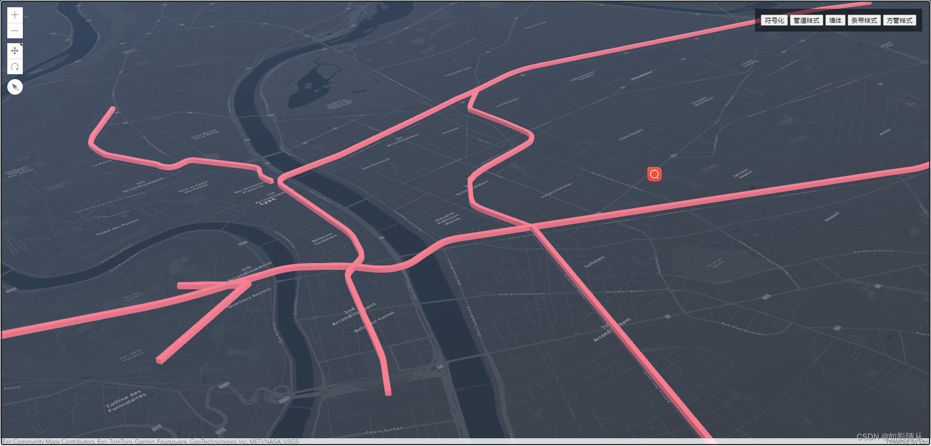
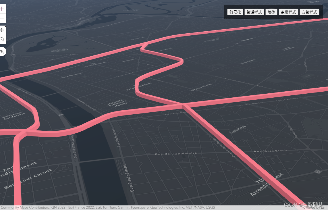
线的符号化,一般我们会给线添加一些颜色或者样式修改,也可以将其符号化为path(包括管道、墙、方管、条带等样式)
直接上代码:
<html lang="en">

<head>
  <meta charset="utf-8" />
  <meta name="viewport" content="initial-scale=1, maximum-scale=1,user-scalable=no" />
  <title>符号化-LineSymbol</title>
  <style>
    html,
    body,
    #viewDiv {
      padding: 0;
      margin: 0;
      height: 100%;
      width: 100%;
    }

    #paneDiv {
      position: absolute;
      top: 18px;
      right: 18px;
      padding: 12px;
      background-color: rgba(0, 0, 0, 0.5);
      color: white;
    }
  </style>

  <link rel="stylesheet" href="https://js.arcgis.com/4.27/esri/themes/light/main.css" />
  <script src="https://js.arcgis.com/4.27/"></script>
  <script>
    require([
      "esri/Map",
      "esri/views/SceneView",
      "esri/layers/FeatureLayer",
      "esri/layers/support/LabelClass",
      "esri/layers/GeoJSONLayer"
    ], (Map, SceneView, FeatureLayer, LabelClass, GeoJSONLayer) => {
      const map = new Map({
        basemap: "dark-gray-vector"
      });

      // Create the SceneView and set initial camera
      const view = new SceneView({
        container: "viewDiv",
        map: map,
        camera: {
          position: [109.5996, 35.6396, 9326260],
        }
      });

      let lineSymbol = {
        type: "line-3d", // autocasts as new LineSymbol3D()

        // Add two symbolizations on top of each other
        symbolLayers: [
          {
            //1.  White background line, transparent
            type: "line", // autocasts as new LineSymbol3DLayer()
            material: {
              color: [255, 255, 255, 0.3]
            },
            size: "8px"
          },
          {
            // 2. Dashed line with arrows as markers
            type: "line", // autocasts as new LineSymbol3DLayer()
            material: {
              color: [121, 72, 0]
            },
            size: "5px",
            pattern: {
              type: "style", // autocasts as new LineStylePattern3D()
              style: "long-dash"
            },
            marker: {
              type: "style", // autocasts as new LineStyleMarker3D()
              style: "arrow",
              placement: "end"
            }
          }
        ]
      }

      let stripPath = {
        type: "line-3d",  // autocasts as new LineSymbol3D()
        symbolLayers: [{
          type: "path",  // autocasts as new PathSymbol3DLayer()
          profile: "quad",  // creates a rectangular shape
          width: 20,  // path width in meters
          height: 5,  // path height in meters
          material: { color: "#ff7380" },
          cap: "square",
          profileRotation: "heading"
        }]
      };

      // create a PathSymbol3DLayer with a pipe style
      let pipePath = {
        type: "line-3d",  // autocasts as new LineSymbol3D()
        symbolLayers: [{
          type: "path",  // autocasts as new PathSymbol3DLayer()
          profile: "circle",  // creates a rectangular shape
          width: 20,  // path width will also set the height to the same value
          material: { color: "#ff7380" },
          cap: "round"
        }]
      };

      const squareTubeSymbol = {
        type: "line-3d",
        symbolLayers: [{
          type: "path",
          profile: "quad",
          material: {
            color: "#ff7380"
          },
          width: 30, // the width in m
          height: 30 // the height in m
        }]
      }

      const wallSymbol = {
        type: "line-3d",
        symbolLayers: [{
          type: "path",
          profile: "quad",
          material: {
            color:"#ff7380"
          },
          width: 5, // the width in m
          height: 30, // the height in m
          anchor: "bottom", // the vertical anchor is set to the lowest point of the wall
          profileRotation: "heading"
        }]
      }

      let pipePathRender = {
        type: "simple", // autocasts as new SimpleRenderer()
        symbol: pipePath
      }

      let stripPathRender = {
        type: "simple", // autocasts as new SimpleRenderer()
        symbol: stripPath
      }

      let squareTubeRender = {
        type: "simple", // autocasts as new SimpleRenderer()
        symbol: squareTubeSymbol
      }

      let lineSymbolRenderer = {
        type: "simple", // autocasts as new SimpleRenderer()
        symbol: lineSymbol
      }

      let wallSymbolRenderer = {
        type: "simple", // autocasts as new SimpleRenderer()
        symbol: wallSymbol
      }

      // Request feature layers and overwrite renderer
      const featureLayer = new FeatureLayer({
        url:"http://services.arcgis.com/V6ZHFr6zdgNZuVG0/arcgis/rest/services/subway_tcl_stations_lines_wgs84/FeatureServer/0",
        elevationInfo: {
          mode: "absolute-height",
          offset: 50
        }
        // renderer: lineSymbolRenderer,
      });
      map.add(featureLayer);

      view.when(function () {
        view.extent = featureLayer.fullExtent;
      })

      document.getElementById("symbolBtn").addEventListener("click", function () {
        featureLayer.renderer = lineSymbolRenderer;
        // featureLayer.renderer = stripPathRender;
      })

      document.getElementById("pathCircle").addEventListener("click", function () {
        // featureLayer.renderer = lineSymbolRenderer;
        featureLayer.renderer = pipePathRender;
      })

      document.getElementById("pathStrip").addEventListener("click", function () {
        // featureLayer.renderer = lineSymbolRenderer;
        featureLayer.renderer = stripPathRender;
      })

      document.getElementById("pathSquareTube").addEventListener("click", function () {
        // featureLayer.renderer = lineSymbolRenderer;
        featureLayer.renderer = squareTubeRender;
      })

      document.getElementById("pathWall").addEventListener("click", function () {
        // featureLayer.renderer = lineSymbolRenderer;
        featureLayer.renderer = wallSymbolRenderer;
      })


    });
  </script>
</head>

<body>
  <div id="viewDiv"></div>
  <div id="paneDiv" class="esri-widget">
    <button id="symbolBtn">符号化</button>
    <button id="pathCircle">管道样式</button>
    <button id="pathWall">墙体</button>
    <button id="pathStrip">条带样式</button>
    <button id="pathSquareTube">方管样式</button>
  </div>
</body>

</html>
基本样式
管道样式
墙体样式
条带样式
方管样式
PolygonSymbol-面符号化
面的符号化常用的也就三种:
- 水面效果
- 拉伸效果
- 填充效果
代码如下:
<html lang="en">

<head>
    <meta charset="utf-8" />
    <meta name="viewport" content="initial-scale=1, maximum-scale=1,user-scalable=no" />
    <title>符号化-Point3DSymbol</title>
    <style>
        html,
        body,
        #viewDiv {
            padding: 0;
            margin: 0;
            height: 100%;
            width: 100%;
        }

        #paneDiv {
            position: absolute;
            top: 18px;
            right: 18px;
            padding: 12px;
            background-color: rgba(0, 0, 0, 0.5);
            color: white;
        }
    </style>

    <link rel="stylesheet" href="https://js.arcgis.com/4.27/esri/themes/light/main.css" />
    <script src="https://js.arcgis.com/4.27/"></script>
    <script>
        require([
            "esri/Map",
            "esri/views/SceneView",
            "esri/layers/FeatureLayer",
            "esri/layers/support/LabelClass",
            "esri/layers/GeoJSONLayer"
        ], (Map, SceneView, FeatureLayer, LabelClass, GeoJSONLayer) => {
            const map = new Map({
                basemap: "dark-gray-vector"
            });

            // Create the SceneView and set initial camera
            const view = new SceneView({
                container: "viewDiv",
                map: map,
                camera: {
                    position: [109.5996, 35.6396, 9326260],
                    //   tilt: 40
                }
            });

            view.popupEnabled = true;

            const extrudeRenderer = {
                type: "simple", // autocasts as new SimpleRenderer()
                symbol: {
                    type: "polygon-3d", // autocasts as new PolygonSymbol3D()
                    symbolLayers: [{ type: "extrude" }] // autocasts as new ExtrudeSymbol3DLayer()
                },
                visualVariables: [
                    {
                        type: "size", // indicates this is a size visual variable
                        field: "childNum", // total population in poverty
                        normalizationField: "childNum", // total population
                        stops: [
                            {
                                value: 0.1, // features where < 10% of the pop in poverty
                                size: 10000 // will be extruded by this height in meters
                            },
                            {
                                value: 0.5, // features where > 50% of the pop in poverty
                                size: 500000 // will be extruded by this height in meters
                            }
                        ]
                    },
                    {
                        type: "color",
                        field: "childNum",
                        normalizationField: "childNum",
                        stops: [
                            {
                                value: 0.1,
                                color: "#FFFCD4",
                                opacity: 0.3
                            },
                            {
                                value: 0.35,
                                color: [153, 83, 41]
                            }
                        ]
                    }
                ]
            };

            let waterRenderer = {
                type: "simple",
                symbol: {
                    type: "polygon-3d",
                    symbolLayers: [{
                        type: "water",
                        waveDirection: 180,
                        color: "#5975a3",
                        waveStrength: "moderate",
                        waterbodySize: "large"
                    }]
                }
            }

            let fillRenderer = {
                type: "simple",
                symbol: {
                    type: "polygon-3d",  // autocasts as new PolygonSymbol3D()
                    symbolLayers: [{
                        type: "fill",  // autocasts as new FillSymbol3DLayer()
                        material: { color: "red" }
                    }]
                }
            }
            const featureLayer = new GeoJSONLayer({
                url: "./datas/china.json",
                renderer: extrudeRenderer,
                hasZ: false,
                elevationInfo: {
                    mode: "absolute-height",
                    offset: 43000
                },
                outFields: ["*"],
            });
            map.add(featureLayer);


            document.getElementById("waterBtn").addEventListener("click", () => {
                featureLayer.renderer = waterRenderer;
            });

            document.getElementById("extrudeBtn").addEventListener("click", () => {
                featureLayer.renderer = extrudeRenderer;
            });

            document.getElementById("fillBtn").addEventListener("click", () => {
                featureLayer.renderer = fillRenderer;
            });


        });
    </script>
</head>

<body>
    <div id="viewDiv"></div>
    <div id="paneDiv" class="esri-widget">
        <button id="waterBtn">水面效果</button>
        <button id="extrudeBtn">平面拉伸</button>
        <button id="fillBtn">填充效果</button>
    </div>
</body>

</html>
水面效果

拉伸效果

填充效果

MeshSymbol
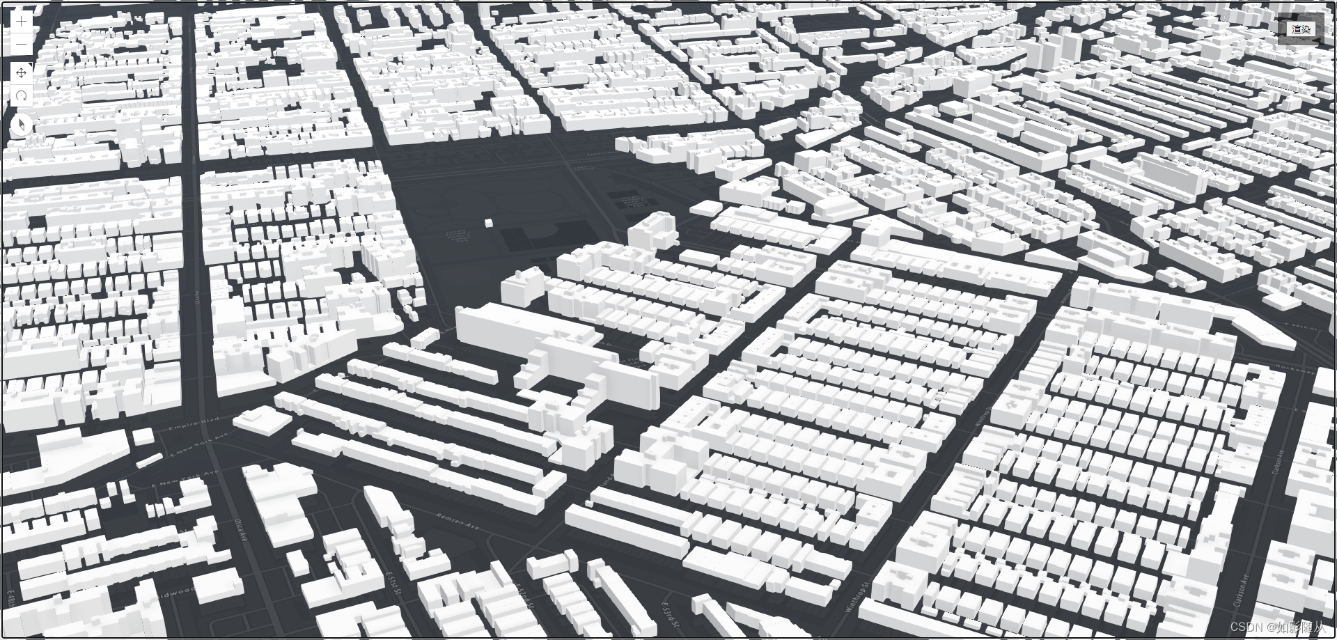
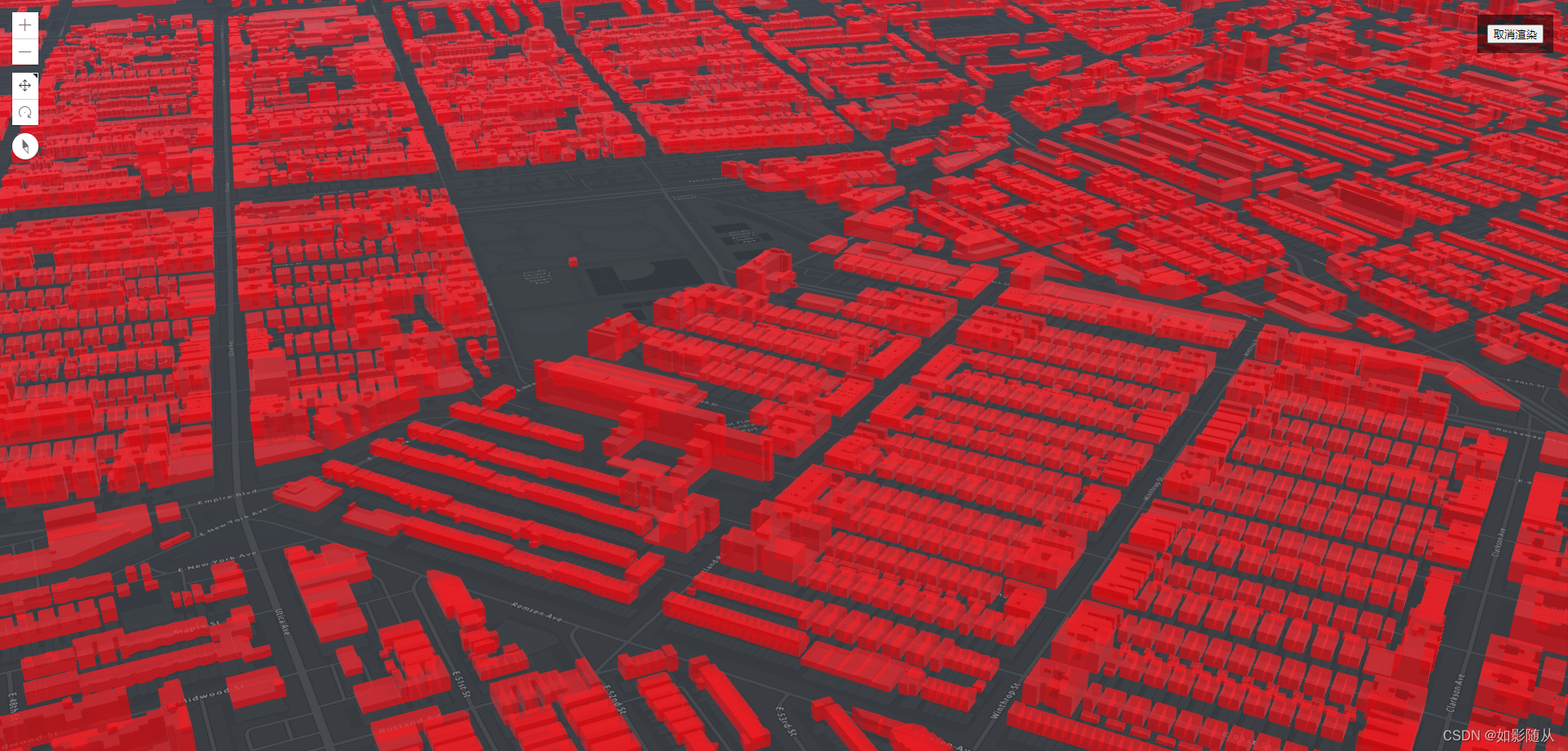
mesh符号化一般我们用于对3d object模型数据进行一些颜色样式的渲染:
<html lang="en">

<head>
    <meta charset="utf-8" />
    <meta name="viewport" content="initial-scale=1,maximum-scale=1,user-scalable=no" />
    <title>
        Intro to SceneLayer | Sample | ArcGIS Maps SDK for JavaScript 4.27
    </title>
    <style>
        html,
        body,
        #viewDiv {
            padding: 0;
            margin: 0;
            height: 100%;
            width: 100%;
        }

        #paneDiv {
            position: absolute;
            top: 18px;
            right: 18px;
            padding: 12px;
            background-color: rgba(0, 0, 0, 0.5);
            color: white;
        }

        .esri-attribution{
            display: none !important;
        }
    </style>

    <link rel="stylesheet" href="https://js.arcgis.com/4.27/esri/themes/light/main.css" />
    <script src="https://js.arcgis.com/4.27/"></script>

    <script>
        require(["esri/Map", "esri/views/SceneView", "esri/layers/SceneLayer"], (
            Map,
            SceneView,
            SceneLayer
        ) => {
            // Create Map
            const map = new Map({
                basemap: "dark-gray-vector",
                // ground: "world-elevation"
            });

            // Create the SceneView
            const view = new SceneView({
                container: "viewDiv",
                map: map
            });

            // Create SceneLayer and add to the map
            const sceneLayer = new SceneLayer({
                url:"https://tiles.arcgis.com/tiles/z2tnIkrLQ2BRzr6P/arcgis/rest/services/New_York_LoD2_3D_Buildings/SceneServer",
                popupEnabled: false
            });
            map.add(sceneLayer);

            view.when(function () {
                view.extent = sceneLayer.fullExtent;
            })

            // Create MeshSymbol3D for symbolizing SceneLayer
            const symbol = {
                type: "mesh-3d", // autocasts as new MeshSymbol3D()
                symbolLayers: [
                    {
                        type: "fill", // autocasts as new FillSymbol3DLayer()
                        // If the value of material is not assigned, the default color will be grey
                        material: {
                            color: [244, 0, 0,0.5],

                        }
                    }
                ]
            };
            // Add the renderer to sceneLayer
            let renderer = {
                type: "simple", // autocasts as new SimpleRenderer()
                symbol: symbol
            };

            let isRender = false;

            document.getElementById("renderBtn").addEventListener("click", function () {
                if (isRender) {
                    sceneLayer.renderer = null;
                    document.getElementById("renderBtn").innerHTML = "渲染"
                } else {
                    sceneLayer.renderer = renderer;
                    document.getElementById("renderBtn").innerHTML = "取消渲染"
                }
                isRender = !isRender;
            })
        });
    </script>
</head>

<body>
    <div id="viewDiv">
    </div>
    <div id="paneDiv">
        <button id="renderBtn">渲染</button>
    </div>
</body>

</html>
渲染前数据:
渲染后数据:
结语
ArcGIS提供可用于符号化的Symbol其实很多,不同的Symbol应用的场景也不一样,所以开发过程中可根据需求去选择,可以多去了解官网的示例。
![[大模型]Qwen-7B-Chat 接入langchain搭建知识库助手](https://img-blog.csdnimg.cn/direct/8e31bb780d2c4d90904223580e5b59cf.png#pic_center)

