之前做了配合地图系列批量导图的脚本工具
ArcGIS Pro脚本工具(9)——配合地图系列批量导图_学学GIS的博客-CSDN博客_arcgispro批量导出地图pngPro的地图系列是批量制图的利器,但是有个不便的地方,就是设置完成地图系列后,只能批量导出为PDF,而不能批量导出为JPG、PNG这些通用的图片格式。以上脚本即可实现将地图系列批量导出为PNG图像文件,但是使用起来还不够简单。另外有一些功能还需要加入。在示例脚本的基础上,增加实现上述功能的代码,可制作脚本工具的完整Python代码如下。不过帮助文档还是很贴心的为我们准备了解决方案。.........https://blog.csdn.net/baidu_28157641/article/details/125841844?spm=1001.2014.3001.5502经过网友提醒发现,有一种情况这个工具是满足不了的,那就是按字段属性值分类导图。
比如,有江西省所有的县, 现在需要按市级(下图中用颜色区分)各导出一张图,之前的配合地图系列批量导图工具是做不到的,因为地图系列是索引图层中的每个要素,而不是一类要素。
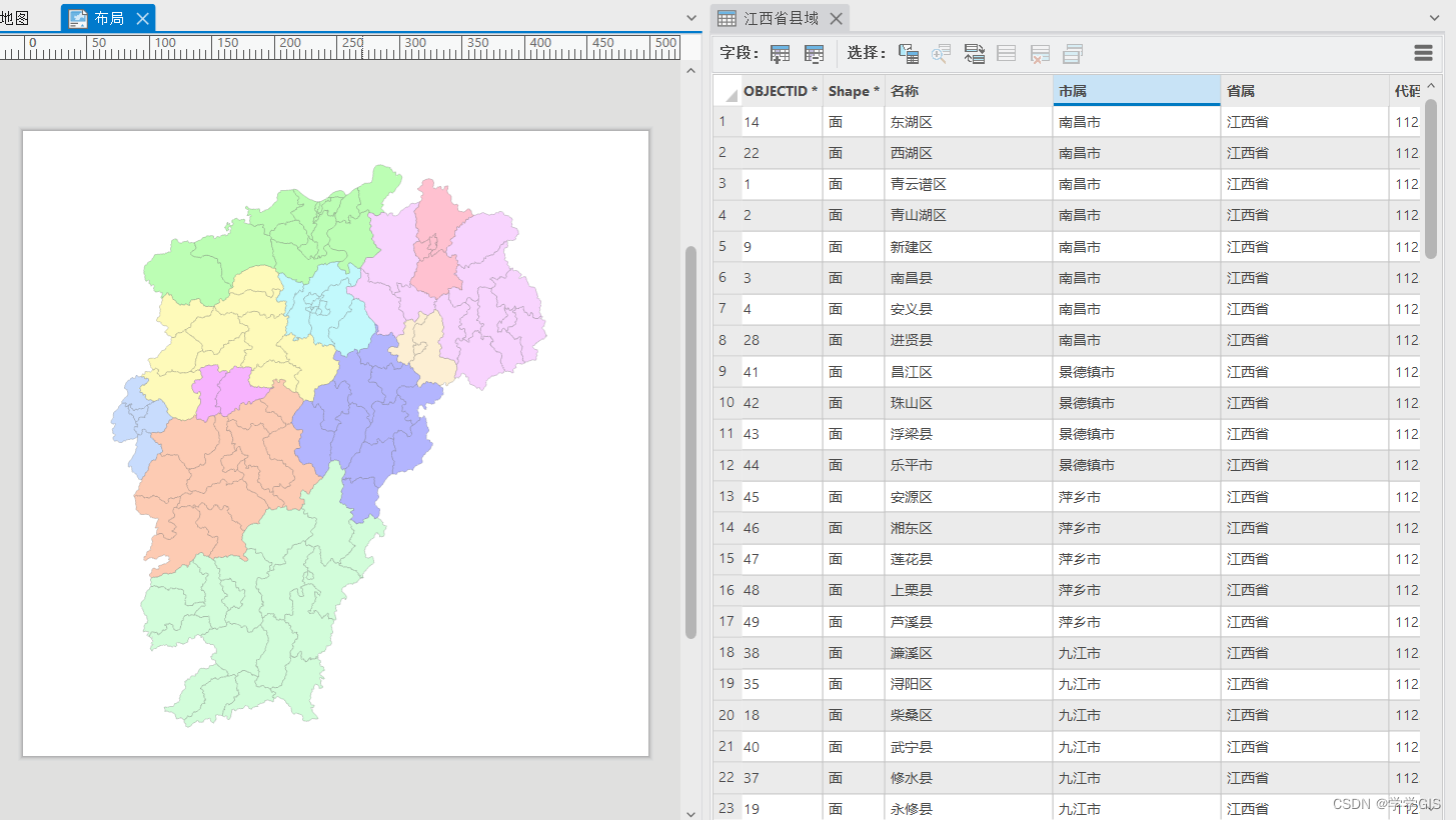
因此,需要开发一个新的工具,它可以根据索引图层的某个字段,将属性值相同的要素导出在一张图上。下面江西省所有县为例,按市级分类导图。
工具演示
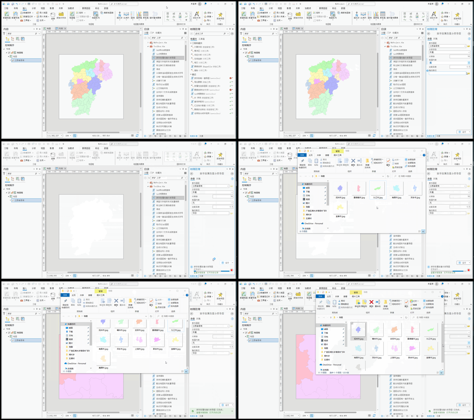
工具脚本
import arcpy
import re

aprx = arcpy.mp.ArcGISProject("CURRENT")
lyt = aprx.activeView
mf = lyt.listElements("MAPFRAME_ELEMENT")[0]
map = aprx.activeMap

lyrName = arcpy.GetParameterAsText(0)
lyr = map.listLayers(lyrName)[0]
field = arcpy.GetParameterAsText(1)

cursor = arcpy.da.SearchCursor(lyr, field)
uniqueList = []

for row in cursor:
    v = row[0]
    if v not in uniqueList:
        uniqueList.append(v)

del cursor

map.clearSelection()

dpi = arcpy.GetParameter(2)

viewRules = arcpy.GetParameterAsText(3)
margin = arcpy.GetParameter(4)
dirpath = arcpy.GetParameterAsText(5)


def clean_invalid(filename: str):
    invalid_chars = '[?,*,:,<,>,\,/,|]'
    replace_char = '_'
    return re.sub(invalid_chars, replace_char, filename)


if viewRules == "无":
    for uniqueValue in uniqueList:
        lyr.definitionQuery = field + " = '" + uniqueValue + "'"
        extent = mf.getLayerExtent(lyr)
        mf.camera.setExtent(extent)
        mf.camera.scale = mf.camera.scale/(1-margin)
        pngName = clean_invalid(uniqueValue)
        lyt.exportToJPEG(dirpath + "\\" + pngName,
                         resolution=dpi)

elif viewRules == "固定比例":
    for uniqueValue in uniqueList:
        lyr.definitionQuery = field + " = '" + uniqueValue + "'"
        extent = mf.getLayerExtent(lyr)
        mf.panToExtent(extent)
        pngName = clean_invalid(uniqueValue)
        lyt.exportToJPEG(dirpath + "\\" + pngName,
                         resolution=dpi)

else:
    for uniqueValue in uniqueList:
        lyr.definitionQuery = field + " = '" + uniqueValue + "'"
        pngName = clean_invalid(uniqueValue)
        lyt.exportToJPEG(dirpath + "\\" + pngName,
                         resolution=dpi)

lyr.updateDefinitionQueries([])
工具参数
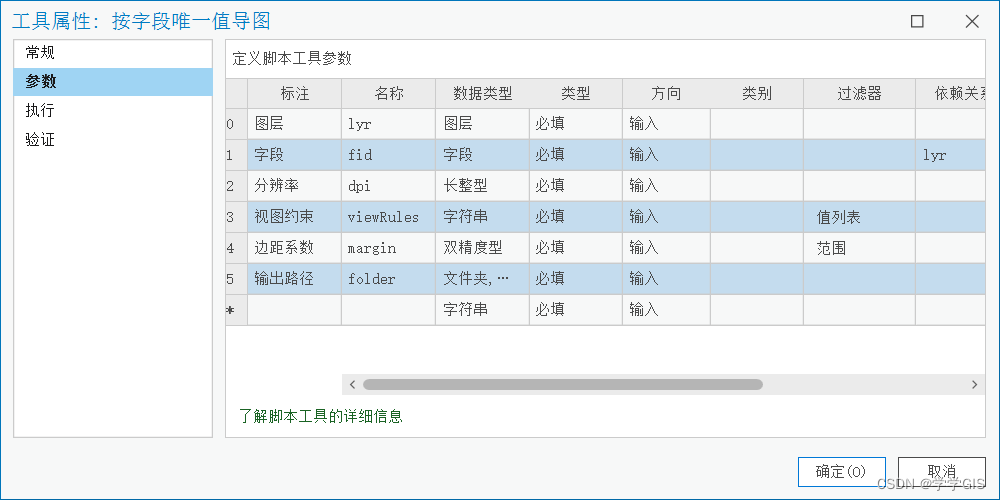
参数验证
class ToolValidator:
  # Class to add custom behavior and properties to the tool and tool parameters.

    def __init__(self):
        # set self.params for use in other function
        self.params = arcpy.GetParameterInfo()

    def initializeParameters(self):
        # Customize parameter properties.
        # This gets called when the tool is opened.
        return

    def updateParameters(self):
        # Modify parameter values and properties.
        # This gets called each time a parameter is modified, before
        # standard validation.
        if self.params[3].value=="无":
            self.params[4].enabled = True
        else:
            self.params[4].enabled = False
        return

    def updateMessages(self):
        # Customize messages for the parameters.
        # This gets called after standard validation.
        return

    # def isLicensed(self):
    #     # set tool isLicensed.
    # return True

    # def postExecute(self):
    #     # This method takes place after outputs are processed and
    #     # added to the display.
    # return
工具说明
- 需要先制作布局,布局只放置一个地图框
- 工具运行前请切换至布局视图
工具获取
代码可自取,需要完整工具请私信联系


