主要需求是实现一个电子围栏判断的小例子其中包括前端和后端的demo代码
public class GeoFenceUtils {

    /** geometryFactory */
    private static final GeometryFactory geometryFactory = new GeometryFactory();

    /**
     * 判断指定的GPS点是否在电子围栏内
     *
     * @param fencePointsList 包含电子围栏的经纬度数据的列表,格式为 "经度,纬度"
     * @param pointStr        指定的GPS点,格式为 "经度,纬度"
     * @return 如果在电子围栏内则返回true,否则返回false
     */
    public static boolean isPointInGeoFence(List<String> fencePointsList, String pointStr) {
        // 将电子围栏的经纬度数据转换为坐标数组
        Coordinate[] fencePoints = parseCoordinates(fencePointsList);

        // 将指定的GPS点转换为坐标
        Coordinate targetPoint = parseCoordinate(pointStr);

        // 创建电子围栏多边形
        Polygon geoFencePolygon = createPolygon(fencePoints);

        // 创建指定的GPS点
        Point point = geometryFactory.createPoint(targetPoint);

        // 检查指定的GPS点是否在电子围栏内
        return geoFencePolygon.contains(point);
    }

    /**
     * 判断指定的GPS点是否在电子围栏内
     *
     * @param geoFencePolygon geo fence polygon
     * @param pointStr        指定的GPS点,格式为 "经度,纬度"
     * @return 如果在电子围栏内则返回true ,否则返回false
     * @since 2.0.0
     */
    public static boolean isPointInGeoFence(Polygon geoFencePolygon, String pointStr) {
        // 将指定的GPS点转换为坐标
        Coordinate testPoint = parseCoordinate(pointStr);

        // 创建指定的GPS点
        Point point = geometryFactory.createPoint(testPoint);

        // 检查指定的GPS点是否在电子围栏内
        return geoFencePolygon.contains(point);
    }

    /**
     * 判断指定的GPS点是否在电子围栏内
     *
     * @param fencePointsList 包含电子围栏的经纬度数据的列表,格式为 "经度,纬度"
     * @return 如果在电子围栏内则返回true,否则返回false
     */
    public static Polygon getPointInGeoFence(List<String> fencePointsList) {
        // 将电子围栏的经纬度数据转换为坐标数组
        Coordinate[] fencePoints = parseCoordinates(fencePointsList);
        // 创建电子围栏
        return createPolygon(fencePoints);
    }


    /**
     * 根据GPS点集合创建多边形
     *
     * @param coordinates GPS点集合
     * @return 多边形对象
     */
    private static Polygon createPolygon(Coordinate[] coordinates) {
        // Ensure the polygon is closed by adding the first coordinate at the end if necessary
        if (!coordinates[0].equals(coordinates[coordinates.length - 1])) {
            Coordinate[] closedCoordinates = new Coordinate[coordinates.length + 1];
            System.arraycopy(coordinates, 0, closedCoordinates, 0, coordinates.length);
            closedCoordinates[closedCoordinates.length - 1] = coordinates[0];
            coordinates = closedCoordinates;
        }
        return geometryFactory.createPolygon(coordinates);
    }

    /**
     * 将包含经纬度数据的列表转换为坐标数组
     *
     * @param pointsList 包含经纬度数据的列表
     * @return 坐标数组
     */
    private static Coordinate[] parseCoordinates(List<String> pointsList) {
        Coordinate[] coordinates = new Coordinate[pointsList.size()];
        for (int i = 0; i < pointsList.size(); i++) {
            coordinates[i] = parseCoordinate(pointsList.get(i));
        }
        return coordinates;
    }

    /**
     * 将经纬度数据字符串转换为坐标
     *
     * @param pointStr 经纬度数据字符串,格式为 "经度,纬度"
     * @return 坐标
     */
    private static Coordinate parseCoordinate(String pointStr) {
        String[] parts = pointStr.split(StringPool.COMMA);
        double lon = Double.parseDouble(parts[0]);
        double lat = Double.parseDouble(parts[1]);
        return new Coordinate(lon, lat);
    }

}
单元测试类
public class GeoFenceUtilTest {


    /**
     * Test geo
     *
     * @since 2.0.0
     */
    @Test
    public void testGeo() {
        // 示例电子围栏点集合
        List<String> fencePointsList = List.of(
                "116.403322,39.920255",
                "116.429043,39.913906",
                "116.438447,39.882655",
                "116.419252,39.873514",
                "116.406656,39.881143",
                "116.389347,39.884167",
                "116.389846,39.891365",
                "116.377436,39.908228",
                "116.410512,39.901984"
        );

        // 指定的GPS点
        String testPointStr = "116.384112,39.899172";
        // 检查指定的GPS点是否在电子围栏内
        boolean isWithinFence = GeoFenceUtils.isPointInGeoFence(fencePointsList, testPointStr);
        System.out.println("指定的GPS点是否在电子围栏内: " + isWithinFence);
    }

}
前端的测试demo,高德开放平台JS API测试平台,找到多边形编辑器,将下面的代码粘贴到执行器里面,然后点击右上角的执行代码,就可以获取到对应范围的点位地址
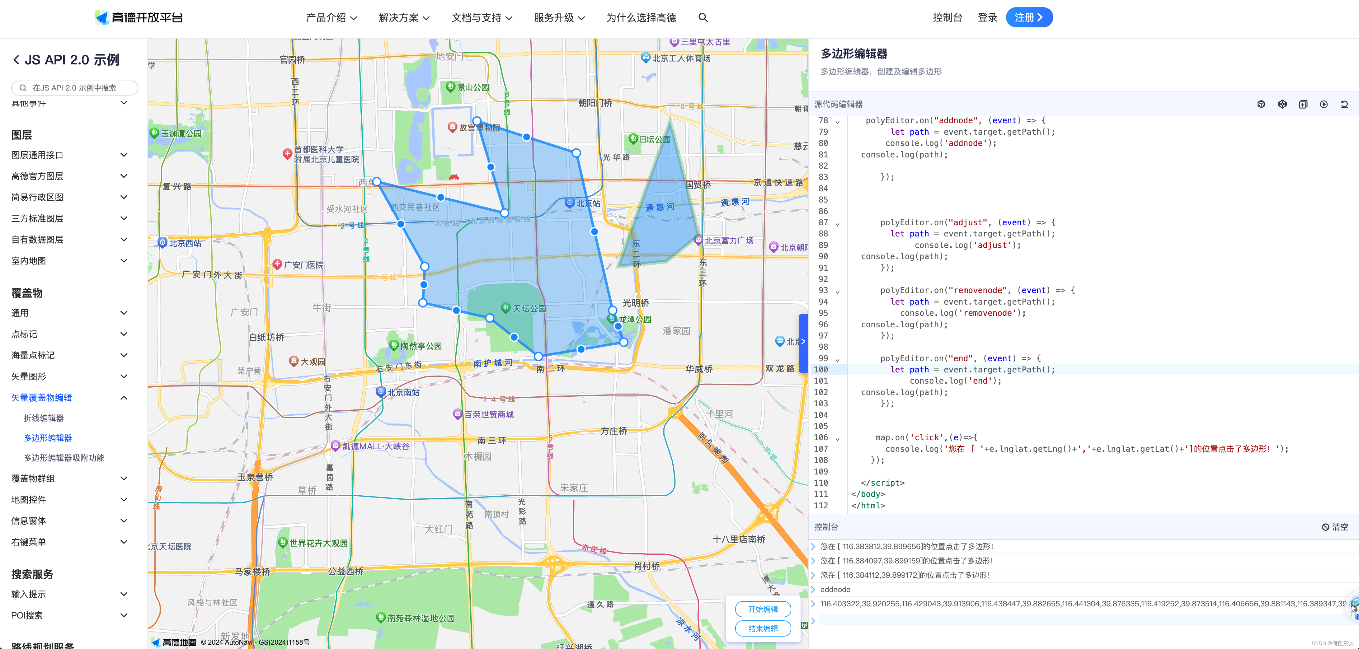
<!doctype html>
<html>
<head>
    <meta charset="utf-8">
    <meta http-equiv="X-UA-Compatible" content="IE=edge">
    <meta name="viewport" content="initial-scale=1.0, user-scalable=no, width=device-width">
    <style>
    html,
    body,
    #container {
      width: 100%;
      height: 100%;
    }
    </style>
    <title>多边形的绘制和编辑</title>
    <link rel="stylesheet" href="https://a.amap.com/jsapi_demos/static/demo-center/css/demo-center.css" />
    <script src="https://webapi.amap.com/maps?v=2.0&key=您申请的key值&plugin=AMap.PolygonEditor"></script>
    <script src="https://a.amap.com/jsapi_demos/static/demo-center/js/demoutils.js"></script>
</head>
<body>
<div id="container"></div>
<div class="input-card" style="width: 120px">
   <button class="btn" onclick="polyEditor.open()" style="margin-bottom: 5px">开始编辑</button>
   <button class="btn" onclick="polyEditor.close()">结束编辑</button>
</div>
<script type="text/javascript">
    var map = new AMap.Map("container", {
      center: [116.400274, 39.905812],
      zoom: 14,
      viewMode: '3D',
    });

    var path = [
      [116.403322, 39.920255],
      [116.410703, 39.897555],
      [116.402292, 39.892353],
      [116.389846, 39.891365]
    ]
    var path1 = [
      [116.453322, 39.920255],
      [116.460703, 39.897555],
      [116.452292, 39.892353],
      [116.439846, 39.891365]
    ]

    var polygon = new AMap.Polygon({
      path: path,
      strokeColor: "#FF33FF",
      strokeWeight: 6,
      strokeOpacity: 0.2,
      fillOpacity: 0.4,
      fillColor: '#1791fc',
      zIndex: 50,
      bubble: true,
    })
    var polygon1 = new AMap.Polygon({
      path: path1,
      strokeColor: "green",
      strokeWeight: 6,
      strokeOpacity: 0.2,
      fillOpacity: 0.4,
      fillColor: '#1791fc',
      zIndex: 50,
      bubble: true,

    })
    map.add([polygon, polygon1])

    // 缩放地图到合适的视野级别
    map.setFitView()
    var polyEditor;
      // var polyEditor = new AMap.PolyEditor(map, polygon)
      // polyEditor = new AMap.PolygonEditor(map)
    polyEditor = new AMap.PolygonEditor(map, polygon);
    polyEditor.addAdsorbPolygons(polygon1)
    polyEditor.open();

   polyEditor.on("addnode", (event) => {
        let path = event.target.getPath();
       console.log('addnode');
  console.log(path);

      });


      polyEditor.on("adjust", (event) => {
        let path = event.target.getPath();
             console.log('adjust');
  console.log(path);
      });

      polyEditor.on("removenode", (event) => {
        let path = event.target.getPath();
          console.log('removenode');
  console.log(path);
      });

      polyEditor.on("end", (event) => {
        let path = event.target.getPath();
            console.log('end');
  console.log(path);
      });


     map.on('click',(e)=>{
       console.log('您在 [ '+e.lnglat.getLng()+','+e.lnglat.getLat()+']的位置点击了多边形!');
    });

  </script>
</body>
</html>


![[C++][设计模式][访问器]详细讲解](https://img-blog.csdnimg.cn/direct/c61a50f4955e4d518965e670e83269b4.png)