Cesium 地球网格构造
Cesium原理篇:3最长的一帧之地形(2:高度图)
HeightmapTessellator
用于从高程图像创建网格。提供了一个函数 computeVertices,可以根据高程图像创建顶点数组。
该函数的参数包括高程图像、高度数据的结构、网格宽高、边缘裙板高度、矩形范围、相机中心点等。函数的实现使用了许多性能优化技巧,如将函数内常量化、内联等。
该模块的输出为一个对象,包括创建好的顶点数组、最大与最小高度、该网格的边界球、边界方向盒等信息。
1、函数定义
// 声明
static computeVertices(options) {}
// 使用
const width = 5;
const height = 5;
const statistics = Cesium.HeightmapTessellator.computeVertices({
    heightmap : [1.0, 2.0, 3.0, 4.0, 5.0, 6.0, 7.0, 8.0, 9.0],
    width : width,
    height : height,
    skirtHeight : 0.0,
    nativeRectangle : {
        west : 10.0,
        east : 20.0,
        south : 30.0,
        north : 40.0
    }
});

const encoding = statistics.encoding;
const position = encoding.decodePosition(statistics.vertices, index);
options 参数:
| 参数 | 类型 | 描述 |
|---|---|---|
| heightmap | Array | 要镶嵌的高度图。 |
| width | number | 高度图的宽度(以高度样本计)。 |
| height | number | 高度图的高度(以高度样本计)。 |
| skirtHeight | number | 要悬垂在高度图边缘的裙子的高度。 |
| nativeRectangle | Rectangle | 高度贴图投影的原始坐标中的矩形。对于具有地理投影的高度图,这是度数。对于 Web 墨卡托投影,这是米。 |
| exaggeration | number | 用于夸大地形的比例尺。默认为1. |
| exaggerationRelativeHeight | number | 地形夸大的高度,以米为单位。默认为0. |
| rectangle | Rectangle | 高度图覆盖的矩形,大地坐标为北、南、东和西属性(弧度)。必须提供矩形或本机矩形。如果同时提供两者,则假定它们是一致的。 |
| isGeographic | boolean | 如果高度图使用{@link GeographicProjection},则为true;如果使用{@link WebMercatorProjection},则为false。默认为true。 |
| relativeToCenter | Cartesian3 | 将计算出的位置作为Cartesian3.subtract(worldPosition, relativeToCenter)。默认为Cartesian3.ZERO。 |
| ellipsoid | Ellipsoid | 高度贴图适用的椭球体。默认为Ellipsoid.WGS84。 |
| structure | object | 描述高度数据结构的对象。 |
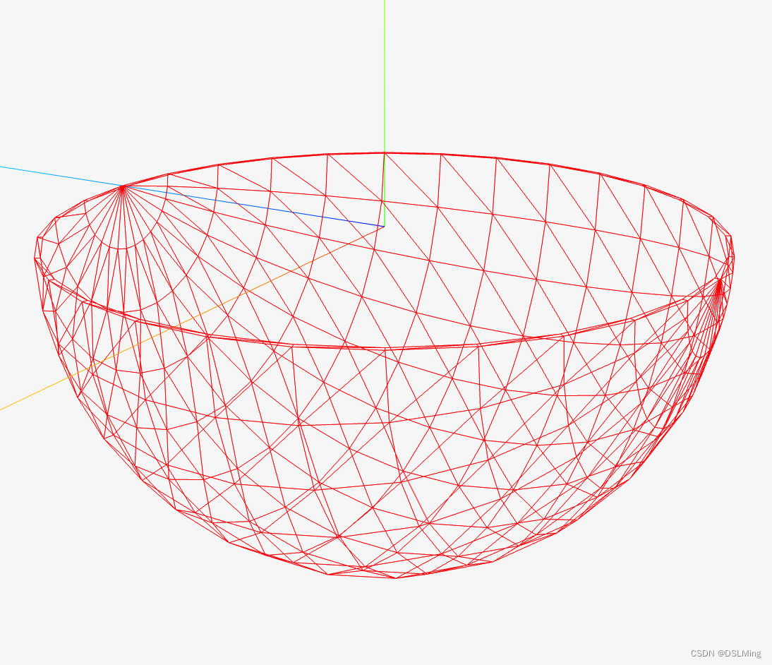
裙边(skirt)
防止不同层级mesh加载时出现裂缝
实现
  static computeVertices(options) {
    const cos = Math.cos;
    const sin = Math.sin;
    const sqrt = Math.sqrt;
    const toRadians = CesiumMath.toRadians;

    const heightmap = options.heightmap;
    const width = options.width;
    const height = options.height;
    const skirtHeight = options.skirtHeight;
    const hasSkirts = skirtHeight > 0.0;

    const ellipsoid = defaultValue(options.ellipsoid, Ellipsoid.WGS84);

    const nativeRectangle = Rectangle.clone(options.nativeRectangle);
    const rectangle = Rectangle.clone(options.rectangle);

    const geographicWest = rectangle.west;
    const geographicSouth = rectangle.south;
    const geographicEast = rectangle.east;
    const geographicNorth = rectangle.north;

    const relativeToCenter = options.relativeToCenter;
    const includeWebMercatorT = defaultValue(options.includeWebMercatorT, false);

    const exaggeration = defaultValue(options.exaggeration, 1.0);
    const exaggerationRelativeHeight = defaultValue(
      options.exaggerationRelativeHeight,
      0.0
    );
    const hasExaggeration = exaggeration !== 1.0;
    const includeGeodeticSurfaceNormals = hasExaggeration;

    const rectangleWidth = Rectangle.computeWidth(nativeRectangle);
    const rectangleHeight = Rectangle.computeHeight(nativeRectangle);

    // 每个网格的长宽
    const granularityX = rectangleWidth / (width - 1);
    const granularityY = rectangleHeight / (height - 1);

    const radiiSquared = ellipsoid.radiiSquared;
    const radiiSquaredX = radiiSquared.x;
    const radiiSquaredY = radiiSquared.y;
    const radiiSquaredZ = radiiSquared.z;

    let minimumHeight = 65536.0;
    let maximumHeight = -65536.0;

    const fromENU = Transforms.eastNorthUpToFixedFrame(
      relativeToCenter,
      ellipsoid
    );

    const minimum = minimumScratch;
    minimum.x = Number.POSITIVE_INFINITY;
    minimum.y = Number.POSITIVE_INFINITY;
    minimum.z = Number.POSITIVE_INFINITY;

    const maximum = maximumScratch;
    maximum.x = Number.NEGATIVE_INFINITY;
    maximum.y = Number.NEGATIVE_INFINITY;
    maximum.z = Number.NEGATIVE_INFINITY;

    let hMin = Number.POSITIVE_INFINITY;

    const gridVertexCount = width * height;
    const edgeVertexCount = skirtHeight > 0.0 ? width * 2 + height * 2 : 0;
    const vertexCount = gridVertexCount + edgeVertexCount;

    const positions = new Array(vertexCount);
    const heights = new Array(vertexCount);
    const uvs = new Array(vertexCount);

    let startRow = 0;
    let endRow = height;
    let startCol = 0;
    let endCol = width;

    if (hasSkirts) {
      --startRow;
      ++endRow;
      --startCol;
      ++endCol;
    }

    for (let rowIndex = startRow; rowIndex < endRow; ++rowIndex) {
      let row = rowIndex;
      if (row < 0) {
        row = 0;
      }
      if (row >= height) {
        row = height - 1;
      }

      //
      //  ^ latitude(纬度)
      //  |
      //  |              North(90)
      //  |              ---------
      //  |             |         |
      //  |  West(-180) |         | East(0)
      //  |             |         |
      //  |              ---------
      //  |              South(-90)
      //  -----------------------------> longitude(经度)
      // 地理坐标系下

      // 当前纬度(latitude) 距离最北头(North) 的距离
      // 这个值是越来越小的, 随着行数越来越大
      let latitude = nativeRectangle.north - granularityY * row;
      latitude = toRadians(latitude);

      // 当前纬度(latitude) 距离最南头(South) 的百分比(0~1)
      let v = (latitude - geographicSouth) / (geographicNorth - geographicSouth);
      v = CesiumMath.clamp(v, 0.0, 1.0);

      const isNorthEdge = rowIndex === startRow;
      const isSouthEdge = rowIndex === endRow - 1;

      const cosLatitude = cos(latitude);
      const nZ = sin(latitude);
      const kZ = radiiSquaredZ * nZ;

      for (let colIndex = startCol; colIndex < endCol; ++colIndex) {
        let col = colIndex;
        if (col < 0) {
          col = 0;
        }
        if (col >= width) {
          col = width - 1;
        }

        const terrainOffset = row * width + col;

        let heightSample = heightmap[terrainOffset]

        let longitude = nativeRectangle.west + granularityX * col;
        longitude = toRadians(longitude);

        let u = (longitude - geographicWest) / (geographicEast - geographicWest);
        u = CesiumMath.clamp(u, 0.0, 1.0);

        let index = row * width + col;

        if (skirtHeight > 0.0) {
          const isWestEdge = colIndex === startCol;
          const isEastEdge = colIndex === endCol - 1;
          const isEdge = isNorthEdge || isSouthEdge || isWestEdge || isEastEdge;
          const isCorner = (isNorthEdge || isSouthEdge) && (isWestEdge || isEastEdge);

          if (isCorner) {
            // Don't generate skirts on the corners.
            continue;
          } else if (isEdge) {
            heightSample -= skirtHeight;

            if (isWestEdge) {
              // The outer loop iterates north to south but the indices are ordered south to north, hence the index flip below
              // 外循环从北到南迭代,但索引按从南到北的顺序排列,因此索引在下面翻转
              index = gridVertexCount + (height - row - 1);
            } else if (isSouthEdge) {
              // Add after west indices. South indices are ordered east to west.
              // 加在西方指数之后。南方指数是从东向西排列的。
              index = gridVertexCount + height + (width - col - 1);
            } else if (isEastEdge) {
              // Add after west and south indices. East indices are ordered north to south. The index is flipped like above.
              // 在西部和南部指数后加上。东部指数是从北向南排列的。索引如上所述翻转。
              index = gridVertexCount + height + width + row;
            } else if (isNorthEdge) {
              // Add after west, south, and east indices. North indices are ordered west to east.
              // 在西部、南部和东部指数后添加。北方指数是从西向东排列的。
              index = gridVertexCount + height + width + height + col;
            }
          }
        }

        // 经纬度转笛卡尔坐标系
        const nX = cosLatitude * cos(longitude);
        const nY = cosLatitude * sin(longitude);

        const kX = radiiSquaredX * nX;
        const kY = radiiSquaredY * nY;

        const gamma = sqrt(kX * nX + kY * nY + kZ * nZ);
        const oneOverGamma = 1.0 / gamma;

        const rSurfaceX = kX * oneOverGamma;
        const rSurfaceY = kY * oneOverGamma;
        const rSurfaceZ = kZ * oneOverGamma;

        const position = new Cartesian3();
        position.x = rSurfaceX + nX * heightSample;
        position.y = rSurfaceY + nY * heightSample;
        position.z = rSurfaceZ + nZ * heightSample;

        hMin = Math.min(hMin, heightSample);

        positions[index] = position;
        uvs[index] = new Cartesian2(u, v);
        heights[index] = heightSample;
      }
    }

    const aaBox = new AxisAlignedBoundingBox(minimum, maximum, relativeToCenter);
    const encoding = new TerrainEncoding(
      relativeToCenter,
      aaBox,
      hMin,
      maximumHeight,
      fromENU,
      false,
      includeWebMercatorT,
      includeGeodeticSurfaceNormals,
      exaggeration,
      exaggerationRelativeHeight
    );
    const vertices = new Float32Array(vertexCount * encoding.stride);

    let bufferIndex = 0;
    for (let j = 0; j < vertexCount; ++j) {
      bufferIndex = encoding.encode(
        vertices,
        bufferIndex,
        positions[j],
        uvs[j],
        heights[j],
        undefined,
        undefined,
        undefined
      );
    }

    return {
      vertices: vertices,
    };
  }