导读
在日常生活中,我们经常能看见查询附近商家的功能。
常见的场景有,比如你在点外卖的时候,就可能需要按照距离查询附近几百米或者几公里的商家。
本文将介绍如何使用Redis实现按照距离查询附近商户的功能,并以SpringBoot项目作为举例。
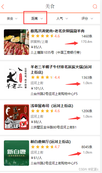
想知道这样的功能是如何实现的吗?接着往下看吧!
Redis地理位置功能
Redis是一种高性能的键值存储数据库,具有快速读写能力和丰富的数据结构支持。在Redis 3.2版本之后,它引入了地理位置(Geospatial)功能,使其可以轻松处理与地理位置相关的数据。
地理位置功能的核心数据结构是有序集合(Sorted Set),它将元素与分数(score)关联起来。在地理位置功能中,分数表示地理位置的经度和纬度,而元素则是一个标识符,比如商户的ID。
我们只需要在数据库中存储商家的经纬度,以商家id作为key,经纬度作为value存入redis中,就可以通过redis命令来获得以某一个点为圆心一定范围内的商家,以及他们之间的距离。
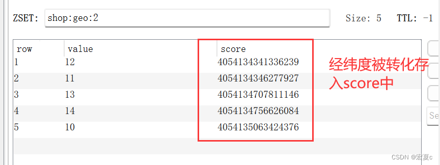
常用命令
1. GEOADD:将地理位置添加到有序集合中
使用GEOADD命令,可以将一个或多个地理位置添加到有序集合中。语法如下:
GEOADD key longitude latitude member [longitude latitude member ...]

示例:
   GEOADD stores 116.404 39.915 "storeA"
   GEOADD stores 116.418 39.917 "storeB"
2. GEODIST:计算两个位置之间的距离
GEODIST命令用于计算两个位置之间的距离,可以指定单位(米、千米、英里、英尺等)。
   GEODIST key member1 member2 [unit]

   示例:

   GEODIST stores storeA storeB km
3. GEORADIUS:按照距离查询位置范围内的元素
GEORADIUS命令用于在指定的地理位置范围内查询元素。它可以按照经纬度坐标和半径来查询,还可以限制返回的结果数量。
 GEORADIUS key longitude latitude radius unit [WITHCOORD] [WITHDIST] [WITHHASH] [COUNT count] [ASC|DESC] [STORE key]

   示例:

   GEORADIUS stores 116.408 39.916 1 km WITHDIST COUNT 5
4. GEOHASH:获取位置的geohash值
GEOHASH命令用于获取指定位置的geohash值,geohash是一种将地理位置编码成字符串的方法,可以用于快速近似的位置计算。
 GEOHASH key member [member ...]

   示例:

   GEOHASH stores storeA storeB
5. GEOPOS:获取一个或多个位置的经纬度坐标
GEOPOS命令用于获取一个或多个位置的经纬度坐标。
   GEOPOS key member [member ...]

   示例:

   GEOPOS stores storeA storeB
6. GEORADIUSBYMEMBER:根据成员获取范围内的元素
这个命令与GEORADIUS类似,但是它以一个已有的成员作为中心点进行查询。
   GEORADIUSBYMEMBER key member radius unit [WITHCOORD] [WITHDIST] [WITHHASH] [COUNT count] [ASC|DESC] [STORE key]

   示例:

   GEORADIUSBYMEMBER stores storeA 1 km
地理位置功能不仅在查询附近商户等实际应用中非常有用,还可以应用于地理分析、位置推荐等领域。它通过利用Redis强大的有序集合数据结构,使得处理地理信息变得高效、灵活,并且易于集成到现有的应用中。无论是构建LBS应用还是处理位置相关数据,Redis的地理位置功能都能为开发者提供强大的支持。
Java代码实现
将数据库中的商家经纬度存入redis
数据库中有一张商家表,其中有经度,纬度这两个字段。我们可以通过单元测试批量将这些商家的经纬度数据存入redis。key为商家id,value为经纬度。
/**
     * 将数据库中的商户坐标添加到缓存
     */
    @Test
    void addShopGeo2Redis(){
        //获取商户集合
        List<Shop> list = shopService.list();
        //根据商户类型分类
        Map<Long, List<Shop>> collect = list.stream().collect(Collectors.groupingBy(Shop::getTypeId));
        for (Map.Entry<Long, List<Shop>> longListEntry : collect.entrySet()) {
            Long typeId = longListEntry.getKey();
            String key = "shop:geo:" + typeId;
            //获取商户经纬度
            List<Shop> shopList = longListEntry.getValue();
            List<RedisGeoCommands.GeoLocation<String>> locations = new ArrayList<>(shopList.size());
            for (Shop shop : shopList) {
//                stringRedisTemplate.opsForGeo().add(key,new Point(shop.getX(),shop.getY()),shop.getId().toString());
                //先收集完所有商户的地理位置,再一次性添加到redis
                locations.add(new RedisGeoCommands.GeoLocation<>(shop.getId().toString(),new Point(shop.getX(),shop.getY())));
            }
            stringRedisTemplate.opsForGeo().add(key,locations);
        }
    }
接口类:queryShopByType(typeId,current,x,y)
定义一个根据商家类型查询所有商家的接口,如果前端传来的参数中携带该用户的经纬度,则代表需要根据距离查询附近商家。
  /**
     * 根据商铺类型分页查询商铺信息
     * @param typeId 商铺类型
     * @param current 页码
     * @return 商铺列表
     */
    @GetMapping("/of/type")
    public Result queryShopByType(
            @RequestParam("typeId") Integer typeId,
            @RequestParam(value = "current", defaultValue = "1") Integer current,
            @RequestParam(value = "x", required = false) Double x,
            @RequestParam(value = "y", required = false) Double y
    ) {

        return shopService.queryShopByType(typeId, current, x, y);
    }
服务类:queryShopByType(typeId,current,x,y)
1.首先判断是否经纬度参数x和y是否为空
2.计算分页参数(redis无法分页,需要手动分页)
3.查询redis
4.获取商户id集合
5.根据商户id查询数据库
6.返回
  @Override
    public Result queryShopByType(Integer typeId, Integer current, Double x, Double y) {
        //1.判断是否需要根据坐标查询
        if(x == null || y == null){
            //直接数据库查询
            Page<Shop> page = query().eq("type_id", typeId).page(new Page<>(current, SystemConstants.DEFAULT_PAGE_SIZE));
            return Result.ok(page.getRecords());
        }
        //2.计算分页参数
        int from = (current - 1) * SystemConstants.DEFAULT_PAGE_SIZE;
        int end = current * SystemConstants.DEFAULT_PAGE_SIZE;

        //3.查询redis,按照距离排序,分页。结果:shopId,distance
        String key = SHOP_GEO_KEY + typeId;
        GeoResults<RedisGeoCommands.GeoLocation<String>> results = stringRedisTemplate.opsForGeo()
                .search(
                        key,
                        GeoReference.fromCoordinate(x, y),
                        new Distance(5000),
                        RedisGeoCommands.GeoSearchCommandArgs.newGeoSearchArgs().includeDistance().limit(end)
                );

        //4.解析出id
        if(results == null){
            return Result.ok(Collections.emptyList());
        }
        List<GeoResult<RedisGeoCommands.GeoLocation<String>>> list = results.getContent();
        if(list.size() <= from){
            //没有下一页
            return Result.ok(Collections.emptyList());
        }
        //4.1截取from——end部分
        List<Long> ids = new ArrayList<>(list.size());
        Map<String, Distance> distanceMap = new HashMap<>(list.size());
        list.stream().skip(from).forEach(result -> {
            String shopIdStr = result.getContent().getName();
            ids.add(Long.valueOf(shopIdStr));
            Distance distance = result.getDistance();
            distanceMap.put(shopIdStr,distance);
        });
        //5.根据id查询shop
        String idStr = StrUtil.join(",",ids);
        List<Shop> shops = query().in("id",ids).last("ORDER BY FIELD(id," + idStr + ")").list();
        for (Shop shop : shops){
            shop.setDistance(distanceMap.get(shop.getId().toString()).getValue());
        }

        //6.返回
        return Result.ok(shops);
    }
}
注意点
1.redis查询的结果是从第1条到第end条,不能直接返回第begin条到第end条。
那么如何跳过begin前面的记录呢?
可以使用stream()流的skip()方法,skip()方法中指定参数begin,就会跳过前面的begin条记录。
2.通过redis获取的ids集合,再使用mybatis-plus使用query().in()进行查询时,会破坏数据顺序,如何解决?
手动指定顺序。在后面加上last("ORDER BY FIELD(id," + idStr + ")").list()。而idStr = StrUtil.join(",",ids);


